Category
page 1Allgäu Alps
Allgäu Alps
mountain range of the Northern Limestone Alps, subsection of the Bavarian Alps
Mädelegabel
The Mädelegabel is a 2,645 metre high mountain, made of main dolomite, in the Allgäu Alps near Oberstdorf. It is one of the best-known and most-climbed high peaks in the German Alps, Within the Allgäu Alps it is the fourth-highest summit, with rock faces up to 400 metres high. Together with the Trettachspitze and the Hochfrottspitze it forms the famous triumvirate of peaks on the main crest of the Allgäu. Its name comes from Mähder - a mown mountain pasture in the vicinity - and gabel from the appearance of the triumvirate to the north which recalls a fork (German: Gabel). Originally the
Krottenkopf
highest mountain of the Allgäu Alps in Tyrol, Austria
Nebelhorn
The Nebelhorn is a mountain in the Allgäu Alps in Germany, near the village of Oberstdorf. It lends its name to the Nebelhorn Trophy figure skating competition and the Nebelhorn Classics, a freeride race event. Also, the Nine Knights freeski contest takes place just above the "Höfatsblick" station of the Nebelhornbahn.

Hochfrottspitze
The Hochfrottspitze is a mountain, made of main dolomite, in the Allgäu Alps near Oberstdorf in Germany and the highest German mountain in the Allgäu Alps. The border with Austria runs along its ridge.
Sorgschrofen
Sorgschrofen is a mountain in the Allgäu Alps of Bavaria, Germany and Tyrol, Austria. A lower summit of Sorgschrofen is the Zinken. There is a summit cross on both Sorgschrofen and Zinken.
Biberkopf
The Biberkopf is a 2,599 m high mountain in the Alps on the border between Germany and Austria.
Hohes Licht
mountain of the Allgäu Alps in Tyrol, Austria

Bockkarkopf
The Bockkarkopf is a mountain, 2,609 m high, and part of the main ridge of the Allgäu Alps. It is the ninth highest peak in the Allgäu Alps and is located between the Wilder Mann to the southwest and the Hochfrottspitze to the northeast. The busy Heilbronn Way (Heilbronner Weg) runs over the pyramidal peak.
Trettachspitze
The Trettachspitze is a mountain in the Allgäu Alps in Germany. Due to its striking appearance (a very steep, narrow horn of rock when seen from the west and east) it is one of the best-known mountains in the Allgäu Alps.
Rote Flüh
mountain of the Allgäu Alps in Tyrol, Austria
Fellhorn
The Fellhorn () is a mountain in the "Allgäu Alps" near Oberstdorf, Germany, on the border with Austria. It is known for its fields of alpenroses (Rhododendron ferrugineum). According to Austrian sources the mountain is .
Widderstein
mountain of the Allgäu Alps in Vorarlberg, Austria

Marchspitze
The Marchspitze () is a prominent summit, made of main dolomite, in the Hornbach chain of the Allgäu Alps. It is located 1.5 kilometres east of the much better known Großer Krottenkopf and is entirely on Austrian soil.

Urbeleskarspitze
thumb|The northwest flank of the Urbeleskarspitze seen from Urbeleskar
The Urbeleskarspitze is a 2,632-metre-high mountain peak in the Allgäu Alps. It lies within Austria in the state of Tyrol and is the fifth-highest summit in the Allgäu Alps and the second-highest peak in the Hornbach chain. Its neighbours in the Hornbach chain are the Bretterspitze to the southwest and the Zwölfer Spitze to the northeast.

Bretterspitze
The Bretterspitze is a 2,608-metre-high summit in the Austrian state of Tyrol. It is part of the Hornbach chain in the Allgäu Alps. Its neighbouring peaks in the Hornbach chain are the Gliegerkarspitze to the west and the Urbeleskarspitze to the northeast. The broad summit block of the Bretterspitze is made of main dolomite.
Lahnerkopf
Lahnerkopf is a mountain located on the border of Bavaria, Germany and Tyrol, Austria. It is high.
Grünten
Grünten (also, Watcher of the Allgäu) is a mountain of Bavaria, Germany.
On the summit is a Gebirgsjäger monument, dedicated to German mountain troopers killed in World War One. Not far from there, on the lower crest, is a radio tower of the Bavarian Broadcasting Corporation. The cable car connecting the village of Rettenberg and the radio tower was closed to the public in 2014 and is now only used to transport material or members of staff up to the radio tower.

Tannheim Mountains
alpine supergroup of the Allgäu Alps in Tyrol, Austria, and Bavaria, Germany
Noppenspitze
The Noppenspitze is a rocky summit, 2,594 metres high, in the central part of the Hornbach chain of the Allgäu Alps.
Hoher Ifen
mountain of the Allgäu Alps at the border of Vorarlberg, Austria, and Bavaria, Germany
Steinschartenkopf
The Steinschartenkopf is a rocky peak, 2,615 m, in the Hochlicht range in the Allgäu Alps. It is located between the Wilder Mann to the north and the Hohes Licht to the south and is the sixth highest summit in the Allgäu Alps. The popular Heilbronn Way (Heilbronner Weg) runs over the summit.
Geißhorn
Geißhorn () is a mountain in the Allgäu Alps of Bavaria, Germany.
Gehrenspitze
mountain of the Allgäu Alps in Tyrol, Austria
Gimpel
mountain of the Allgäu Alps in Tyrol, Austria
Hochvogel
The Hochvogel is a mountain in the Allgäu Alps. The national border between Germany and Austria runs over the summit.
Although only the thirteenth highest summit in the Allgäu Alps, the Hochvogel dominates other parts of Allgäu Alps and the other ranges in the immediate neighbourhood. This is because the majority of the higher peaks are concentrated in the central and western part of the Allgäu Alps. The Hochvogel stands on its own in the eastern part of the mountain group; the nearest neighbouring summits are 200 to 300 metres lower.
Experienced climbers can ascend the summit on two marked r
Rauheck
Rauheck is a mountain of Bavaria, Germany.
Kanzelwand
Kanzelwand (formerly known as Warmatsgundkopf from the Bavarian side) is a mountain on the border between Vorarlberg, Austria and Bavaria, Germany. It is a popular site for adventurous trekkers.
Großer Daumen
mountain of the Allgäu Alps in Bavaria, Germany
Kühgundkopf
Kühgundkopf is a 1907-meter mountain in the Allgäu Alps of Bavaria, Germany near Reutte, Tyrol, Austria. The Kühgundspitze is a rock head with cross in the Northeast part of the mountain of the Tannheimer Tal pull off.

Kreuzkarspitze
thumb|North view from the Hochvogel (2,592 m)
The Kreuzkarspitze is a 2,587-metre-high Austrian mountain in the Hornbach chain of the Allgäu Alps.
Schneck
mountain of the Allgäu Alps in Bavaria, Germany
Laufbacher Eck
subpeak of Schneck in the Allgäu Alps in Bavaria, Germany
Rubihorn
Rubihorn is a mountain in the Allgäu Alps range in Bavaria, Germany.

Hochgrat
thumb|Staufner Haus of German Alpine Club Oberstaufen-Lindenberg
Öfnerspitze
The Öfnerspitze is a 2,576 m (2,575 m in Austrian maps) high, rocky mountain in the Allgäu Alps.
Tannheimer Tal
valley of the Allgäu Alps in Tyrol, Austria
Iseler
Iseler is a mountain of Bavaria, Germany, near Bad Hindelang and Oberjoch.
Kreuzeck
subpeak of P.2379 in the Allgäu Alps at the border of Bavaria, Germany, and Tyrol, Austria
Krottenspitze
The Krottenspitze (2,551m) is a mountain in the Allgäu Alps. It is one of the few rocky summits of the main ridge that is visible from Oberstdorf.
Kellenspitze
The Kellenspitze, often also called the Kellespitze or Köllenspitze, at is the highest peak in the Tannheim Mountains. It lies in the Austrian state of Tyrol. Originally the mountain was known locally as the Metzenarsch, but when in 1854 Marie Frederica of Prussia visited the hunting lodge on the Tegelberg and was having the surrounding peaks pointed out, they called it after In der Kelle, the name of a strip of land at the foot of the mountain, because its original name referred to a Matz, in other words a prostitute, and seemed inappropriate.
Riedberger Horn
mountain of the Allgäu Alps in Bavaria, Germany
Älpelekopf
Älpelekopf is a 2,024 m (6,640 ft) tall mountain in the Allgäu Alps of Bavaria, Germany.
Schartschrofen
The Schartschrofen is a rocky summit, 1,968 m high, in the Tannheim Mountains, a sub-group of the Allgäu Alps. It lies northwest of the Rote Flüh and south of the col of Füssener Jöchl.
Aggenstein
The Aggenstein is a mountain, 1,986 metres high (according to German survey: ) in the Allgäu Alps on the border Bavaria, Germany and Tyrol, Austria. It is located in the Bavarian part of the Tannheim Mountains, a few kilometres south of Pfronten (Ostallgäu).
Sonnenkopf
Sonnenkopf is a mountain of Bavaria, Germany.
Höfats
The Höfats is a 2,259 m high mountain in the Allgäu Alps. Located near Oberstdorf, it separates the Oy and the Dietersbach valleys, along with the Rauheck and other lower summits. With its very steep faces it is the most striking of the Allgau "grass mountains" (Grasberge) and is unique in the Eastern Alps. It may be compared to the mountains of the Lofoten.
Salober
The Salober ist a grass mountain in the Allgäu Alps. It lies northeast of the Laufbacher Eck.
Adelegg
The Adelegg is a forested, mountain range, up to and 112 km2 in area, which is part of the northern foothills of the Alps, within the Westallgäu in the south German districts of Ravensburg and Oberallgäu.
Central Schafalpenkopf
mountain of the Allgäu Alps at the border of Bavaria, Germany, and Vorarlberg, Austria
Leilachspitze
The Leilachspitze in the Allgäu Alps is a mountain, , and the highest peak in the Vilsalpsee Mountains. It lies within the Austrian state of Tyrol.
Hornbach Chain
group of the Allgäu Alps in Tyrol, Austria, and Bavaria, Germany, according to current Alpine Club Guide
Northern Schafalpenkopf
mountain of the Allgäu Alps at the border of Bavaria, Germany, and Vorarlberg, Austria
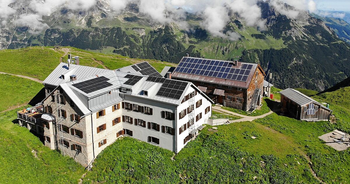
Rappensee Hut
building in Oberstdorf, Swabia, Germany
Geißfuß
The Geißfuß is a subpeak of Wegenköpfe in the Allgäu Alps in Bavaria, Germany.
Alpgundkopf
The Alpgundkopf is a mountain, 2,177 m high, in the Allgäu Alps. It lies in the Schafalpenköpfe group, northeast of the Roßgundkopf, from which it is separated by the Alpgundscharte col. To the southeast, 383 metres away, lies the lower Alpkopf and, 1,035 metres away, the small lake of Guggersee.
Grießgundkopf
Griesgundkopf is a minor elevation at the northeastern mountain shoulder of Alpgundkopf in the Allgäu Alps in Bavaria, Germany.
Bolsterlanger Horn
subpeak of Weiherkopf in the Allgäu Alps in Bavaria, Germany
Zeiger
ridge prominence of Wengenköpfe in the Allgäu Alps in Bavaria, Germany
Guggersee
The Guggersee is a small mountain lake in the Southeastern Walsertal Mountains (Südöstliche Walsertaler Berge), a subgroup of the Allgäu Alps.