Category
page 1Civil parishes in Cornwall

Truro
Truro (; ) is a cathedral city and civil parish in Cornwall, England. It is the southernmost city in the United Kingdom, and lies west-south-west of London. It is Cornwall's county town, only city, and a centre for administration, leisure and shopping. At the 2021 census the population of the parish was 21,046 and the population of the built up area as defined by the Office for National Statistics (which included the Gloweth and Treliske areas in the neighbouring parish of Kenwyn) was 23,060.

Penzance
Penzance ( ; ) is a town, civil parish and port in Cornwall, England. It lies west-southwest of Plymouth, west-southwest of London, and east of Land's End. Penzance railway station is the terminus of the Cornish Main Line and is both the southernmost and westernmost station in England. Situated in the shelter of Mount's Bay, the town faces south-east onto the English Channel. As well as Penzance itself, the parish also includes the fishing port of Newlyn and the villages of Mousehole, Paul, Gulval, and Heamoor. At the 2021 census the population of the parish was 20,734 and the population of th
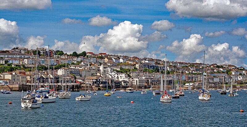
Falmouth
town and port on the River Fal in Cornwall, England, UK
St Ives
seaside town, civil parish and port in Cornwall, England
%20(9458675814).jpg)
Tintagel
Tintagel () or Trevena (, meaning Village on a Mountain) is a civil parish and village situated on the Atlantic coast of Cornwall, England, United Kingdom. The village and nearby Tintagel Castle are associated with the legends surrounding King Arthur and in recent times have become a tourist attraction. It was claimed by Geoffrey of Monmouth that the castle was the place of Arthur's conception.

Bodmin
Bodmin () is a town and civil parish in Cornwall, England, United Kingdom. It is situated south-west of Bodmin Moor.
St Michael's Mount
tidal island in Mount's Bay, Cornwall
St Austell
town in Cornwall, England, UK

Redruth
Redruth ( , ) is a town and civil parish in Cornwall, England. Redruth lies approximately at the junction of the A393 and A3047 roads, on the route of the old London to Land's End trunk road (now the A30), and is approximately west of Truro, east of St Ives, north east of Penzance and north west of Falmouth. At the 2021 census the population of the parish was 15,626 and the population of the built up area was 15,455.

Camborne
Camborne (, meaning "crooked hill") is a town and civil parish in Cornwall, England. At the 2021 census the population of the parish was 23,831 and the population of the built up area was 20,450. The town lies about inland, but the northern boundary of the parish is the coast, including Hell's Mouth and Deadman's Cove. The coast is followed by the South West Coast Path. As well as Camborne itself, the parish also includes a number of hamlets.
Penryn
town in Cornwall, England, UK

Saltash
Saltash () is a town and civil parish in eastern Cornwall, England. Saltash faces the city of Plymouth over the River Tamar and is popularly known as "the Gateway to Cornwall". Saltash’s landmarks include the Tamar Bridge which connects Plymouth to Cornwall by road, and the Royal Albert Bridge. At the 2021 census the population of the parish was 16,288 and the population of the built up area was 15,435.
Launceston
town, ancient borough, and civil parish in Cornwall, England, UK

Hayle
thumb|Sketch map showing Hayle and St Ives Bay
.jpg)
Padstow
Padstow (; ) is a town, civil parish and fishing port on the north coast of Cornwall, England, United Kingdom. The town is situated on the west bank of the River Camel estuary, approximately northwest of Wadebridge, northwest of Bodmin and northeast of Newquay. As well as Padstow itself, the parish also includes the village of Trevone and surrounding rural areas. At the 2021 census the population of the parish was 2,669 and the population of the built up area was 2,298.

Fowey
Fowey ( ; , meaning beech trees) is a port town and civil parish at the mouth of the River Fowey in south Cornwall, England, United Kingdom. The town has been in existence since well before the Norman invasion, with the local church first established some time in the 7th century; the estuary of the River Fowey forms a natural harbour which enabled the town to become an important trading centre. Privateers also made use of the sheltered harbourage. The Lostwithiel and Fowey Railway brought China clay here for export. At the 2021 census the population of the parish was 2,244 and the population o

Helston
Helston () is a town and civil parish in Cornwall, England. It is situated at the northern end of the Lizard Peninsula, approximately east of Penzance and south-west of Falmouth. Helston is the most southerly town on the island of Great Britain and is around farther south than Penzance. At the 2021 census, the population of the parish was 11,611 and that of the built up area was 11,360.

Lostwithiel
Lostwithiel (; ) is a town and civil parish in Cornwall, England, United Kingdom. It stands at the head of the estuary of the River Fowey. At the 2021 census, the population of the parish was 3,070. The name Lostwithiel comes from the Cornish "lostwydhyel" which means "tail of a wooded area".
St Mary's
UK island of the Isles of Scilly

Liskeard
Liskeard ( ; Lit. Lys court Kerr fort Ys wheat) is an ancient stannary and market town and civil parish in south-east Cornwall, England, United Kingdom. It is situated approximately 20 miles (32 km) west of Plymouth, west of the Devon border, and 12 miles (20 km) east of Bodmin. The Bodmin Moor lies to the north-west of the town. At the 2021 census the population of the parish of 10,902.

Looe
Looe (; , ) is a coastal town and civil parish in south-east Cornwall, England, United Kingdom. It lies west of Plymouth and south of Liskeard. At the 2021 census the parish had a population of 5,311.

Wadebridge
thumb|The Old Bridge
thumb|Looking towards the Methodist church from the bridge
%20by%20Sydney%20Hodges.jpg)
Torpoint
Torpoint () is a town and civil parish on the Rame Peninsula in southeast Cornwall, United Kingdom. It is situated opposite the city of Plymouth across the Hamoaze which is the tidal estuary of the River Tamar. At the 2021 census the parish had a population of 7,444 and the built up area had a population of 7,160.

Camelford
Camelford () is a town and civil parish in north Cornwall, England, United Kingdom, situated in the River Camel valley north-west of Bodmin Moor. The town is approximately north of Bodmin. The parish was historically called Lanteglos and was renamed Camelford after its largest settlement in 1934. As well as Camelford and the small village of Lanteglos, the parish also covers surrounding rural areas, including the hamlets of Helstone, Tregoodwell, and Trewalder. At the 2021 census the population of the parish was 3,378 and the population of the built up area was 2,926.

Marazion
thumb|Marazion from the east
St Just
town in west Cornwall, England, UK
Tresco
island in the Isles of Scilly

Callington
Callington () is a town and civil parish in east Cornwall, England. It lies about north of Saltash and south of Launceston. The parish had a population of 5,983 in 2021.
St Columb Major
town in Cornwall, England, UK

Porthleven
Porthleven (; ) is a town, civil parish and fishing port in Cornwall, England. The most southerly port in Great Britain, it was a harbour of refuge when this part of the Cornish coastline was infamous for wrecks in the days of sail. The South West Coast Path from Somerset to Dorset passes through the town. At the 2021 census, the population of the parish was 3,117.

St Germans
village and civil parish in Cornwall, England

Polperro
Polperro (, meaning ''Pyra's cove'') is a large village, civil parish, and fishing harbour within the Polperro Heritage Coastline in south Cornwall, England, United Kingdom. Its population is around 1,554.
.jpg)
Mevagissey
Mevagissey (; ) is a village, fishing port and civil parish in Cornwall, England, United Kingdom. The village is approximately five miles (8 km) south of St Austell. At the 2021 census the population of the parish was 2,160 and the population of the built up area was 1,749.

St Agnes
village and civil parish in Cornwall, England, UK

St Erth
village and civil parish in Cornwall, United Kingdom

Calstock
Calstock () is a civil parish and a large village in south east Cornwall, England, United Kingdom, on the border with Devon. The village is situated on the River Tamar south west of Tavistock and north of Plymouth.
Q1788486
island in United Kingdom
St Martin's
island in the Isles of Scilly, Cornwall, England, UK

Sennen
Sennen () is a coastal civil parish and a village in Cornwall, England, United Kingdom. Sennen village is situated approximately west-southwest of Penzance.

Crantock
thumb|St Carantoc's Church, Crantock

St Merryn
village in Cornwall, UK

Constantine
village and civil parish in Cornwall, England, UK
Portreath
Portreath () is a civil parish, village and fishing port on the north coast of Cornwall, England, United Kingdom. The village is about three miles (5 km) west-north-west of Redruth. The village extends along both sides of a stream valley and is centred on the harbour and beach. West of the harbour entrance and breakwater are two sandy beaches that are popular with holidaymakers, surfers and naturists.
.jpg)
Perranuthnoe
Perranuthnoe (; ) is a civil parish and a village in southwest Cornwall, England, United Kingdom. The parish population at the 2011 census was 2,184. The Parish includes the settlements of Goldsithney, Perran Downs, Perranuthnoe and part of Rosudgeon. The village of Perranuthnoe itself is situated on the east side of Mount's Bay approximately one mile (1.6 km) east of Marazion and four miles (6.5 km) east of Penzance.

Kilkhampton
thumb|right|St James' Church, Kilkhampton
thumb|right|Bevil Grenville's memorial, in Kilkhampton church

Menheniot
thumb|255px|Menheniot parish church
Menheniot (pronounced Men-en-yut; ) is a civil parish and village in Cornwall, England, United Kingdom. The village is southeast of Liskeard. The meaning of the name is "sanctuary of Neot" (from minihi and Neot).

St Dennis
village in Cornwall, England, UK

St Stephen-in-Brannel
village and civil parish in Cornwall, England, UK

Altarnun
Altarnun ( ; ) is a village and civil parish in Cornwall, England, United Kingdom. It lies west of Launceston on the north-eastern edge of Bodmin Moor at .

Mullion
village on the Lizard Peninsula in Cornwall, England, UK

St Erme
village in Cornwall, United Kingdom
Chacewater
Chacewater () is a village and civil parish in Cornwall, England, UK. It is situated approximately east of Redruth. The hamlets of Carnhot, Cox Hill, Creegbrawse, Hale Mills, Jolly's Bottom, Salem, Saveock, Scorrier, Todpool, Twelveheads and Wheal Busy are in the parish. At the 2011 census a population of 3,870 was quoted.

Cardinham
Cardinham () is a civil parish and a village in mid Cornwall, England. The village is approximately three-and-a-half miles (6 km) east-northeast of Bodmin. The hamlets of Fletchersbridge, Millpool, Milltown, Mount, Old Cardinham Castle and Welltown are in the parish.

Lanivet
Lanivet () is a village and civil parish in Cornwall, England, United Kingdom. The village is situated approximately southwest of Bodmin, and before the Bodmin by-pass was built, the A30 road between London and Land's End passed through the village. The Saints' Way long-distance footpath passes Lanivet near its half-way point.

Perranzabuloe
Perranzabuloe (; ) is a coastal civil parish and a hamlet in Cornwall, England. Perranzabuloe parish is bordered to the west by the Atlantic coast and St Agnes parish, to the north by Cubert parish, to the east by St Newlyn East and St Allen parishes and to the south by Kenwyn parish. The hamlet (containing the parish church) is situated just over a mile (2 km) south of the principal settlement of the parish, Perranporth; the hamlet is also south-southwest of Newquay. Other settlements in the parish include Perrancoombe, Goonhavern, Mount and Callestick. The parish population was 5,382 in

St Keverne
village in Cornwall, England, UK

Lanreath
Lanreath () is a civil parish and a village in southeast Cornwall, England, United Kingdom. The village is situated five miles (8 km) west-northwest of Looe. The name Lanreath (pronounced Lanreth) means 'church (Lann) of Raydhogh' and it has been known variously as Lanreythow, Lanrathew, or Lanrethou. The village is mentioned in the Domesday Book as Lanredoch.

St Levan
village in Cornwall, England, United Kingdom
Antony
village and civil parish in Cornwall, England, UK

Millbrook
civil parish and village in Cornwall, England