Category
page 1Glockner Group
.png)
Grossglockner
The Großglockner ( ), or just Glockner, is, at 3,798 metres above the Adriatic (12,461 ft), the highest mountain in Austria and highest mountain in the Alps east of the Brenner Pass. It is part of the larger Glockner Group of the Hohe Tauern range, situated along the main ridge of the Central Eastern Alps and the Alpine divide. The Pasterze, Austria's most extended glacier, lies on the Grossglockner's eastern slope.

Kaprun
Kaprun () is a municipality in the Zell am See District in the province of Salzburg in Austria. Together with the neighboring city of Zell am See the town presents itself as the tourist destination and skiing area "Zell am See-Kaprun". Kaprun distinguishes itself from its larger neighbor at the lake, by offering all year access to the Kitzsteinhorn with its Top of Salzburg viewing platform at altitude and its glacier ski area that is open October through May.
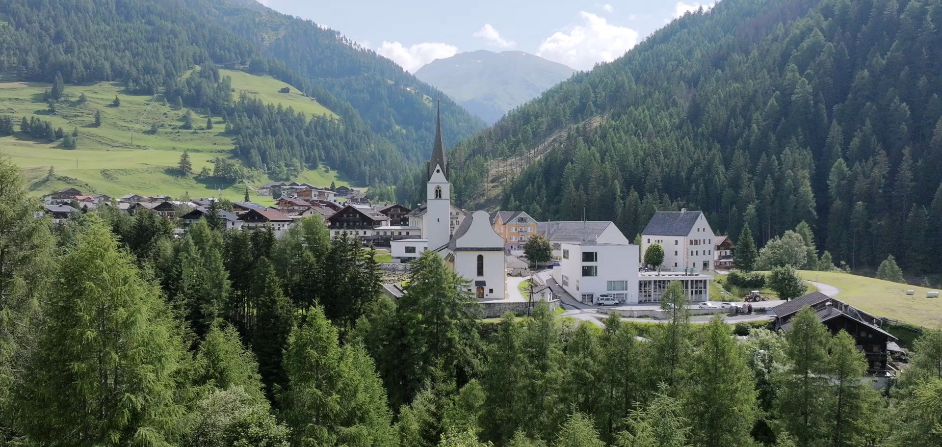
Heiligenblut
municipality in Spittal an der Drau District, Carinthia, Austria
Kals am Großglockner
municipality in Lienz District, Tyrol, Austria

Rauris
Rauris is a municipality in Salzburg (state) in the area of Pinzgau in Austria. There are about 3,150 inhabitants living in Rauris.
Uttendorf
Uttendorf is a municipality in the district of Zell am See (Pinzgau region), in the state of Salzburg in Austria.
Fusch an der Großglocknerstraße
municipality in Zell am See District, Salzburg, Austria
Taxenbach
Taxenbach is a market town in the district of Zell am See (Pinzgau region), in the state of Salzburg in Austria.
Niedernsill
Niedernsill () is a town located in the Zell am See district in the state of Salzburg in Austria. It is best known for its winter sports of skiing and its summer activities of hiking.
Bruck an der Großglocknerstraße
municipality in Zell am See District, Salzburg, Austria
Pasterze Glacier
glacier in Austria

Kitzsteinhorn
The Kitzsteinhorn is a mountain in the High Tauern range of the Central Eastern Alps in Austria. It is part of the Glockner Group and reaches a height of AA. The Kitzsteinhorn Glaciers are a popular ski area.
Großes Wiesbachhorn
mountain in the Glockner Group in Salzburg
Glocknerwand
The Glocknerwand () is a mountain in the Glockner Group in the Austrian Central Alps in the central region of the High Tauern. According to the literature it is 3,721 metres high, but the Austria Federal Office for Metrology and Survey gives its height as 3,722 metres. It is separated from Austria's highest peak, the neighbouring Großglockner, by the col known as the Untere Glocknerscharte (3596 m). The mountain lies on the boundary between East Tyrol and Carinthia.
Hoher Tenn
mountain in the Glockner Group in Salzburg
Johannisberg
mountain in the Glockner Group at the border Carinthia / Salzburg
Kleinglockner
At the height of the Kleinglockner is the third highest mountain summit in Austria. However, with a prominence of only 17 metres it is arguable whether it can be counted as an independent mountain, or just as a subpeak of the Großglockner. It lies in the Glockner Group of Austria's Central Alps, the middle section of the Hohe Tauern. Geographically and geologically speaking, it is viewed a secondary summit of the neighbouring Großglockner, but in the literature, in view of its importance to mountaineering, it is in some cases treated as separate. Its peak forms part of the Glockner crest or ri

Glockner Group
mountain range
Q664834
The Fuscherkarkopf, sometimes also written Fuscher-Kar-Kopf in German and formerly also called the Fuschereiskarkopf, is one of the twin peaks of a mountain in the Glockner Group in the centre of the main mountain chain (Mittleren Tauernhauptkamm) in the High Tauern, a range in the Austrian Central Alps. The mountain lies right on the border between the Austrian states of Salzburg and Carinthia. The main peak is 3,331 metres high, but the northwest summit is only 3,252 metres high. The two peaks are about 500 metres apart and linked by a curved firn-covered ridge. Further sharp, prominent ridg
Hohe Dock
mountain
Hinterer Bratschenkopf
mountain in the Glockner Group in Salzburg

Großer Bärenkopf
mountain in the Glockner Group at the border Carinthia / Salzburg
Klockerin
The Klockerin, formerly also called the Glockerin or Glocknerin, is a twin-peaked mountain in the Glockner Group on the ridge of Fuscher/Kapruner Kamm in the High Tauern, a range within the Central Alps in the Austrian state of Salzburg. Its southwest top (Südwestgipfel) is high, its northeast top (Nordostgipfel) has a height of 3,335 m. The two summits are about 240 metres apart. A prominent arête runs westwards; the west-northwestern arête is a short, but knife-edge ridge of rock. The Klockerin has a mighty Northwest Face which is 920 metres high and has a gradient of 54°. The mountain
Eiskögele
The Eiskögele is a mountain in the Glockner Group in the western part of the main Tauern chain, a range of the Austrian Central Alps. It lies right on the border between the Austrian states of Salzburg, Carinthia and East Tyrol and thus forms a tripoint. The mountain has the shape of an ice-covered horn with a mighty North Face, a prominent Northeast Ridge (Nordostgrat) and a sharp firn edge (Firnschneide) to the west. From its base, the Oberwalder Hut, it is easy to reach via the Pasterzeboden glacier. It was first climbed on 30 July 1872 by the tourist B. Lergetporer from Schwaz and mountain
Teufelshorn
mountain in the Glockner Group at the border Salzburg / East Tyrol
Racherin
The Racherin, a mountain with a height of , lies in the Glockner Group in the High Tauern range in Austria. The summit is located ca. 6 km, as the crow flies, northwest of Heiligenblut in the state of Carinthia. The unmarked and mostly trackless normal route is not difficult in snow-free and dry conditions, but is rather laborious. An ascent therefore requires a good sense of direction. In suitable weather there are good views from the top, including an impressive view of the Großglockner and the surrounding mountain world.
Fuscher Ache
river in the Glockner Group in Salzburg, tributary of Salzach
Edelweißspitze
The '''' is a summit in High Tauern, located in Salzburg, Austria north of the Alpine divide. It can be accessed by car from Edelweißstraße, a branch-off from Grossglockner High Alpine Road, starting from Fuscher Törl and is the highest-accessible point of the road. Originally, its height was 2577m before building the parking lot and was named Poneck, Leitenkogel or Bergerkogel''. It serves as a scenic viewpoint of the High Tauern National Park with views to summits of the Glockner Group. In north-west direction, there is a hut which includes a restaurant.
Hocheiser
Hocheiser (3,206m) is a mountain in the Glockner Group of the High Tauern in the state of Salzburg, Austria.
Kaiser-Franz-Josefs-Höhe
thumb|View of Kaiser-Franz-Josefs-Höhe
Stausee Margaritze
lake in Austria