Category
page 1Karoo

Northern Cape
province of South Africa

Orange River
major river of southern Africa

Karoo
The Karoo ( ; from Khoikhoi (also known as Khoekhoegowab/Namagowab or Hottentot language) word ) is a semidesert natural region of South Africa. No exact definition of what constitutes the Karoo is available, so its extent is also not precisely defined. The Karoo is partly defined by its topography, geology and climate, and above all, its low rainfall, arid air, cloudless skies, and extremes of heat and cold. The Karoo also hosted a well-preserved ecosystem hundreds of millions of years ago which is now represented by many fossils.

Orania

Riverine rabbit
species of mammal

Graaff-Reinet
Graaff-Reinet (; Xhosa: eRhafu; Khoe: !Xamdubu), officially Robert Sobukwe Town after a name change in February 2026, is a town in the Eastern Cape Province of South Africa. It is the oldest town in the province and the sixth oldest town in South Africa, after Cape Town, Stellenbosch, Simon's Town, Paarl and Swellendam. The town was the centre of a short-lived republic in the late 18th century before being annexed into the Cape Colony. The town was a starting point for Great Trek groups led by Gerrit Maritz and Piet Retief and furnished large numbers of the Voortrekkers in 1835–1842.

Oudtshoorn
Oudtshoorn (, ) is a town in the Western Cape province of South Africa, located between the Swartberg mountains to the north and the Outeniqua Mountains to the south. Dubbed the "ostrich capital of the world", Oudtshoorn is known for its ostrich-feather booms, during 1865–1870 and 1900–1914. With approximately 60,000 inhabitants, it is the largest town in the Klein Karoo region. The town's economy is primarily reliant on the ostrich farming and tourism industries. Oudtshoorn is home to the world's largest ostrich population, with a number of specialised ostrich breeding farms, such as the Safa
.jpg)
veld
thumb|upright=1.3|Typical veld near Petrified forest, Khorixas|Petrified forest in [[Namibia]]
thumb|Springbok in growing veld; [[Etosha National Park, Namibia]]
thumb|Springboks in the burned veld; Etosha National Park, Namibia
Beaufort West
town in the Western Cape, South Africa
ǀXam
extinct language of South Africa and Lesotho

Cradock
Nxuba, formerly Cradock, is a town in the Eastern Cape Province of South Africa, in the upper valley of the Great Fish River, by road northeast of Gqeberha. The town is the administrative seat of the Inxuba Yethemba Local Municipality in the Chris Hani District of the Eastern Cape.
Southern African Large Telescope
9.2-metre optical telescope operated by the South African Astronomical Observatory

Karoo Chat
species of bird
De Aar
town in the Northern Cape, South Africa

Colesberg
Colesberg is a town with 17,354 inhabitants in the Northern Cape province of South Africa, located on the main N1 road from Cape Town to Johannesburg.

Namaqualand
thumb|right|A waterfall situated a few kilometres north of [[Nieuwoudtville on the road to Loeriesfontein, in the Northern Cape (Namaqualand region)]]
thumb|Namaqualand, outside of the flower season
thumb|right|The spring flowers in Namaqualand

Swartberg
The Swartberg mountains (black mountain in English) are a mountain range in the Western Cape province of South Africa. It is composed of two main mountain chains running roughly east–west along the northern edge of the semi-arid Little Karoo. To the north of the range lies the other large semi-arid area in South Africa, the Great Karoo. Most of the Swartberg Mountains are above 2000 m high, making them the tallest mountains in the Western Cape. It is also one of the longest, spanning some 230 km from south of Laingsburg in the west to between Willowmore and Uniondale in the east. Geologic
Middelburg
town in the Eastern Cape, South Africa
Sarah Baartman District Municipality
district municipality in the Eastern Cape, South Africa
Central Karoo District Municipality
district municipality in the Western Cape, South Africa
Prince Albert
town in the Western Cape, South Africa
Laingsburg
town in the Western Cape, South Africa
Karoo National Park
national park in South Africa

Kakamas
Kakamas is a town founded in 1898 and located in the Northern Cape province of South Africa, on the banks of the Orange River.
Battle of Magersfontein
1899 battle of the Second Boer War
Prieska
Prieska is a town on the south bank of the Orange River, in the province of the Northern Cape, in western South Africa. It is located on the southern bank of the Orange River, 130 km north-west of Britstown and 75 km south-east of Marydale.
Wilhelm Heinrich Immanuel Bleek
German linguist (1827-1875)

Karoo Thrush
species of bird
Carnarvon
town in the Northern Cape, South Africa
Pixley ka Seme District Municipality
district municipality in the Northern Cape, South Africa
Sutherland
place in Northern Cape, South Africa
Karoo Ice Age
glaciation
De Rust
village in the Western Cape, South Africa
Pofadder
town in the Northern Cape, South Africa
Calvinia
Calvinia is a regional town in the Northern Cape province of South Africa named after the French religious reformer Jean Calvin. The town falls under the Hantam Local Municipality which forms part of the Namakwa District Municipality. The Calvinia district is part of the Great Karoo region of South Africa. The town is just south of the Hantam mountains on the banks of the Oorlogskloof (meaning "War Ravine") River.
Koffiefontein
Koffiefontein is a small farming town in the Free State province of South Africa. The name means coffee fountain in Afrikaans.

Aggeneys
thumb|An unusual specimen of Aggeneys chalcopyrite (golden) and [[magnetite (dark), the latter well-crystallized in truncated octahedrons up to 1 cm.]]
Aggeneys is a mining town established in 1976 on a farm of that name, situated between Pofadder and Springbok in the Northern Cape, South Africa.

Hopetown
Hopetown is a town which lies at the edge of the Great Karoo in South Africa's Northern Cape province. It is situated on an arid slope leading down to the Orange River. Two of the largest diamonds discovered in South Africa, the Eureka Diamond and the Star of Africa were found at Hopetown between 1867 and 1869
Victoria West
human settlement in South Africa

Fraserburg
Fraserburg is a town in the Karoo region of South Africa's Northern Cape province. It is located in the Karoo Hoogland Local Municipality. The town has some of the coldest winters in South Africa.
Philippolis
Philippolis is a town in the Free State province of South Africa. The town is the birthplace of writer and intellectual Sir Laurens van der Post, actress Brümilda van Rensburg and Springboks rugby player Adriaan Strauss. It is regarded as one of the first colonial settlements in the Free State.

Nieu-Bethesda
Nieu-Bethesda (Afrikaans for New Bethesda) is a village in the Eastern Cape at the foot of the Sneeuberge, approximately north of Graaff Reinet. It was founded in 1875 as a church town, like many other Karoo villages, and attained municipal status in 1886.
Uniondale
place in Western Cape, South Africa
Prince Albert Local Municipality
local municipality in the Western Cape, South Africa
Jagersfontein
Jagersfontein is a small town in the Free State province of South Africa.
%20(14761334056).jpg)
Sneeuberge
thumb|right|340px|Descending from the Snow Mountains, a scene near Graaff-Reinet, by William Burchell
Inxuba Yethemba Local Municipality
local municipality in the Eastern Cape, South Africa

Endothiodon
Endothiodon (/ɛndoʊθiːoʊdɔːn/ "inner tooth" from Greek endothi (ἔνδοθῐ), "within", and odon (ὀδών), "tooth", most likely named for the characteristic of the teeth being placed internally to the maxilla) is an extinct genus of medium to large dicynodont from the Late Permian. Like other dicynodonts, Endothiodon was an herbivore, but it typically lacked the two tusks that characterized most other dicynodonts and instead had long rows of teeth inset in the jaws that replaced in waves. The anterior portion of the upper and lower jaw are curved upward, creating a distinct beak that is thought to ha
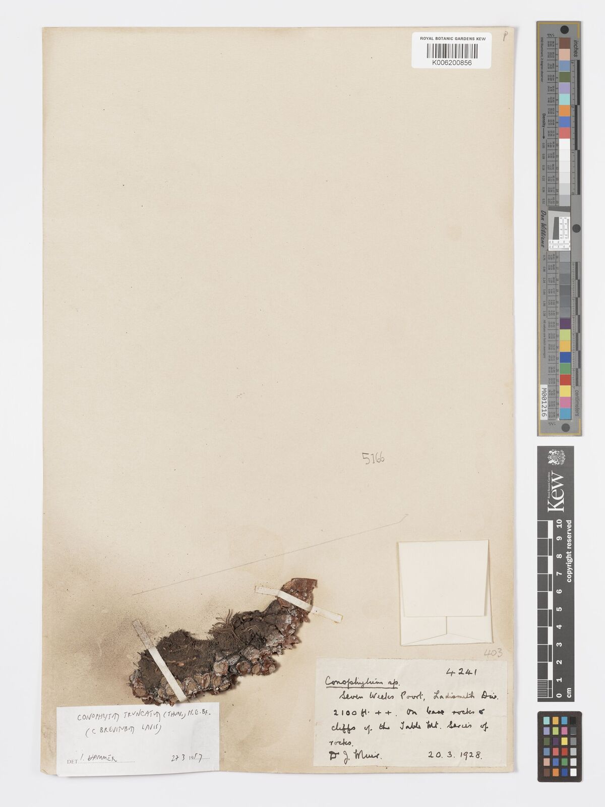
Conophytum truncatum
species of plant
Williston
town in the Northern Cape, South Africa

Brandvlei
Brandvlei is a small town in the Karoo region of the Northern Cape, South Africa. This is where a 19th-century trekboer called Ou Brand settled. Brand camped at this spot at the Sakrivier, a dry river bed, which only occasionally had water after good rains – and which typically result in flash floods. The settlement was cut in two by such a flood in 1961. After it was recovered, a municipality was formed in 1962.
Laingsburg Local Municipality
local municipality in the Western Cape, South Africa
Karoo Supergroup
stratigraphic unit in sub-Saharan Africa
Modder River
river in South Africa

Britstown
Britstown is a small farming town situated in the Northern Cape province of South Africa, in the Pixley ka Seme District Municipality, Emthanjeni Local Municipality. The town is named after Hans Brits who settled here after he accompanied David Livingstone on a venture into the interior.

Kareeberg Local Municipality
local municipality in the Northern Cape, South Africa

Nama Karoo
xeric shrubland ecoregion on the central plateau of South Africa and Namibia

Loeriesfontein
Loeriesfontein is a small town in the Northern Cape of South Africa. It falls within what is known as the Hantam region.
thumb|right|500px|The 27 water-pumping windmills on display in Loeriesfontein – see the figure at the left for a sense of scale.
== The town ==
=== Location ===
Beaufort West Local Municipality
local municipality in the Western Cape, South Africa
Jacobsdal
Jacobsdal is a small farming town in the Free State province of South Africa with various crops under irrigation, such as grapes, potatoes, lucerne, and groundnuts. The town was laid out in 1859 by Christoffel Jacobs on his farm Kalkfontein, and the population was 3,504 in 2011.