Category
page 1Landforms of Achaea
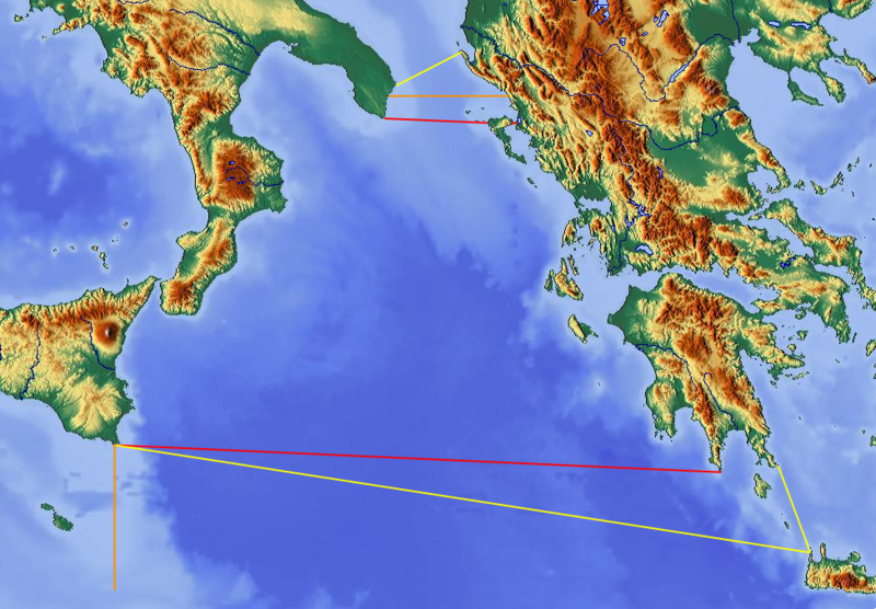
Ionian Sea
an elongated bay of the Mediterranean Sea, south of the Adriatic Sea, bounded by Southern Italy (Calabria, Sicily, Salento peninsula) to the west, southern Albania to the north, and the west coast of Greece to the east

Gulf of Corinth
gulf of the Ionian Sea, separating Peloponnese from Central Greece
Gulf of Patras
bay of Ionian Sea in Greece
Mount Erymanthos
mountain in Erymanthos municipality, Greece
Pineios
river in the western Peloponnese, Greece
Aroania
mountain range in northern Peloponnese, Greece
Ladon
river in Peloponnese, Greece
Erymanthos
river in Peloponnese, Greece

Aroanios
thumb|250px|View of the landscape near Aroanios' River, karst springs
thumb|250px|Karst spring. After 600m: 41 small karst spring outlets make an enormous water amount
thumb|250px|naturally watered forest of Platanus orientalis|platanus trees in [[sand and gravel]]
thumb|250px|Buildings, abandoned, are standing directly in the fragile nature
Panachaiko
The Panachaiko (, "Panachaean"), also known as Vodias (Βοδιάς) mainly at the Middle Ages, is a mountain range in Achaea, Peloponnese, Greece. It spans about 20 km in length from north to south, and 15–20 km from east to west. It is the northernmost mountain range in the Peloponnese. The highest point, named Pyrgos Palavou (Πύργος Παλαβού), is .
Glafkos
river in Achaea, Peloponnese, Greece
Peiros
The Peiros (, formerly also Kamenitza and Achelous) is a river in the central and the northwestern parts of Achaea, Greece. It is long.
Charadros
The Charadros () is a river in the northern part of Achaea, Greece. Its course lies entirely within the municipality of Patras. It is long.
Larissos
river in Western Greece
Krathis
The Krathis (, ) is a river in the eastern part of Achaea, southern Greece. The river flows through the municipal unit of Akrata. It is long.
Skollis
thumb|280px|Santameri (Skollis) mountain
thumb|left|280px|Mt. Skollis
Skollis (), also known as Santameri, is a mountain in southwestern Achaea in the Peloponnese in western Greece. Its elevation is . It is situated between the villages Santomeri to the north and Portes to the south.
Selinountas
river in Achaea, Peloponnese, Greece
Cave of the Lakes
cave in Achaea, Peloponnese, Greece
Selemnos
Selemnos (Ancient Greek: Σέλεμνος, ) is a river in the northern part of Achaea, Greece. The river flows entirely in the municipal unit of Rio and empties into the Gulf of Corinth.
Movri
Movri () is a forested mountain range in western Achaea, Greece. Its highest point is 719 m amsl. It covers part of the municipal units Movri (named after this mountain), Dymi, Larissos and Olenia, all in the municipality of West Achaea. It is located about 30 km southwest of Patras. The higher mountain range Skollis lies to its southeast. The river Larissos has its source in the Movri, and flows to the west.
Krios
river of Achaia, Greece
Omplos
Omplos () is a mountain in Achaea, Greece. It rises steeply from the coastal plains around Patras to 926 m elevation. It is separated from the higher mountain Panachaikos by the valley of the river Glafkos. The summit is 2 km west of the village Petroto, 4 km east of Kallithea, 4 km southeast of Saravali and 10 km southeast of Patras city centre.
Parapeiros
thumb|right|260px|Asteri Dam or Parapiros Dam. View of the dam lake. The temporary islet with Saint Theodores' chapel of Mitopolis village sinking.
The Parapeiros (, also Τυθεύς - Tythefs, - Teutheas) is a river in the western part of Achaea, Greece. It is long. The Parapeiros begins in the western part of the Erymanthos mountains close to Alepochori. It passes through the municipal units of Tritaia and Farres. It empties into the river Peiros near the village Agios Stefanos.
Volinaios
The Volinaios (, also Δρεπανέικο Drepaneiko, ) is a river in the northern part of Achaea, Greece. It empties into the Gulf of Corinth. The river is named after the ancient town of Boline. The river begins in the northern part of the Panachaiko mountains, it flows through the village Drepano where it has water all year round. The river flows into the Gulf of Corinth near Psathopyrgos.
Mount Barbas
mountain in Erymanthos municipality, Greece