Category
page 1Satellite series
Vela
group of satellites
Corona
series of American strategic reconnaissance satellites
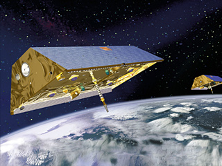
Gravity Recovery and Climate Experiment
joint mission of NASA and the German Aerospace Center
Zenit
series of Soviet spy satellites
SPOT
series of Earth observation satellites
Nilesat
Egyptian Satellites Co SAE or Nilesat (; or , ) is a company and the name of a series of Egyptian communications satellites. It was established in 1996 by the government of Egypt with the purpose of operating Egyptian satellites and their associated mission control center and ground stations. The company is now listed on the Egyptian Exchange, though remains controlled by the government (c.75%) through the National Media Authority (40%), and other state-owned enterprises (SOEs).
Earth Observing System
program of NASA comprising a series of artificial satellite missions and scientific instruments in Earth orbit

LAGEOS
thumb|upright|The LAGEOS plaque, designed by Carl Sagan|left
LAGEOS (), Laser Geodynamics Satellite or Laser Geometric Environmental Observation Survey, are a series of two scientific research satellites designed to provide an orbiting laser ranging benchmark for geodynamical studies of the Earth. Each satellite is a high-density passive laser reflector in a very stable medium Earth orbit (MEO).
Molniya
Soviet communications satellite
Television Infrared Observation Satellite
series of American weather satellites
Nimbus program
second-generation U.S. robotic spacecraft

Elektro–L
Elektro–L () is a series of meteorological satellites developed for the Russian Federal Space Agency by NPO Lavochkin. The first satellite, Elektro-L No.1, was launched on 2 January 2011. It is the first Russian weather satellite that successfully operates in geostationary orbit, and is currently the second operational Russian weather satellite. The satellites have a mass of about 1620 kg and are designed to operate for 10 years each. They are capable of producing images of the Earth's whole hemisphere in both visible and infrared frequencies, providing data for climate change and ocean m
Elektron
satellite

Syncom
thumb|Artist's vision of Syncom satellite, 1963
Syncom (for "synchronous communication satellite") started as a 1961 NASA program for active geosynchronous communication satellites, all of which were developed and manufactured by the Space and Communications division of Hughes Aircraft Company (now the Boeing Satellite Development Center). Syncom 2, launched in 1963, was the world's first geosynchronous communications satellite. Syncom 3, launched in 1964, was the world's first geostationary satellite.
Meteor
satellite
Proton
Soviet satellite model
.png)
Yaogan satellites
Yaogan () is the designation used by the People's Republic of China to refer to its military reconnaissance satellites. Yaogan satellites are largely known to primarily support the People's Liberation Army's Strategic Support Force (PLASSF), formerly the Aerospace Reconnaissance Bureau of the Second Department of the General Staff. The Yaogan program is the successor to the Fanhui Shi Weixing (FSW) recoverable reconnaissance satellite program but, unlike its predecessor, includes a variety of classes utilizing various means of remote sensing such as optical reconnaissance, synthetic-aperture r
Anik
series of Canadian geostationary communications satellites
Defense Meteorological Satellite Program
monitoring program for the Department of Defense

Sentinel-3
Sentinel-3 is an Earth observation heavy satellite series developed by the European Space Agency as part of the Copernicus Programme. As of 2024, it consists of 2 satellites: Sentinel-3A and Sentinel-3B. After initial commissioning, each satellite was handed over to EUMETSAT for the routine operations phase of the mission. Two recurrent satellites, Sentinel-3C and Sentinel-3D, will follow in approximately 2026 and 2028 respectively to ensure continuity of the Sentinel-3 mission.
thumb|305x305px|Model of Sentinel-3
Each Sentinel-3 satellite is designed to operate for seven years in a sun-synchr

MetOp
MetOp (Meteorological Operational satellite) is a series of three polar-orbiting meteorological satellites developed by the European Space Agency (ESA) and operated by the European Organisation for the Exploitation of Meteorological Satellites (EUMETSAT). The satellites form the space segment component of the overall EUMETSAT Polar System (EPS), which in turn is the European half of the EUMETSAT / NOAA Initial Joint Polar System (IJPS). The satellites carry a payload comprising 11 scientific instruments and two which support Cospas-Sarsat Search and Rescue services. In order to provide data co

Lacrosse
series of American reconnaissance satellites
EROS
Israeli commercial Earth observation satellite series

KOMPSAT
thumb | right | An artist rendering of the KOMPSAT-1
KOMPSAT or Korean Multi-Purpose Satellite is a series of South Korean multipurpose satellite for Earth observation, communications, meteorological, environmental, agricultural, and oceanographic monitoring applications.
KH-11 KENNEN
family of American reconnaissance satellites
Telstar
thumb|thumbtime=35|Universal newsreel about Telstar 1
Information Gathering Satellite
Japanese spy satellite program
Gaofen
Gaofen () is a series of Chinese high-resolution Earth imaging satellites launched as part of the China High-resolution Earth Observation System (CHEOS) program. CHEOS is a state-sponsored, civilian Earth-observation program used for agricultural, disaster, resource, and environmental monitoring. Proposed in 2006 and approved in 2010, the CHEOS program consists of the Gaofen series of space-based satellites, near-space and airborne systems such as airships and UAVs, ground systems that conduct data receipt, processing, calibration, and taskings, and a system of applications that fuse observati
Jilin 1
Jilin-1 () is China's first self-developed commercial remote sensing satellite system. The satellites are operated by Chang Guang Satellite Technology Corporation and named after Jilin Province where the company is headquartered. The first set of satellites were launched by Long March 2D in Jiuquan Satellite Launch Center on 7 October 2015, at 04:13 UTC. All launched Jilin-1 satellites are in Sun-synchronous orbit (SSO).
SAMOS
American reconnaissance satellite series
Nimiq
The Nimiq satellites are a Canadian fleet of geostationary telecommunications satellites owned by Telesat and used by satellite television providers including Bell Satellite TV and EchoStar (Dish Network). 'Nimiq' is an Inuit word used for an object or a force which binds things together. A contest in 1998 was held to choose the name of these satellites. The contest drew over 36,000 entries. Sheila Rogers, a physiotherapist from Nepean, Ontario, submitted the winning name.
Naval Ocean Surveillance System
series of signals intelligence satellites of the U.S. Navy
Shijian
thumb|313x313px|Shijian-23 prior to launch from Wenchang SLC
Shijian (, abbr. "SJ") is a series of satellites built and operated by the People's Republic of China. Some Shijian-series satellites have drawn significant concerns from the United States government and space observers who cite unannounced launches, undisclosed sub-satellites deployed in orbit, unusual orbital maneuvers, and demonstrated rendezvous proximity operations (RPO) including the close inspection and towing of other satellites.
Bhaskara
satellite
Lincoln Experimental Satellite
series of experimental satellites built by Lincoln Laboratory
HaiYang
series of Chinese marine remote sensing satellites
Ziyuan
series of Chinese satellites
Shiyan
Chinese satellite program
Tongxin Jishu Shiyan
Chinese military satellite program operating in geostationary orbit
Tactical Satellite Program
series of satellites
Radar Imaging Satellite
RISAT (Radar Imaging Satellite) is a series of Indian radar imaging reconnaissance satellites built by the Indian Space Research Organization (ISRO). They provide all-weather surveillance using synthetic aperture radars (SAR).
Starshine
series of satellites
MetOp-SG
MetOp-SG (Meteorological Operational Satellite – Second Generation) is a series of six meteorological satellites developed by European Space Agency and EUMETSAT to be launched from 2025 to 2039.
Satélite de Coleta de Dados
Brazilian satellites abbreviated SCD-1 and SCD-2
Samos-F
thumb|250x250px|Launch of SAMOS F2-3 (Ferret 2) on 1963-01-16
SAMOS-F or Air Force Program 102 refers to a series of SIGINT reconnaissance satellites launched and operated by the United States Air Force and National Reconnaissance Office during the 1960s. Initial priorities (in decreasing order) were to monitor radio waves in the frequency bands 2.5-3.2 GHz (S band), 9.0–10 GHz (X band), and 59-650 MHz. The intercepted data and their location were stored on magnetic tape, and subsequently transmitted to tracking and acquisition ground stations. Tracking stations were located in
Tianhui
family of chinese Earth observation satellites