Category
page 1Coastal and oceanic landforms

sea
thumb|Mediterranean Sea|The Mediterranean Sea, an enclosed sea flowing into the [[Atlantic Ocean]]
A sea is a large body of salt water. There are particular seas and the sea. The sea commonly refers to the ocean, the interconnected body of seawaters that spans most of Earth. Particular seas are either marginal seas, second-order sections of the oceanic sea (e.g. the Mediterranean Sea), or certain large, nearly landlocked bodies of water.

ocean
The ocean is the body of salt water that covers approximately 70.8% of Earth. The ocean is conventionally divided into large bodies of water, which are also referred to as oceans (in descending order by area: the Pacific Ocean, the Atlantic Ocean, the Indian Ocean, the Antarctic/Southern Ocean, and the Arctic Ocean), and are themselves mostly divided into seas, gulfs and subsequent bodies of water. The ocean contains 97% of Earth's water and is the primary component of Earth's hydrosphere, acting as a huge reservoir of heat for Earth's energy budget, as well as for its carbon cycle and water c

island
alt=A satellite view of the Hawaiian islands, with the top of the image being North. There are few clouds, and most of the image is the seawater swirling in the wind, surrounding the islands.|thumb|upright=1.3|The Hawaiian Islands, a major archipelago in the [[Pacific Ocean]]
An island or isle is a piece of land, distinct from a continent, completely surrounded by water. There are continental islands, which were formed by being split from a continent by plate tectonics, and oceanic islands, which have never been part of a continent. Oceanic islands can be formed from volcanic activity, grow in

archipelago
thumb|upright=1.6|The Indonesian Archipelago, located in Asia and [[Oceania, is the largest archipelagic state in the world.]]
thumb|upright|The Aegean Sea with its large number of islands is the origin of the term archipelago.
thumb|The Mergui Archipelago in Myanmar
An archipelago ( ), sometimes called an island group or island chain, is a chain, cluster, or collection of islands. An archipelago may be in an ocean, a sea, or a smaller body of water. Examples of archipelagos include the Aegean Islands (the origin of the term), the Canadian Arctic Archipelago, the Stockholm Archipelago, the Mal

beach
A beach is a landform alongside a body of water which consists of loose particles. The particles composing a beach are typically made from rock, such as sand, gravel, shingle, pebbles, etc., or biological sources, such as mollusc shells or coralline algae. Sediments settle in different densities and structures, depending on the local wave action and weather, creating different textures, colors and gradients or layers of material.

strait
thumb|upright=1.15|Strait of Gibraltar
thumb|Diagrammatic map of a strait

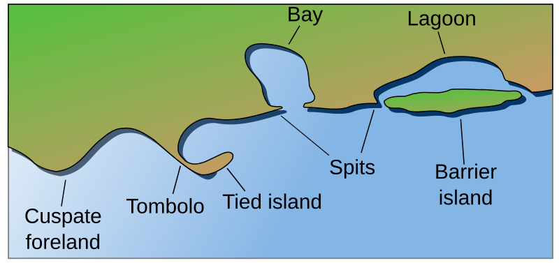
bay
thumb|Bay at Castletown, Isle of Man
thumb|Bay of Baracoa, Cuba

atoll
thumb|The atoll of Tetiʻaroa in [[French Polynesia]]

lagoon
thumb| Balos coastal lagoon of northwestern Crete. The shallow lagoon is separated from the Mediterranean Sea by narrow shoals connecting to a small, rocky mountain.
thumb|Garabogazköl lagoon in [[Turkmenistan]]
thumb|Venetian Lagoon
coast
thumb|Sunrise on the [[Jersey Shore coastline at Spring Lake, New Jersey, U.S.]]
thumb|Rugged coastline of the West Coast, New Zealand|West Coast Region of New Zealand
A view of the plain near Dikili in Turkey|thumb
thumb|Southeast coast of Greenland
thumb|Escorca coast, [[Serra de Tramuntana (Balearic Islands)]]

coral reef
ridge of rock in the sea formed by the growth and deposit of coral

fjord
thumb|Geirangerfjord, [[Norway]]
In physical geography, a fjord (also spelled fiord, a variant most common in New Zealand English; ) is a long, narrow sea inlet with steep sides or cliffs in a valley created by a former glacier, which has since become inundated with water. They are the glacial equivalent of drowned river valleys, known as rias. Fjords exist on the coasts of Antarctica, the Arctic, and surrounding landmasses of the northern and southern hemispheres. Areas with extensive fjords demonstrate an extreme example of the coastline paradox; Norway's coastline is estimated to be long wi

dune
400px|thumbnail|The Maspalomas Dunes of [[Gran Canaria, Canary Islands, Spain]]

estuary
thumb|Río de la Plata estuary
thumb|Mattole River estuary

cliff
thumb|The White Cliffs of Dover
upright|thumb|The Trango Towers in Pakistan. Their vertical faces are the world's tallest cliffs. Trango Tower center; Trango Monk center left; Trango II far left; Great Trango right.
upright|thumb|Europe's highest cliff, Troll Wall in Norway, a famous [[BASE jumping location for jumpers from around the world.]]

cape
headland of large size extending into a body of water, usually the sea

continental shelf
portion of a continent that is submerged under an area of relatively shallow water known as a shelf sea

reef
thumb|Coral reef at Nusa Lembongan, Bali, Indonesia
thumb|Pamalican island with surrounding reef, [[Sulu Sea, Philippines]]
thumb|A reef surrounding an islet
thumb|Reefs off Vanatinai|Vanatinai Island in the [[Louisiade Archipelago]]
mid-ocean ridge
basaltic underwater mountain system formed by plate tectonic spreading

oceanic trench
depressions of the sea floor

islet
thumb|Rockall, an islet located west of Ireland and Scotland
thumb|Bàngchuí Island in Dalian, [[Liaoning, China, is a typical rock islet]]
right|thumb|Mōkōlea Rock in Kailua Bay, [[O‘ahu, off North Beach, Marine Corps Base Hawaii]]

shoal
right|thumb|Sandbar between St. Agnes, Isles of Scilly|St Agnes and [[Gugh on the Isles of Scilly, off the coast of Cornwall, England, United Kingdom]]
thumb|A tidal sandbar connecting the islands of Waya Island|Waya and Wayasewa of the [[Yasawa Islands, Fiji]]
thumb|Sandbar between Nosy Iranja Be and Nosy Iranja Kely(Nosy Iranja, [[Madagascar)]]

abyssal plain
flat area on the ocean floor

gulf
REDIRECT Bay#Gulf
spit
coastal bar or beach landform deposited by longshore drift
%20V2.jpg)
ria
thumb|upright=1.1|right|Port Jackson, also referred to as Sydney Harbour, is a ria, or drowned river valley. The deeply indented shape of the ria reflects the dendritic pattern of drainage that existed before the rise in sea level that flooded the valley.
island arc
arc-shaped archipelago
stack
geological landform consisting of a steep and often vertical column or columns of rock
salt marsh
type of coastal ecosystem, land outside the dikes that is not flooded with seawater with average high tide
natural arch
natural rock formation where a rock arch forms

tombolo
thumb|right|300px|Tombolo near Karystos, [[Euboea, Greece]]
thumb|300px|right|Tombolo contrasted with other coastal landforms
A tombolo is a sandy or shingle isthmus. It is a deposition landform by which an island becomes attached to the mainland by a narrow piece of land such as a spit or bar. Once attached, the island is then known as a tied island. The word tombolo is from the Italian '''', meaning 'pillow' or 'cushion', and sometimes translated incorrectly as ayre (an ayre is a shingle beach of any kind).
intertidal zone
area between tide marks
volcanic arc
chain of volcanoes formed above a subducting plate
oceanic basin
geologic basin under the sea
cold seep
ocean floor area where hydrogen sulfide, methane and other hydrocarbon-rich fluid seepage occurs

roadstead
thumb|upright=1.35|Ormos Ammoudi, a roadstead in Santorini, Greece
thumb|Santa Elena alongside Kriti Jade at Birzebbuga roadstead, Malta
thumb|Ships on the roadstead "Aussenelbe Reede" in the north sea outside the river Elbe
A roadstead or road is a sheltered body of water where ships can lie reasonably safely at anchor without dragging or snatching. Protected from rip currents, spring tides, or ocean swell, a roadstead can be open or natural, usually estuary-based, or may be created artificially. In maritime law, it is described as a convenient or safe place where boats usually anchor.
channel
type of landform; confined river; strait
barrier island
coastal landform and a type of dune system
tide pool
rocky pool on seashore, separated as pool at low tide, filled with seawater

inlet
thumb|300px|Bay at the Gulf of Salerno, Italy
An inlet is a typically long and narrow indentation of a shoreline such as a small arm, cove, bay, sound, fjord, lagoon or marsh, that leads to an enclosed larger body of water such as a lake, estuary, gulf or marginal sea.
coastal plain
area of flat, low-lying land adjacent to a seacoast
sea cave
cave formed by the wave action of the sea and located along present or former coastlines
oceanic plateau
relatively flat submarine region that rises well above the level of the ambient seabed
blowhole
geological phenomenon, holes in coastal rock formations through which sea water is forced by the tide or waves.
cliffed coast
form of coast where the action of marine waves has formed steep cliffs that may or may not be precipitous

headland
thumb|Land's End, England
A headland, also known as a head, is a coastal landform, a point of land usually high and often with a sheer drop, that extends into a body of water. It is a type of promontory. A headland of considerable size often is called a cape. Headlands are characterised by high, breaking waves, rocky shores, intense erosion, and steep sea cliff.
sound
long, relatively wide body of water, connecting two larger parts of the sea
brine pool
area of high density brine collected in a depression on the ocean floor
wave-cut platform
narrow flat area often found at the base of a sea cliff or along the shoreline of a lake, bay, or sea that was created by erosion

Machair
thumb|The machair on Berneray, North Uist|Berneray, [[Outer Hebrides]]
thumb|Machair east of Uig,_Lewis|Uig Bay, Lewis
thumb|The machair towards West beach, Isle of Berneray, Outer Hebrides
raised coral atoll
atoll that has been lifted high enough above sea level by tectonic forces to protect it from scouring by storms
abyssal fan
underwater geological structures associated with large-scale sediment deposition
Blue space
Areas dominated by surface waterbodies
.jpg)
rauk
thumb|upright=1.2|Rauks (wikt:rauk#Gutnish|rauks) at [[Fårö Island, east of mainland Sweden]]

fjard
thumb|The fjard of Somes Sound, [[Maine, USA.]]

firth
Firth is a word in the English and Scots languages used to denote various coastal waters in the United Kingdom, predominantly within Scotland. It is often used to refer to broad estuaries. In the Northern Isles, it more often refers to a smaller inlet. It is linguistically cognate to Scandinavian fjord and fjard (all from Proto-Germanic *ferþuz), with the original meaning of "sailable waterway". The word has a more constrained sense in English. Bodies of water named "firths" tend to be more common on the Scottish east coast, or in the southwest of the country, although the Firth of Clyde is an
bight
bend or curve in a coastline, river, or other geographical feature
list of peninsulas
Wikimedia list article

faraglioni
thumb|200px|Faraglioni di Scopello, on the north coast of Castellammare del Golfo
thumb|200px|Faraglioni in Zagare Bay, Gargano National Park, [[Apulia]]
In Italian, '''''' (; ; singular in both languages) are stacks, coastal and oceanic rock formations eroded by waves.
estuarine lagoon
type of lagoon typical of the Baltic coast