Category
page 1Coastal geography

bay
thumb|Bay at Castletown, Isle of Man
thumb|Bay of Baracoa, Cuba
coast
thumb|Sunrise on the [[Jersey Shore coastline at Spring Lake, New Jersey, U.S.]]
thumb|Rugged coastline of the West Coast, New Zealand|West Coast Region of New Zealand
A view of the plain near Dikili in Turkey|thumb
thumb|Southeast coast of Greenland
thumb|Escorca coast, [[Serra de Tramuntana (Balearic Islands)]]

river delta
landform that is formed at the mouth of a river

wind wave
surface waves that occur on the free surface of bodies of water

estuary
thumb|Río de la Plata estuary
thumb|Mattole River estuary

dune
400px|thumbnail|The Maspalomas Dunes of [[Gran Canaria, Canary Islands, Spain]]

cliff
thumb|The White Cliffs of Dover
upright|thumb|The Trango Towers in Pakistan. Their vertical faces are the world's tallest cliffs. Trango Tower center; Trango Monk center left; Trango II far left; Great Trango right.
upright|thumb|Europe's highest cliff, Troll Wall in Norway, a famous [[BASE jumping location for jumpers from around the world.]]

continental shelf
portion of a continent that is submerged under an area of relatively shallow water known as a shelf sea

salinity
thumb|upright=1.3|right|Annual mean sea surface salinity for the World Ocean. Data from the [[World Ocean Atlas 2009.]]
thumb|upright|right|International Association for the Physical Sciences of the Oceans (IAPSO) standard seawater.
Salinity () is the saltiness or amount of salt dissolved in a body of water, called saline water (see also soil salinity). It is usually measured in g/L or g/kg (grams of salt per liter/kilogram of water; the latter is dimensionless and equal to ‰).

reef
thumb|Coral reef at Nusa Lembongan, Bali, Indonesia
thumb|Pamalican island with surrounding reef, [[Sulu Sea, Philippines]]
thumb|A reef surrounding an islet
thumb|Reefs off Vanatinai|Vanatinai Island in the [[Louisiade Archipelago]]

brackish water
water with salinity between freshwater and saline water
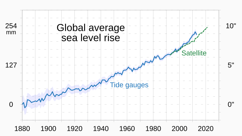
sea level rise
current long-term trend for global sea levels to rise mainly in response to climate change

littoral zone
part of a sea, lake or river that is close to the shore

islet
thumb|Rockall, an islet located west of Ireland and Scotland
thumb|Bàngchuí Island in Dalian, [[Liaoning, China, is a typical rock islet]]
right|thumb|Mōkōlea Rock in Kailua Bay, [[O‘ahu, off North Beach, Marine Corps Base Hawaii]]

shoal
right|thumb|Sandbar between St. Agnes, Isles of Scilly|St Agnes and [[Gugh on the Isles of Scilly, off the coast of Cornwall, England, United Kingdom]]
thumb|A tidal sandbar connecting the islands of Waya Island|Waya and Wayasewa of the [[Yasawa Islands, Fiji]]
thumb|Sandbar between Nosy Iranja Be and Nosy Iranja Kely(Nosy Iranja, [[Madagascar)]]

gulf
REDIRECT Bay#Gulf
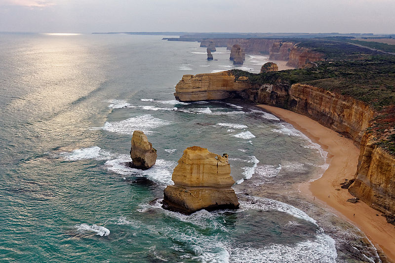
stack
geological landform consisting of a steep and often vertical column or columns of rock
marine transgression
geologic event

salt marsh
type of coastal ecosystem, land outside the dikes that is not flooded with seawater with average high tide

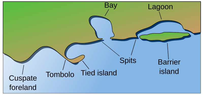
tombolo
thumb|right|300px|Tombolo near Karystos, [[Euboea, Greece]]
thumb|300px|right|Tombolo contrasted with other coastal landforms
A tombolo is a sandy or shingle isthmus. It is a deposition landform by which an island becomes attached to the mainland by a narrow piece of land such as a spit or bar. Once attached, the island is then known as a tied island. The word tombolo is from the Italian '''', meaning 'pillow' or 'cushion', and sometimes translated incorrectly as ayre (an ayre is a shingle beach of any kind).
natural arch
natural rock formation where a rock arch forms
tidal marsh
coastal marsh, marsh subject to tidal change in water
intertidal zone
area between tide marks
continental margin
zone of the ocean floor that separates the thin oceanic crust from thick continental crust
coastal management
defense against flooding and erosion
coastline paradox
counterintuitive observation that the coastline of a landmass does not have a well-defined length
barrier island
coastal landform and a type of dune system
marine regression
geological process of areas of submerged seafloor being exposed above the sea level
coastal geography
study of the region between the sea and the land
tide pool
rocky pool on seashore, separated as pool at low tide, filled with seawater
coastal erosion
loss or displacement of land along a coastline
longshore drift
geological process by which sediments move along a beach shore
blowhole
geological phenomenon, holes in coastal rock formations through which sea water is forced by the tide or waves.

headland
thumb|Land's End, England
A headland, also known as a head, is a coastal landform, a point of land usually high and often with a sheer drop, that extends into a body of water. It is a type of promontory. A headland of considerable size often is called a cape. Headlands are characterised by high, breaking waves, rocky shores, intense erosion, and steep sea cliff.
saltwater intrusion
movement of saline water into freshwater aquifers

Machair
thumb|The machair on Berneray, North Uist|Berneray, [[Outer Hebrides]]
thumb|Machair east of Uig,_Lewis|Uig Bay, Lewis
thumb|The machair towards West beach, Isle of Berneray, Outer Hebrides
wave-cut platform
narrow flat area often found at the base of a sea cliff or along the shoreline of a lake, bay, or sea that was created by erosion
current
flow of water influenced by gravity as the water moves downhill to reduce its potential energy
shingle beach
especially in Europe, a beach composed of pebbles and cobbles
fetch
the length of water over which a given wind has blown
.jpg)
rauk
thumb|upright=1.2|Rauks (wikt:rauk#Gutnish|rauks) at [[Fårö Island, east of mainland Sweden]]
Supralittoral zone
area above the spring high tide line that is regularly splashed, but not submerged by ocean water
Integrated coastal zone management
environmental managment system
Wave shoaling
effect by which surface waves entering shallower water change in wave height
list of peninsulas
Wikimedia list article

beachrock
thumb|Beachrock along Réunion island seashore
thumb|Detail showing fragments of coral and shells
Beachrock is a friable to well-cemented sedimentary rock that consists of a variable mixture of gravel-, sand-, and silt-sized sediment that is cemented with carbonate minerals and has formed along a shoreline. Depending on location, the sediment that is cemented to form beachrock can consist of a variable mixture of shells, coral fragments, rock fragments of different types, and other materials. It can also contain scattered artifacts, pieces of wood, and coconuts. Beachrock typically forms within

Coastal migration
model of early human migration
list of recursive islands and lakes
Wikipedia list of recursive islands and lakes
raised beach
beach or wave-cut platform raised above the shoreline by a relative fall in the sea level
borders of the oceans
limits of the Earth's oceanic waters
avulsion
rapid abandonment of a river channel and formation of a new channel
brackish marsh
marsh with brackish levels of salinity
coastal flood
type of flood
Surf zone
nearshore zone where wave water comes onto the shore
swash
thumb|upright=1.25|Swash
steep coast
area where land meets the sea
freshwater marsh
type of marsh
pocket beach
small beach between two headlands
Gat
inshore channel or strait dividing offshore islands from the mainland, often one that is constantly eroded by currents
Beach evolution
changes to a shoreline by accretion and erosion