Category
page 1Earth sciences

Earth
Earth is the third planet from the Sun and the only astronomical object known to harbor life. This is made possible by Earth being an ocean world, the only one in the Solar System sustaining liquid surface water. Almost all of Earth's water is contained in its global ocean, covering 70.8% of Earth's crust. The remaining 29.2% of Earth's crust is land, most of which is located in the form of continental landmasses within Earth's land hemisphere. Most of Earth's land is at least somewhat humid and covered by vegetation, while large ice sheets at Earth's polar deserts retain more water than Earth

geography
Geography (from Ancient Greek ; combining 'Earth' and 'write', literally 'Earth writing') is the study of the lands, features, inhabitants, and phenomena of Earth. Geography is an all-encompassing discipline that seeks an understanding of Earth and its human and natural complexities—not merely where objects are, but also how they have changed and come to be. While geography is specific to Earth, many concepts can be applied more broadly to other celestial bodies in the field of planetary science. Geography has been called "a bridge between natural science and social science disciplines."

Earth science
fields of science dealing with planet Earth and its nearby planets in space

paleontology
thumb|right|Bust of the paleontologist Georges Cuvier (left) and a cast skeleton of [[Palaeotherium magnum (named by Cuvier in 1804, right), Cuvier Museum of Montbéliard]]

oceanography
thumb|Thermohaline circulation

geophysics
Geophysics () is a physical science concerned with the processes and properties of Earth and its surrounding space environment, studied using quantitative and observational methods. It focuses primarily on Earth’s shape and its gravitational, magnetic, and electromagnetic fields. It also studies internal structure, composition, and dynamics, and their surface expression in tectonics, volcanism, and rock formation. Geophysics also encompasses a broader Earth-system and planetary perspective, including the oceans, atmosphere, cryosphere, ionosphere, magnetosphere, as well as solar–terrestrial in

geodesy
thumb|upright=1.05|A modern instrument for geodetic measurements using satellites

biogeography
thumb|350px|Book frontispiece|Frontispiece to [[Alfred Russel Wallace's book The Geographical Distribution of Animals]]

physical geography
one of the two major subfields of geography

geomorphology
thumb|upright=1.4|Badlands incised into [[shale at the foot of the North Caineville Plateau, Utah, within the pass carved by the Fremont River and known as the Blue Gate. G. K. Gilbert studied the landscapes of this area in great detail, forming the observational foundation for many of his studies on geomorphology.]]
thumb|Surface of Earth, showing higher elevations in red
%20Portrait%20de%20Joseph%20Juste%20Scaliger%20-%20Mus%C3%A9e%20du%20Louvre.jpg)
chronology
thumb|222px|Joseph Scaliger's De emendatione temporum (1583) began the modern science of chronology
.jpg)
geochemistry
Geochemistry is the science that uses the tools and principles of chemistry to explain the mechanisms behind major geological systems such as the Earth's crust and its oceans. The realm of geochemistry extends beyond the Earth, encompassing the entire Solar System, and has made important contributions to the understanding of a number of processes including mantle convection, the formation of planets and the origins of granite and basalt. It is an integrated field of chemistry and geology.
thumb|center|1100px|alt=Time-lapse sequence showing a water droplet forming at the tip of a stalactite.|T

volcanology
thumb|280px|A volcanologist sampling lava using a rock hammer and a bucket of water
thumb|Eruption of Stromboli (Italy), approximately 100 m (300 ft) vertically. Exposure of several seconds. The dashed trajectories are the result of lava pieces with a bright hot side and a cool dark side rotating in mid-air.

weathering
thumb|upright=1.35|A natural arch produced by erosion of differentially weathered rock in Jebel Kharaz ([[Jordan)]]
environmental science
interdisciplinary field that studies human interaction with the environment

speleology
thumb|Grotte des Faux-Monnayeurs, Mouthiers-Haute-Pierre (France)
thumb|Beam of sun inside the cavity of Rocca ill'Abissu, Fondachelli-Fantina|Fondachelli Fantina, [[Sicily]]
thumb|Pirunkirkko (literally "devil's church") of Paistjärvi, a peak cave in [[Heinola, Päijät-Häme, Finland]]
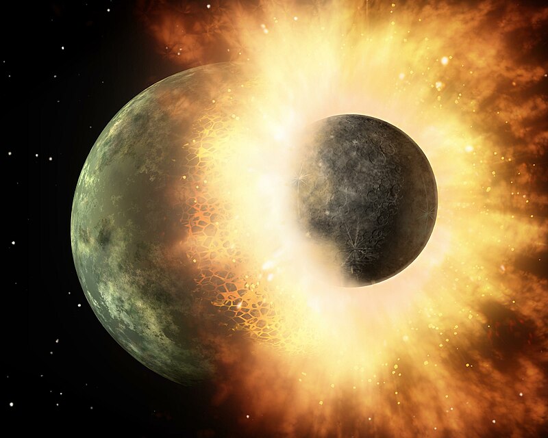
Theia
planet that is hypothesized to have impacted Earth and created the Moon

palynology
thumbnail|300px| Pine [[pollen under the microscope]]
thumb|300px| A late Silurian [[sporangium bearing trilete spores. Such spores provide the earliest evidence of life on land. Green: A spore tetrad. Blue: A spore bearing a trilete mark – the Y-shaped scar. The spores are about 30–35 μm across.]]

sedimentology
Sedimentology encompasses the study of modern sediments such as sand, silt, and clay, and the processes that result in their formation (erosion and weathering), transport, deposition and diagenesis. Sedimentologists apply their understanding of modern processes to interpret geologic history through observations of sedimentary rocks and sedimentary structures. Sedimentology is a subdiscipline of geology.

sedimentation
Sedimentation is the deposition of sediments. It takes place when particles in suspension settle out of the fluid in which they are entrained and come to rest against a barrier. This is due to their motion through the fluid in response to the forces acting on them: these forces can be due to gravity, centrifugal acceleration, or electromagnetism. Settling is the falling of suspended particles through the liquid, whereas sedimentation is the final result of the settling process.

geopark
A geopark is a protected area with internationally significant geology within which sustainable development is sought and which includes tourism, conservation, education and research concerning not just geology but other relevant sciences. It also supports the communities that live in its boundaries.
giant impact hypothesis
theory that the Moon formed out of the debris left over from a collision between Earth and an astronomical body the size of Mars, approximately 4.5 billion years ago

Earth's energy budget
accounting of the energy flows which determine Earth's surface temperature and drive its climate

geoinformatics
thumb|Leaflet (software)|Leaflet library is often used in geoinformatics for the development of web [[map applications]]
Geoinformatics is a scientific field primarily within the domains of Computer Science and technical geography. It focuses on the programming of applications, spatial data structures, and the analysis of objects and space-time phenomena related to the surface and underneath of Earth and other celestial bodies. The field develops software and web services to model and analyse spatial data, serving the needs of geosciences and related scientific and engineering disciplines. The
history of life
processes by which organisms evolved on Earth
Portal:Earth sciences
Wikimedia portal
planetary boundary
limits not to be exceeded if humanity wants to survive in a safe ecosystem
reference ellipsoid
ellipsoid that approximates the figure of the Earth
International Polar Year
efforts with intensive research foci on the polar regions
Earth analog
another planet with environmental conditions similar to those found on the planet Earth
Global Boundary Stratotype Section and Point
boundary of a stage on the geologic time scale
climate system
system of interaction and processes that regulate the Earth's climate
geomechanics
Geomechanics (from the Greek γεός, i.e. prefix geo- meaning "earth"; and "mechanics") is the study of the mechanical state of the Earth's crust and the processes occurring in it under the influence of natural physical factors. It involves the study of the mechanics of soil and rock.

biospeleology
thumb|right|A 3D cross-section of the Lukina jama–Trojama [[cave system in the Velebit mountains of Croatia. The collection sites (1) of the shells and the single living specimen (2) of the cave-dwelling snail Zospeum tholussum are indicated.]]
thumb|The spider Trogloraptor marchingtoni from a cave in [[Oregon.]]

aufeis
thumb|upright|Laminations of ice in a sheet of aufeis
Aufeis ( ) (German for "ice on top") is a sheet-like mass of layered ice that forms from successive flows of ground or river water during freezing temperatures. This form of ice is also called overflow, icings, or the Russian term, naled (). The term "Aufeis" was first used in 1859 by Alexander von Middendorff following his observations of the phenomenon in northern Siberia.
Clarke number
relative abundance of elements in Earth's crust
ocean heat content
thermal energy stored in ocean water
soil solarization
natural occurence
anthroposphere
The anthroposphere refers to that part of the Earth system that is inhabited and influenced by humans. The term has been included as one of the Earth's spheres, building on a concept coined by Austrian geologist Eduard Suess.
traverse
surveying method
physiographic regions of the world
classification system for Earth's landforms based on the work on N. M. Fenneman
colmation
thumb|upright=1.25|Siltation of a waterway
Siltation is water pollution caused by particulate terrestrial clastic material, with a particle size dominated by silt or clay. It refers both to the increased concentration of suspended sediments and to the increased accumulation (temporary or permanent) of fine sediments on bottoms where they are undesirable. Siltation is most often caused by soil erosion or sediment spill.
Medea hypothesis
hypothesis that multicellular life, understood as a superorganism, is suicidal, and that microbial-triggered mass extinctions are attempts to return the Earth to a microbial-dominated state
settling
thumb|Settling pond for iron particles at water works
rings of Earth
hypothetical former ring system around Earth first formally proposed in September of 2024
mobile mapping
process of collecting geospatial data from a mobile vehicle
Magnetotellurics
thumb|Magnetotelluric station
fluvioglacial landform
landform shaped by erosion and deposition from glacial meltwater
global surface temperature
average temperature of the Earth's surface
Global Standard Stratigraphic Age
void ratio
dimensionless quantity related to porosity
Solid Earth
the planet's solid surface and its interior
GNS Science
New Zealand research institute
International Year of Planet Earth
international year designated by the United Nations

wetted perimeter
perimeter of a cross sectional area that is wet
Cascades Volcano Observatory
Volcano observatory
Bedford Level experiment
series of observations carried out along a six-mile length of the Old Bedford River in an attempt to determine the shape of the Earth
list of Earth observation satellites
Wikimedia list article
GEOBASE
GEOBASE is a database, multidisciplinary in scope, which indexes bibliographic information and abstracts for the Geographical, Earth, and Ecological sciences, published by Engineering Information, a subsidiary of Elsevier. The broad subject coverage includes earth sciences, ecology, geomechanics, human geography, physical geography, social geography and oceanography. Development studies are also included in this database.
outline of earth science
hierarchical outline list of articles related to Earth sciences