Category
page 1Geodesy

geographic coordinate system
system to specify locations on Earth

equator
thumb|150px|right|The equator (yellow line) at the December solstice. The direction of the Sun is to the left.
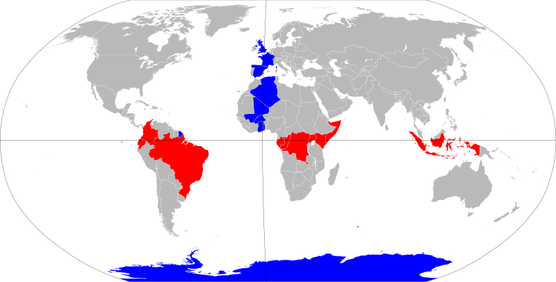
thumb|upright=1.35|Countries and territories that are intersected by the equator (red) or the IERS Reference Meridian|Prime Meridian (blue), which intersect at "[[Null Island".]]
The equator is the circle of latitude that divides Earth into the Northern and Southern Hemispheres. It is an imaginary line located at 0 degrees latitude, about in circumference, halfway between the North and South Poles. The term can also be used for any other celestial body that is roughly spherical.

map
thumb|Map of the world published in Amsterdam in the 17th century

latitude
thumb|Earth model with circles of latitude in black and indications of the North Pole, [[Equator, and the northern and southern hemispheres.]]
thumb|upright=0.9|right|Earth's Graticule (cartography)|graticule. The vertical lines from pole to pole are lines of constant [[longitude, or meridians. The circles parallel to the equator are lines of constant latitude, or parallels. The graticule shows the latitude and longitude of points on the surface. In this example meridians are spaced at 6° intervals and parallels at 4° intervals.]]

longitude
thumb|Earth with blue longitude lines and corresponding degrees.
thumb|upright=0.9|A Geographic coordinate system|graticule on the [[Earth as a sphere or an ellipsoid. The lines from pole to pole are lines of constant longitude, or meridians. The circles parallel to the Equator are circles of constant latitude, or parallels. The graticule shows the latitude and longitude of points on the surface. In this example, meridians are spaced at 6° intervals and parallels at 4° intervals.]]

tide
300px|thumb|upright=1|Simplified schematic of only the lunar portion of Earth's tides, showing (exaggerated) high tides at the sublunar point and its antipodal point|antipode for the hypothetical case of an ocean of constant depth without land, and on the assumption that Earth is not rotating; otherwise there is a lag angle. Solar tides not shown.|alt=
right|thumb|Earth's rotation drags the position of the tidal bulge ahead of the position directly under the Moon showing the lag angle.
thumb|In Maine (U.S.), low tide occurs roughly at moonrise and high tide with a high Moon, corresponding to t

sea level
average level for the surface of one or more of Earth's oceans

cartography
thumb|upright=1.35|A medieval depiction of the Ecumene (1482, Johannes Schnitzer, engraver), constructed after the coordinates in Ptolemy's Geography and using his second map projection. The translation into Latin and dissemination of Geography in Europe, in the beginning of the 15th century, marked the rebirth of scientific cartography, after more than a millennium of stagnation.

geophysics
Geophysics () is a physical science concerned with the processes and properties of Earth and its surrounding space environment, studied using quantitative and observational methods. It focuses primarily on Earth’s shape and its gravitational, magnetic, and electromagnetic fields. It also studies internal structure, composition, and dynamics, and their surface expression in tectonics, volcanism, and rock formation. Geophysics also encompasses a broader Earth-system and planetary perspective, including the oceans, atmosphere, cryosphere, ionosphere, magnetosphere, as well as solar–terrestrial in

geodesy
thumb|upright=1.05|A modern instrument for geodetic measurements using satellites

estuary
thumb|Río de la Plata estuary
thumb|Mattole River estuary

navigation
thumb|A navigation system on an oil tanker
Navigation is a field of study that focuses on the process of monitoring and controlling the movement of a craft or vehicle from one place to another. The field of navigation includes four general categories: land navigation, marine navigation, aeronautic navigation, and space navigation. It is also the term of art used for the specialized knowledge used by navigators to perform navigation tasks. All navigational techniques involve locating the navigator's position compared to known locations or patterns. Navigation, in a broader sense, can refer to a

azimuth
right|thumb|The azimuth is the angle formed between a reference direction (in this example north) and a sightline|line from the observer to a point of interest projected on the same plane as the reference direction orthogonal to the [[zenith.]]

geographical pole
point of intersection of a celestial body’s surface and its rotational axis

summit
thumb|upright=1.05|A climber taking the final few steps to the summit of Imja Tse (Island Peak) in [[Nepal, 2004]]
thumb|View from the summit of Switzerland's highest peak, [[Monte Rosa]]

geoid
thumb|upright=1.5|Map of the undulation of the geoid in meters (based on the EGM96 gravity model and the [[WGS84 reference ellipsoid).]]
height above mean sea level
elevation of a location in reference to a historic mean sea level taken as a vertical datum

gravitational field
direction and intensity of gravity in every point of space
remote sensing
acquisition of information about an object or phenomenon without making physical contact with the object, especially the Earth

theodolite
thumb|A direct-readout theodolite, manufactured in the Soviet Union in 1958 and used for topographic surveying

global navigation satellite system
system of satellites that provide autonomous geo-spatial positioning with global coverage

spirit level
instrument with a sealed tube of liquid, designed to indicate whether a surface is horizontal (level) or vertical (plumb)

map projection
representation of the surface of a sphere or ellipsoid onto a plane map
prime meridian
line of longitude, at which longitude is defined to be 0°

photogrammetry
thumb|upright=1.3|Low altitude aerial photograph for use in photogrammetry. Location: Three Arch Bay, [[Laguna Beach, California.]]
Photogrammetry is the science and technology of obtaining reliable information about physical objects and the environment through the process of recording, measuring and interpreting photographic images and patterns of electromagnetic radiant imagery and other phenomena.
thumb|Photogrammetry of the headquarters of Fazenda do Pinhal, São Carlos-SP, Brazil
While the invention of the method is attributed to Aimé Laussedat, the term "photogrammetry" was coined by the
gravity of Earth
acceleration that the Earth imparts to objects on or near its surface

orbit of Earth
gravitationally curved trajectory Earth travels around the Sun
total station
combined electronic theodolite and electronic distance meter; used in surveying and building construction
rhumb line
arc crossing all meridians of longitude at the same angle

selenography
thumb|right|345px|alt=Topography of the Moon measured from the Lunar Orbiter Laser Altimeter on the mission Lunar Reconnaissance Orbiter, referenced to a sphere of radius 1737.4 km|Topography of the Moon.
thumb|Moon 360 animation in 4K resolution|4K

geodynamics
Geodynamics is a subfield of geophysics dealing with dynamics of the Earth. It applies physics, chemistry and mathematics to the understanding of how mantle convection leads to plate tectonics and geologic phenomena such as seafloor spreading, mountain building, volcanoes, earthquakes, or faulting. It also attempts to probe the internal activity by measuring magnetic fields, gravity, and seismic waves, as well as the mineralogy of rocks and their isotopic composition. Methods of geodynamics are also applied to exploration of other planets.
inertial navigation system
continuously computed dead reckoning

flatness
thumb|right|200px |A circle of radius compressed to an ellipse.
thumb|right|200px |A sphere of radius compressed to an oblate ellipsoid of revolution.
Universal Transverse Mercator
cartographic coordinate system

gravimetry
thumb|upright|An Autograv CG-5 gravimeter being operated

elevation
thumb|upright=1.4|Vertical distance comparison

geomatics
thumb|A surveyor's shed showing equipment used for geomatics
Cavendish experiment
gravity experiment
reference ellipsoid
ellipsoid that approximates the figure of the Earth
gravity anomaly
difference between the observed acceleration of a planet's gravity and a value predicted from a model

geopositioning
thumb|upright=1.5|Principles of geolocation using GPS
figure of the Earth
mathematical descriptions of Earth's complex shape
spherical Earth
assertion that the Earth is (at least approximately) spherical
very-long-baseline interferometry
type of astronomical interferometry used in radio astronomy
Paris meridian
meridian line running through the Paris Observatory in Paris, France
digital elevation model
3D model of land elevation and features; for specific DSM or DTM use specific wikidata IDs
tidal acceleration
cause of tidal locking
virtual globe
3D software model or representation of the Earth or another world
World Geodetic System
geodetic reference system
transit instrument
astronomical instrument
gravitation of the Moon
Schiehallion experiment
experiment to determine the mean density of the Earth
haversine formula
formula for the great-circle distance between two points on a sphere
47th meridian west
line of longitude west of the Greenwich Meridian
GRS 80
reference ellipsoid
Military Grid Reference System
global coordinate reference system

Hermannskogel
The Hermannskogel () is a hill in Döbling, the 19th district of Vienna. At 542 metres above sea level, it is the highest natural point of Vienna. It lies on the border to Lower Austria.
Ordnance Survey National Grid
system of geographic grid references used in Great Britain
equatorial bulge
outward bulge around a planet's equator due to its rotation

ED50
ED50 ("European Datum 1950", EPSG:4230) is a geodetic datum which was defined after World War II for the international connection of geodetic networks.