Category
page 1Geography terminology

mountain
thumb|upright=1.2|Mount Everest, Earth's highest mountain

population density
measurement of population per unit area or unit volume

plain
thumb|right|The Kakanui Range dominates the eastern horizon of the [[Maniototo Plain of New Zealand]]
In geography, a plain, commonly known as flatland, is a flat expanse of land that generally has few rapid or steep changes in elevation. Natural vegetation in plains can include prairies/grasslands, forests, savanah, tundra, and desert biomes, among others. Plains occur as lowlands along valleys or at the base of mountains, as coastal plains, and as plateaus or uplands. Plains are one of the major landforms on earth, being present on all continents and covering more than one-third of the world

region
In geography, regions, otherwise referred to as areas, zones, lands or territories, are portions of the Earth's surface that are broadly divided by physical characteristics (physical geography), human impact characteristics (human geography), and/or the interaction of humanity and the environment (environmental geography). Geographic regions and sub-regions are mostly described by their imprecisely defined, and sometimes transitory boundaries, except in human geography, where jurisdiction areas such as national borders are defined in law. More confined or well bounded portions are called locat

land
thumb|upright=1.3|Land between bodies of water at Point Reyes National Seashore, California|alt=A grassy isthmus running between two bodies of water
height above mean sea level
elevation of a location in reference to a historic mean sea level taken as a vertical datum

Orient
thumb|Ancient Orient of the Roman Empire and its ecclesiastical order after the [[Council of Chalcedon, 451|300x300px]]
The Orient is a term referring to the East in relation to Europe, traditionally comprising anything belonging to the Eastern world. It is the antonym of the term Occident, which refers to the Western world.

mesa
thumb|Aerial view of mesas in Monument Valley, on the [[Colorado Plateau]]
thumb|right|Har Qatum, a mesa located on the southern edge of Makhtesh Ramon, Israel
thumb|Ingleborough in North Yorkshire, England
thumb|Mount Garfield (Mesa County, Colorado)|Mount Garfield, a mesa in Colorado
A mesa is an isolated, flat-topped elevation, ridge, or hill, bounded from all sides by steep escarpments and standing distinctly above a surrounding plain. Mesas consist of flat-lying soft sedimentary rocks, such as shales, capped by a resistant layer of harder rock, like sandstone or limestone, forming a capro

landmass
thumb|Afro-Eurasia, the largest landmass on Earth

monolith
thumb|Niapiskau island, limestone monoliths, Gulf of St. Lawrence, [[Mingan Archipelago National Park Reserve, Canada]]
thumb|Uluru, [[Northern Territory, Australia, is often referred to as the biggest monolith. While the surrounding rocks were eroded, the rock survived as sandstone strata making up the surviving Uluru 'monolith'.]]
thumb|Monolithos, Greece|Monolithos fortress on [[Rhodes, Greece]]
thumb|Landsat 7 image [[Brandberg Mountain, Namibia]]
thumb|Pedra da Gávea|Gavea Rock, a monolith next to the sea, near [[Rio de Janeiro, Brazil]]
A monolith is a geological feature consisting of a

lowland
REDIRECT Upland and lowland#Lowland

alluvial fan
fan- or cone-shaped deposit of sediment crossed and built up by streams
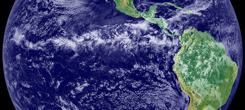
Intertropical Convergence Zone
Meteorological phenomenon

alluvial plain
region on which rivers have deposited sediment

butte
thumb|West and East Mitten Buttes|The Mittens and [[Merrick Butte in Monument Valley, Utah–Arizona]]

landmark
thumb|upright=1.3|An 18th-century painting of a ship with Table Mountain in the background, used by navigators as the landmark to sail around southern tip of Africa.
A landmark is a recognizable natural or artificial feature used for navigation, a feature that stands out from its near environment and is often visible from long distances.

polynya
thumb|Coastal polynyas are produced in the Antarctic by katabatic winds
thumb|Katabatic wind spilling off an ice shelf|upright
thumb|A frosty Arctic condensation plume marks this polynya near the west shore of Hudson Bay. This one (and others nearby) are likely kept open by tidal currents. Mile-high west-facing aerial view.
hinterland
Hinterland is the area under the influence of a particular human settlement.
genius loci
atmosphere of character of a location; source of inspiration
natural landscape
original landscape formed by nature
endorheic lake
lake with no outflow to other external bodies of water, such as rivers or oceans
tunnel valley
U-shaped valley originally cut by water under the glacial ice near the margin of continental ice sheets
geographical feature
components of planets that can be geographically located
%20-%20Geographicus%20-%20RomanEmpireWest-anville-1763.jpg)
Occident
thumb|Ancient Occident of the Roman Empire
The Occident is a term for the West, traditionally comprising anything that belongs to the Western world. It is the antonym of the term Orient, referring to the Eastern world. In English, it has largely fallen into disuse. The term occidental is often used to describe objects from the Occident but can be considered an outdated term by some. The term originated with geographical divisions mirroring the cultural divide between the Greek East and the Latin West, and the political divide between the Western and Eastern Roman Empires.
table
A tableland is an area containing elevated landforms characterized by a distinct, flat, nearly level, or gently undulating surface. They often exhibit steep, cliff-like edges, known as escarpments, that separate them from surrounding lowlands. Depending on either their size, other physical characteristics, or geographic location, the landforms comprising a tableland are individually referred to by a number of names including butte, mesa, plateau, potrero, tepui, or tuya. A homologous landform under the sea is called either a tablemount or guyot.
Sector model
model of urban land use proposed in 1939
.jpg)
anthropization
320x320px|thumb|right|An example of advanced anthropization: the cultivation of rice in terraces in [[Vietnam]]

hermit kingdom
term applied to an isolationist country, especially Korea
geosophy
Geosophy is a concept introduced to geography by J.K. Wright in 1947. The word is a compound of ‘geo’ (Greek for earth) and ‘sophia’ (Greek for wisdom). Wright defined it thus:
Macedonia
terminology used for entities related to the Southeast European historical region
dell
small wooded valley, slope landform
backcountry
thumb|The Pocosin cabin along the Appalachian Trail in [[Shenandoah National Park.]]
Precordillera
thumb|Precordillera, Province of Mendoza, Argentina
Precordillera is a Spanish geographical term for hills and mountains lying before a greater range, similar to foothills. The term is derived from cordillera (mountain range)—literally "pre-mountain range"—and applied usually to the Andes.
spatial scale
extent or size of a length, distance, or area being studied or described
Massenerhebung effect
physiographic province
mid-level region in the Fenneman model of physiographic regionalization
sense of place
character and atmosphere of a place, the emotions evoked, special qualities, situation, and so on
getting lost
losing spatial reference
término municipal
territory of a municipality of Spain or Portugal, on which the jurisdiction of a town hall extends
boundary
legal limit of an immovable real estate property
Residential segregation
the physical separation of two or more groups into different neighborhoods
intermontane
Intermontane is a physiographic adjective formed from the prefix "inter-" (signifying among, between, amid, during, within, mutual, reciprocal) and the adjective "montane" (inhabiting, or growing in mountainous regions, especially cool, moist upland slopes below the timberline).
pan-region
thumb|290x290px|Pan region map
A pan-region is a geographic region or state's sphere of economic, political and cultural influence extending beyond that state's borders. For example, the pan-region of the United States of America (US) regions both bordering the US and its close neighbours including, Canada, Mexico, and many other South America states.
Alfoz
anatopism
An anatopism (from the Ancient Greek , "against," and , "place") is something that is out of its proper place.
Upstate
The term upstate may refer to the northerly portions of several U.S. states. On the east coast, upstate generally refers to places away from the Atlantic Ocean. It also can refer to parts of states that have a higher elevation, away from sea level. These regions tend to be rural; exceptions include Delaware and Illinois.
single entity of population
Spanish statistical unit of human settlements