Category
page 1Hydrography

hydrography
thumb|right|upright=1.3|Table of geography, hydrography, and navigation, from a 1728 Cyclopaedia, or an Universal Dictionary of Arts and Sciences|Cyclopaedia
Hydrography is the branch of applied sciences which deals with the measurement and description of the physical features of oceans, seas, coastal areas, lakes and rivers, as well as with the prediction of their change over time, for the primary purpose of safety of navigation and in support of all other marine activities, including economic development, security and defense, scientific research, and environmental protection.

limnology
thumb|upright=1.3|Lake Hāwea, New Zealand
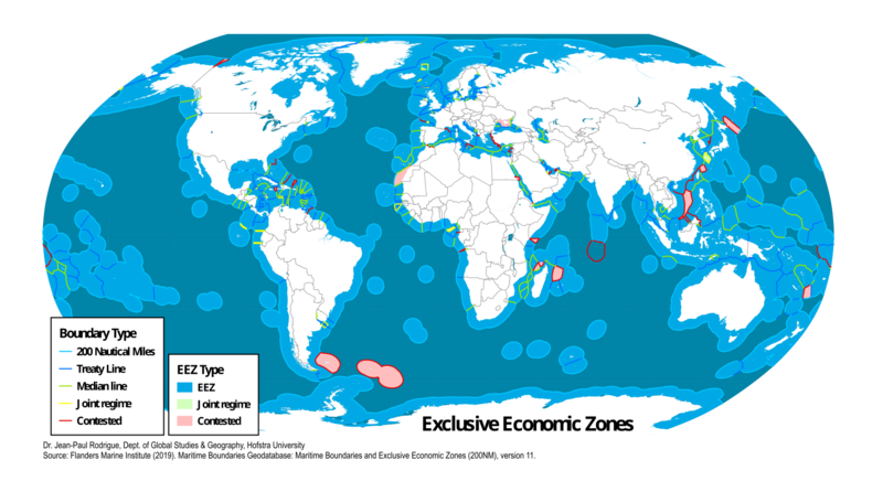
exclusive economic zone
UN maritime zone

territorial sea
coastal waters that are part of a nation-state's sovereign territory
internal water
waters on the landward side of the baseline of a nation's territorial waters, except in archipelagic states
research vessel
ship or boat designed, modified, or equipped to carry out research at sea
baseline
the line from which the seaward limits of a state's territorial sea and certain other maritime zones of jurisdiction are measured; normally, a sea baseline follows the low-water line of a coastal state
bathymetric chart
map visually representing the submerged terrain
notice to mariners
periodical literature for seamen
depth sounding
method of measuring the depth of a body of water

Conductivity, temperature, depth
oceanography instrument used to measure the conductivity, temperature, and pressure of seawater

Baiheliang
thumb|Poster displayed at the Baiheliang Underwater Museum showing the configuration of the White Crane Ridge before the construction of the [[Three Gorges Dam]]
thumb|A Qing dynasty carved fish, previously placed on the White Crane Ridge, now displayed in the museum.
hydrographic survey
analysis of the topography of bodies of water, providing data for environmental, tidal calculations, maritime navigation, etc.
Sailing Directions
details of routes for coastal navigation
General Bathymetric Chart of the Oceans
offers a publicly available bathymetric chart of the world's oceans
Noosfera
supply and research ship operated by the National Antarctic Scientific Center of Ukraine
rosette sampler
device used to assess water quality
Integrated multi-trophic aquaculture
type of aquaculture
admiralty chart
brand of nautical chart
multibeam echosounder
type of sonar that is used to map the seabed
Eastern Continental Divide
hydrological divide in eastern North America
list of lights
publication describing lighthouses and other aids to maritime navigation
Confederación Hidrográfica del Ebro
Spanish organization responsible for the management, regulation and maintenance of the waters and irrigation of the Ebro river basin