Category
page 1Luster Municipality
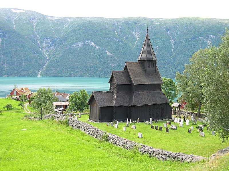
Urnes Stave Church
church building in Luster, Vestland, Norway

Jostedal Glacier
largest glacier in continental Europe
Luster Municipality
municipality in Vestland, Norway
Jotunheimen National Park
national park
Jostedalsbreen National Park
national park of Norway
Store Skagastølstind
mountain
Jervvasstind
Gjertvasstind or Jervvasstind is Norway's ninth-highest mountain. The mountain lies in the Hurrungane mountains in the eastern part of Luster Municipality in Vestland county, Norway. It lies on the eastern end of a mountain ridge including the mountains (west to east) Store Skagastølstind-Vetle Skagastølstind-Sentraltind-Store Styggedalstind-Gjertvvasstind. The village of Skjolden is located to the west.
Store Styggedalstinden
Styggedalstindane is the fourth-highest summit in Norway. It is located within the Hurrungane mountains, which are part of the Jotunheimen mountain range. The mountain is located in the eastern part of Luster Municipality in Vestland county, Norway. This mountain sits directly between the mountains Sentraltind and Gjertvasstind.
Sentraltind
Sentraltind is a mountain in the Hurrungane mountains in the Jotunheimen mountain range. The tall mountain is located in the eastern part of Luster Municipality in Vestland county, Norway. It is the 10th highest summit in Norway. Sentraltind lies on a ridge between Storen-Vetle Skagastølstindane and Styggedalstindane-Gjertvasstind. The mountain is east of the village of Skjolden.

Skjolden
Skjolden is a village in Luster Municipality in Vestland county, Norway. It is located at the end of the Lustrafjorden, a branch of the Sognefjorden. Skjolden is located at the innermost point of the Sognefjorden (Norway's longest fjord). The length of the Sognefjorden is over and it is measured from Skjolden to the island of Ytre Sula where the fjord meets the ocean. The valleys of Mørkridsdal and Fortunsdal meet at Skjolden, just west of the Hurrungane mountains.
Lodalskåpa
Lodalskåpa is the highest nunatak on the Norwegian glacier Jostedalsbreen. It is located on the border between Stryn Municipality and Luster Municipality in Vestland county, Norway, within Jostedalsbreen National Park.

Hurrungane
Hurrungane is a mountain range in Luster Municipality and Årdal Municipality in Vestland county, Norway. The area is southwest in the larger mountain range Jotunheimen and is also part of Jotunheimen National Park.
Fannaråki
Fannaråki is a mountain in Luster Municipality in Vestland county, Norway. The tall mountain is located in the Jotunheimen National Park, just south of the lake Prestesteinsvatnet and the Sognefjellsvegen road. This mountain is located about north of the Skagastølstindane mountains (Storen, Vetle Skagastølstindane, Midtre Skagastølstindane, Sentraltind, Styggedalstindane, and Gjertvasstind).
Gaupne
Gaupne is the administrative center of Luster Municipality in Vestland county, Norway. The village is located along the Gaupnefjorden, an arm of the Lustrafjorden, about north of the village of Hafslo. The village of Veitastrond is located across the mountains to the northwest. The Sognefjellsvegen road passes through here on its way to the village of Skjolden and beyond.
Vetle Skagastølstind
mountain

Hafslo
settlement in Luster Municipality, Norway
Tverrådalskyrkja
Tverrådalskyrkja is a mountain on the border of Skjåk Municipality in Innlandet county and Luster Municipality in Vestland county, Norway. The tall mountain is located in the Breheimen mountains and inside the Breheimen National Park, just north of the large Harbardsbreen glacier. It is north of the village of Skjolden in Luster Municipality and southwest of Bismo in Skjåk Municipality. The mountain is surrounded by several other notable mountains including Tundradalskyrkja to the east, Holåtindan to the southeast, Røykjeskarhøi to the west, and Syrtbyttnosi to the northwest.
Nigardsbreen
Nigardsbreen () is a glacier arm of the large Jostedalsbreen glacier. Nigardsbreen lies about north of the village of Gaupne in the Jostedalen valley in Luster Municipality in Vestland county, Norway. It is located just west of the Jostedøla river.
Breheimen
Breheimen is a mountain range in the Innlandet and Vestland counties in Norway. The area lies west of the Jotunheimen mountain range. The mountain range lies to the northwest of the Sognefjellsvegen road, north of the Sognefjorden, south of the Nordfjorden and Norwegian National Road 15, and east of Norwegian National Road 5 and European route E39. The mountain range includes Jostedalsbreen National Park and Breheimen National Park.
Store Austanbottstind
mountain summit in Norway
Prestesteinsvatnet
Prestesteinsvatnet () is a lake in Luster Municipality in Vestland county, Norway, with a small part of the lake crossing over into the neighboring Lom Municipality in Innlandet county. The lake sits at an elevation of above sea level. It lies along the south side of the Sognefjellsvegen road, just to the north of the mountain Fannaråki and the Fannaråkbreen glacier. The lake sits just outside the borders of Jotunheimen National Park. The village of Skjolden lies about to the southwest of the lake.

Ornes
village in Luster, Norway
Urdanostindene
Uranostinden is a mountain in Norway. The peak marks the tri-point border between Luster Municipality, Årdal Municipality (both in Vestland county), and Vang Municipality (in Innlandet county). The tall mountain is located in the Jotunheimen mountains and inside the Jotunheimen National Park. The mountain sits about northwest of the village of Vang i Valdres and about northeast of the village of Øvre Årdal. The mountain is surrounded by several other notable mountains including Mjølkedalstinden to the northeast, Langeskavltinden and Storegut to the east, Langeskavlen to the southeast, and Falk
Fortun Church
church building in Luster, Vestland, Norway
Midtre Skagastølstind
mountain
Brenibba
Brenibba is a nunatak protruding from the north end of the Jostedalsbreen glacier in the Breheimen mountain range. It is located in Luster Municipality in Vestland county, Norway. Brenibba is located south of Lodalskåpa and northeast of Høgste Breakulen. The mountain lies within Jostedalsbreen National Park. The lakes Austdalsvatnet and Styggevatnet are located west of Brenibba.
Stetinden
mountain
Høgste Breakulen
mountain in Norway

Solvorn
Solvorn is a village in Luster Municipality in Vestland county, Norway. The village is located on the western shore of the Lustrafjorden, the innermost part of the Sognefjorden. The village sits directly across the fjord from the village of Ornes, where the famous 12th-century Urnes Stave Church is located. The village of Hafslo lies about to the northwest.
Mjølkedalstinden
Mjølkedalstinden is a mountain in Luster Municipality in Vestland county, Norway. The tall mountain lies south of the Rauddalen valley, about east of the village of Fortun. It is easily climbed from the ridge from the north-west.
Harbardsbreen
Harbardsbreen is the 10th largest glacier in mainland Norway. It is located on the south side of the Tverrådalskyrkja mountain in the Breheimen mountain range in Luster Municipality in Vestland county, Norway.
Tundradalskyrkja
Tundradalskyrkja is a mountain on the border of Skjåk Municipality in Innlandet county and Luster Municipality in Vestland county, Norway. The tall mountain is located in the Breheimen mountains and inside the Breheimen National Park, about south of the village of Grotli and about northeast of the Jostedalen valley. The mountain is surrounded by several other notable mountains including Gjelhøi to the east, Holåtindan to the southeast, Tverrådalskyrkja to the west, and Syrtbyttnosi to the northwest.
Storegut
Storegut is a mountain on the border of Vang Municipality in Innlandet county and Luster Municipality in Vestland county, Norway. The tall mountain is located in the Jotunheimen mountains and inside the Jotunheimen National Park. The mountain sits about north of the village of Tyinkrysset. The mountain is surrounded by several other notable mountains including Uranostinden and Langeskavltinden to the west, Langeskavlen to the southwest, Høgbrøthøgde to the east, and Snøholstinden and Store Rauddalseggje to the northeast.
Dale Church
church building in Luster, Vestland, Norway
Styggevatnet
Styggevatnet is a glacial lake from the glacier Jostedalsbreen in Luster Municipality in Vestland county, Norway. The lake is regulated by a dam and it empties into the river Jostedøla. The lake originally was located immediately to the southeast of the lake Austdalsvatnet, but after the construction of the dam, the two lakes have grown together as the water level rose. The lake is about to the east of Lodalskåpa and Brenibba in Jostedalsbreen National Park.
Austerdalsbreen
Austerdalsbreen is a glacier in Luster Municipality in Vestland, Norway. It is a side branch of the Jostedalsbreen glacier, and is included in the Jostedalsbreen National Park. The glacier is fed by the three steep glaciers Odinbreen, Torbreen and Lokebreen. The lower, flat part of the glacier displays a characteristic fishbone or lobster tail pattern.
Jostedalen
Jostedalen is a river valley in Luster Municipality in Vestland county, Norway. The long valley runs from the Lustrafjorden at the village of Gaupne, to the north along the river Jostedøla and along the eastern side of the Jostedal Glacier. The valley is deep, but the valley floor lies over long stretches of flat river plains interrupted by steep steps. In the north, the landscape gets pretty wild. The Jostedalsbreen National Park surrounds the valley, which brings a lot of tourism to the area. The Nigardsbreen glacier is also accessible from the valley.

Veitastrond
Veitastrond is a small village in the western part of Luster Municipality in Vestland county, Norway. It is located near the Jostedalsbreen glacier, and Jostedalsbreen National Park surrounds the village on three sides. Veitastrond is located at the northern end of an isolated valley. There is only one road access to Veitastrond, a long road heading northwest from the village of Hafslo, the nearest urban center. Veitastrond sits about from the village of Gaupne, the municipal center.
Jostedøla
Jostedøla (or unofficially: Jostedalselva) is a river which runs through the Jostedalen valley in Luster Municipality in Vestland county, Norway. The Jostedøla river begins near the Fåbergstølen mountain farm where the runoff from the great Jostedalsbreen glacier and the lakes Austdalsvatnet and Styggevatnet comes together in the Jostedalen valley. It then flows south for about , through the Jostedalen valley, and finally empties into the Gaupnefjorden (a small arm off of the Sognefjorden) at the village of Gaupne. The river is the main collector of water for an watershed area. The river is gr
Utladalen
Utladalen is a valley in Årdal Municipality in Vestland county, Norway. It stretches north from the village of Øvre Årdal into the neighboring Luster Municipality. The Avdalen and Fardalen valleys branch off of the main Utladalen valley.
Gravdalstinden
Gravdalstinden is a mountain on the border of Luster Municipality in Vestland county and Lom Municipality in Innlandet county, Norway. The tall mountain is located in the Jotunheimen mountains within Jotunheimen National Park. The mountain sits about southwest of the village of Fossbergom and about northeast of the village of Øvre Årdal. The mountain is surrounded by several other notable mountains including Fannaråki to the west; Smørstabbtindene, Storebjørn, Veslebjørn, Sokse, and Kniven to the north; Stetinden and Stehøe to the northeast; and Høgvagltindane and Kyrkja to the east.
Fet Church
church building in Luster, Vestland, Norway
Old Gaupne Church
cultural heritage church in Gaupne, Luster municipality, Norway
Hafslo Church
church building in Luster, Vestland, Norway
Austdalsvatnet
Austdalsvatnet is a lake in the northwestern part of Luster Municipality in Vestland county, Norway. It is located in the Breheimen mountain range at the end of the Austdalsbreen glacier, just north of the lake Styggevatnet. The lake originally was located immediately to the northwest of the lake Styggevatnet, but after the construction of the dam on the south end of Styggevatnet, the two lakes have grown together as the water level rose. It is about east of Lodalskåpa and Brenibba, in the Jostedalsbreen glacier. The water is regulated by a dam on lake Styggevatnet and it empties into the Jost
Stehøi
Stehøe is a mountain on the border of Luster Municipality in Vestland county and Lom Municipality in Innlandet county, Norway. The tall mountain is located in the Jotunheimen mountains within Jotunheimen National Park. The mountain sits about southwest of the village of Fossbergom and about northeast of the village of Øvre Årdal. The mountain is surrounded by several other notable mountains including Kyrkja and Kyrkjeoksle to the east, Høgvagltindane to the southeast, Surtningstinden and Gravdalstinden to the southwest, Smørstabbtindene and Stetinden to the northwest, and Tverrbottindene to th
Rivenoskulen
Rivenoskulen is a mountain on the border of Skjåk Municipality in Innlandet county and Luster Municipality in Vestland county, Norway. The tall mountain is located in the Breheimen mountains and inside the Breheimen National Park, about south of the village of Grotli and about northeast of the Jostedalen valley. The mountain is surrounded by several other notable mountains including Tverrådalskyrkja and Røykjeskarhøi to the east, Syrtbyttnosi to the north, and Sprongeggi to the northwest.
Nes Church
church building in Luster, Vestland, Norway
Røykeskardhøi
Røykjeskarhøi is a mountain on the border of Skjåk Municipality in Innlandet county and Luster Municipality in Vestland county, Norway. The tall mountain is located in the Breheimen mountains and inside the Breheimen National Park, about south of the village of Grotli and about northeast of the Jostedalen valley. The mountain is surrounded by several other notable mountains including Tverrådalskyrkja and Tundradalskyrkja to the east, Rivenoskulen to the west, and Syrtbyttnosi and Sprongeggi to the northwest.
Sognefjellet
Sognefjellet () or Dølafjell is a mountainous area and mountain pass which connects Lustrafjorden and its surrounding valley with the Ottadalen valley in the Jotunheimen area. Sognefjellet is located in Luster Municipality (in Vestland county) and Lom Municipality (in Innlandet county) in Norway. Sognefjellsvegen, part of County Road 55, runs through the mountains and over the pass.
Gaupne Church
church building in Luster, Vestland, Norway
Jostedal Church
church building in Luster, Vestland, Norway
Solvorn Church
church building in Luster, Vestland, Norway
Spørteggbreen
Spørteggbreen is a glacier in Luster Municipality in Vestland county, Norway. It is the 12th largest glacier in Norway. It lies between the Jostedalsbreen and Harbardsbreen glaciers. The glacier lies inside Breheimen National Park. The village of Jostedal lies to the west and the village of Skjolden lies to the southeast.
Joranger Church
Parish church at Hafslo, Luster municipality, Norway
Tunsbergdalsbreen
Tunsbergdalsbreen is a glacier in Luster Municipality in Vestland, Norway. It is a side branch of the Jostedalsbreen glacier, and is included in the Jostedalsbreen National Park.
Sognefjellsvegen
or is the highest mountain pass road in Northern Europe. Part of County Road 55, it is located in Innlandet and Vestland counties in Norway. It is a national tourist road and starts in the village of Lom in Lom Municipality, it then travels over the Sognefjell mountain area, and it ends in the village of Gaupne in Luster Municipality. The road was opened on 16 July 1938. The road passes through the Jotunheimen, Hurrungane, and Breheimen mountains. The highest point is Fantesteinen at an elevation of . During the winters there is a lot of snow, and so the road is closed from November through Ma

Fortun
village in Luster, Norway
Veitastrond Chapel
church building in Luster, Vestland, Norway
Sprongeggi
Sprongeggi or Sprangdalseggi is a mountain on the border of Skjåk Municipality in Innlandet county and Luster Municipality in Vestland county, Norway. The tall mountain is located in the Breheimen mountains and inside the Breheimen National Park, about southwest of the village of Grotli and about northeast of the Jostedalen valley. The mountain is surrounded by several other notable mountains including Syrtbyttnosi to the east, Rivenoskulen to the southeast, Greineggi to the south, and Tverreggi to the north. The lake Styggevatnet lies immediately northwest of the lake.