Category
page 1Physical oceanography

sea level
average level for the surface of one or more of Earth's oceans

wind wave
surface waves that occur on the free surface of bodies of water

biogeography
thumb|350px|Book frontispiece|Frontispiece to [[Alfred Russel Wallace's book The Geographical Distribution of Animals]]
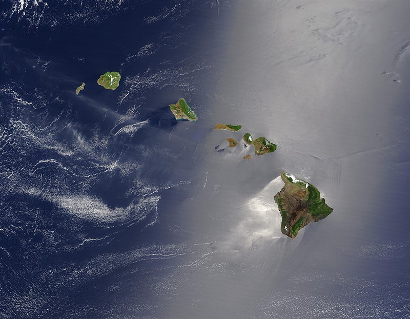
Hawaiian Islands
archipelago in the Pacific Ocean

Quaternary
The Quaternary ( , ) is the current and most recent of the three periods of the Cenozoic Era in the geologic time scale of the International Commission on Stratigraphy (ICS), as well as the current and most recent of the twelve periods of the Phanerozoic eon. It follows the Neogene Period and spans from 2.6 million years ago to the present. The Quaternary Period is divided into two epochs: the Pleistocene (2.6 million years ago to 12 thousand years ago) and the Holocene (12 thousand years ago to today); a proposed third epoch, the Anthropocene, was rejected in 2024 by International Union of Ge

ocean current
continuous flow of ocean water

continental shelf
portion of a continent that is submerged under an area of relatively shallow water known as a shelf sea

sea water
Seawater, or sea water, is water from a sea or ocean. On average, seawater in the world's oceans has a salinity of about 3.5% (35 g/L, 35 ppt, 600 mM). This means that every kilogram (roughly one liter by volume) of seawater has approximately of dissolved salts (predominantly sodium () and chloride () ions). The average density at the surface is 1.025 kg/L. Seawater is denser than both fresh water and pure water (density 1.0 kg/L at ) because the dissolved salts increase the mass by a larger proportion than the volume. The freezing point of seawater decreases as salt concentrati
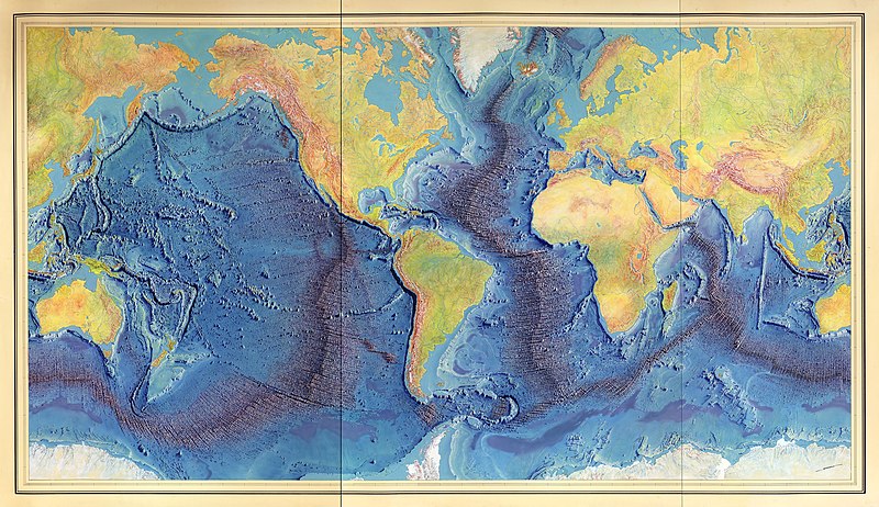
mid-ocean ridge
basaltic underwater mountain system formed by plate tectonic spreading

seamount
Bear Seamount|thumb

shoal
right|thumb|Sandbar between St. Agnes, Isles of Scilly|St Agnes and [[Gugh on the Isles of Scilly, off the coast of Cornwall, England, United Kingdom]]
thumb|A tidal sandbar connecting the islands of Waya Island|Waya and Wayasewa of the [[Yasawa Islands, Fiji]]
thumb|Sandbar between Nosy Iranja Be and Nosy Iranja Kely(Nosy Iranja, [[Madagascar)]]
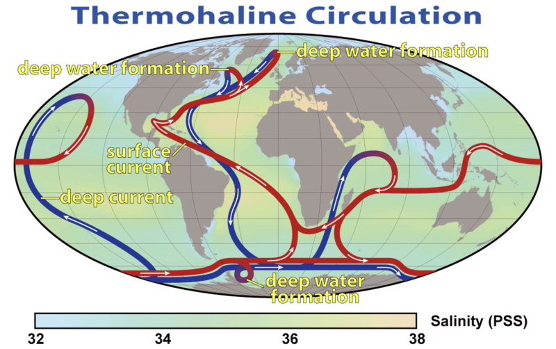
thermohaline circulation
part of the large-scale ocean circulation that is driven by global density gradients created by surface heat and freshwater fluxes

abyssal plain
flat area on the ocean floor

thermocline
thumb|Graph showing a tropical ocean thermocline (depth vs. temperature). Note the rapid change between 100 and 1000 meters. The temperature is nearly constant after 1500 meters depth.

guyot
thumb|right|350px|The Bear Seamount (left), a guyot in the northern [[Atlantic Ocean]]

rip current
narrow current of water which moves directly away from the shore, cutting through the lines of breaking waves
El Niño southern oscillation
irregularly periodic variation in winds and sea surface temperatures over the tropical eastern Pacific Ocean
Puerto Rico Trench
oceanic trench on a transform boundary between the Caribbean and North American Plates
intertidal zone
area between tide marks
Fram Strait
strait
North Atlantic oscillation
weather phenomenon in the North Atlantic Ocean of fluctuations in the difference of atmospheric pressure at sea level between the Icelandic Low and the Azores High
oceanic basin
geologic basin under the sea
ocean bank
part of the sea which is shallow compared to its surrounding area
neritic zone
part of the ocean
Rossby wave
type of inertial wave in the atmospheres and oceans of planets that largely owe their properties to rotation of the planet
barrier island
coastal landform and a type of dune system

halocline
A halocline (or salinity chemocline), from the Greek words hals (salt) and klinein (to slope), refers to a layer within a body of water (water column) where there is a sharp change in salinity (salt concentration) with depth.
physical oceanography
study of physical conditions and physical processes within the ocean
message in a bottle
form of communication
South Sandwich Trench
deep arcuate trench in the South Atlantic Ocean east of the South Sandwich Islands
Hawaiian–Emperor seamount chain
mountain range
hydrothermal circulation
circulation of hot water driven by heat exchange and accompanied by water-rock interactions and alterations

Sound Surveillance System
thumb|upright=1.35|First SOSUS stations
Sound Surveillance System (SOSUS) was the original name for a submarine detection system based on passive sonar developed by the United States Navy to track Soviet submarines. The system's true nature was classified with the name and acronym SOSUS classified as well. The unclassified name Project Caesar was used to cover the installation of the system and a cover story developed regarding the shore stations, identified only as a Naval Facility (NAVFAC), being for oceanographic research. The name changed to Integrated Undersea Surveillance System (IUSS) i

turbidite
thumb|Turbidites are deposited in the deep ocean troughs below the continental shelf, or similar structures in deep lakes, by underwater avalanches which slide down the steep slopes of the continental shelf edge. When the material comes to rest in the ocean trough, it is the sand and other coarse material which settles first followed by mud and eventually the very fine particulate matter. It is this sequence of deposition that creates the Bouma sequences that characterize these rocks.
oceanic plateau
relatively flat submarine region that rises well above the level of the ambient seabed
potential temperature
temperature that a fluid would attain if adiabatically brought to a standard reference pressure
%20resting%20in%20a%20crowd%20on%20Wahlberg%C3%B8ya%2C%20Svalbard%20(3).jpg)
bioturbation
alt=Walrus |thumb|upright=1.5 |Sediment on the left tusk of a walrus. Walrus bioturbations in Arctic benthic sediments have large-scale ecosystem effects.
Pacific decadal oscillation
robust, recurring pattern of ocean-atmosphere climate variability centered over the mid-latitude Pacific basin
longshore drift
geological process by which sediments move along a beach shore
Friendly Floaties
28,800 plastic bath toys

pycnocline
thumb|217x217px|Pycnocline during stable stratification of deep water layers. The pycnocline is the transitory region between a surface layer of water (warmer and less dense) and deeper layer of water (colder and more dense). Mixing occurs across the pycnocline, driven primarily by waves and shear.
A pycnocline is the cline or layer where the density gradient () is greatest within a body of water. An ocean current is generated by the forces such as breaking waves, temperature and salinity differences, wind, Coriolis effect, and tides caused by the gravitational pull of celestial bodies. In add
submarine earthquake
earthquake that occurs underwater at the bottom of a body of water
sea foam
foam created by the agitation of seawater
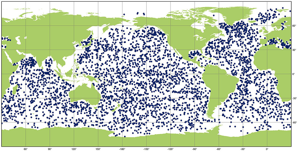
Argo
oceanographic observation system

Jason-1
Jason-1 was a satellite altimeter oceanography mission. It sought to monitor global ocean circulation, study the ties between the ocean and the atmosphere, improve global climate forecasts and predictions, and monitor events such as El Niño and ocean eddies. Jason-1 was launched in 2001 and it was followed by OSTM/Jason-2 in 2008, and Jason-3 in 2016the Jason satellite series. Jason-1 was launched alongside the TIMED spacecraft.
significant wave height
mean wave height of the highest third of the waves

chemocline
A chemocline is a type of cline, a layer of fluid with different properties, characterized by a strong, vertical chemistry gradient within a body of water. In bodies of water where chemoclines occur, the cline separates the upper and lower layers, resulting in different properties for those layers. The lower layer shows a change in the concentration of dissolved gases and solids compared to the upper layer.
.jpg)
OSTM/Jason-2
OSTM/Jason-2, or Ocean Surface Topography Mission/Jason-2 satellite, was an international Earth observation satellite altimeter joint mission for sea surface height measurements between NASA and CNES. It was the third satellite in a series started in 1992 by the NASA/CNES TOPEX/Poseidon mission and continued by the NASA/CNES Jason-1 mission launched in 2001.
geophysical fluid dynamics
fluid dynamics of naturally occurring flows, such as lava flows, oceans, and planetary atmospheres, on Earth and other planets
Wave shoaling
effect by which surface waves entering shallower water change in wave height
dead water
nautical term for a phenomenon which can occur when a layer of fresh or brackish water rests on top of denser salt water, without the two layers mixing
Kaikō
Japanese remotely operated underwater vehicle for deep sea exploration
boundary current
ocean current with dynamics determined by the presence of a coastline

Antarctic Bottom Water
cold, dense, water mass originating in the Southern Ocean surrounding Antarctica
water mass
identifiable body of water with a common formation history which has physical properties distinct from surrounding water
Acoustic Doppler Current Profiler
hydroacoustic current meter used to measure water current velocities over a depth range using the Doppler effect
oceanic zone
part of the ocean beyond the continental shelf
marine heatwave
extended period of anomalously warm water in a region of the oceans
water wave dispersion
water waves of different wavelengths travel at different phase speeds
Milwaukee Deep
deepest part of the Atlantic Ocean – part of the Puerto Rico Trench