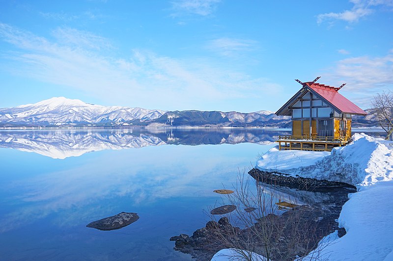
File:Lake_Tazawa_and_Kansa-gū_20210213.jpg · Wikimedia Commons · See Wikimedia Commons
OverviewAI-generated
Akita Prefecture, known in kana as あきたけん, is a Japanese administrative division. It has a total area of 11637.52 square kilometers, with water comprising 0.7 percent of that area. The prefecture is home to a population of 946,380 people.
The official website for the region is titled "美の国あきたネット" (Beautiful Country Akita Net). This site serves as the official portal for Akita Prefecture. The prefecture is referenced by 1,759 other encyclopedia articles. Its social media presence includes 31,402 followers. The suicide rate in the area is recorded at 31.86.
Synthesized by Vinony from 16 facts across 3 sources: Wikidata, Firecrawl, Vinony graph. Generated from structured data (not the Wikipedia text) and checked against those facts — may still contain errors.
Wikidata facts
- Instance of
- prefecture of Japan
- Country
- Japan
- Located in
- Japan
- Contains
- Ogachi district
- Capital
- Akita
- Population
- 946380
- Area
- 11637.52
- Time zone
- UTC+09:00
- Body of water
- Lake Towada
- Head of government
- Kenta Suzuki
- Shares border with
- Aomori Prefecture
- Highest point
- Mount Chōkai
- Official website
- www.pref.akita.lg.jp
- Image
- Akita Prefectural Government Office building No.1 20180520n.jpg
- Significant event
- 1983 Sea of Japan earthquake
Show 20 more facts
- water as percent of area
- 0.7
- Commons category
- Akita prefecture
- topic's main category
- Category:Akita Prefecture
- native label
- 秋田県
- category for people born here
- Category:Births in Akita prefecture
- category of associated people
- Category:People from Akita Prefecture
- Commons gallery
- Akita prefecture
- twinned administrative body
- Primorsky Krai
- lowest point
- Hachirōgata
- official symbol
- Arctoscopus japonicus
- name in kana
- あきたけん
- suicide rate
- 31.86
- replaces
- Yashima Domain
- social media followers
- 31402
- territory overlaps
- Ugo Province
- foods traditionally associated
- kiritanpo
- topic has template
- Template:Akita
- OpenStreetMap zoom level
- 7
- associated electoral district
- Akita 3rd district
Sources (9)
via Wikidata · CC0
~10 min read
Encyclopedic overview
Akita Prefecture (秋田県, Akita-ken; Japanese pronunciation: [aꜜ.kʲi̥.ta, a.kʲi̥.taꜜ.keɴ]) is a prefecture of Japan located in the Tōhoku region of Honshu. Its population is estimated 915,691 as of 1 August 2023 and its geographic area is 11,637 km (4,493 sq mi). Akita Prefecture is bordered by Aomori Prefecture to the north, Iwate Prefecture to the east, Miyagi Prefecture to the southeast, and Yamagata Prefecture to the south.
Akita is the capital and largest city of Akita Prefecture. Other major cities include Yokote, Daisen, and Yurihonjō. Akita Prefecture is located on the coast of the Sea of Japan and extends east to the Ōu Mountains, the longest mountain range in Japan, at the border with Iwate Prefecture. Akita Prefecture formed the northern half of the historic Dewa Province with Yamagata Prefecture.
Excerpted from Wikipedia’s “Akita Prefecture” article, available under the CC BY-SA 4.0 licence.
Gallery (12)
On the map
Available in 94 languages
- Español
- Français
- Deutsch
- 中文
- 日本語
- Русский
- Português
- Italiano
- العربية
- हिन्दी
- Achinese
- Afrikaans
- Aragonese
- Armenian
- azb
- Azerbaijani
- Bahasa Indonesia
- Balinese
Show 75 more
- Bangla
- Basque
- Belarusian
- Bulgarian
- Burmese
- Catalan
- cdo
- Cebuano
- Central Kurdish
- Chechen
- Croatian
- Czech
- Danish
- Esperanto
- Estonian
- Filipino
- Finnish
- Galician
- Gan Chinese
- Georgian
- Hakka Chinese
- Hebrew
- Hungarian
- Iloko
- Irish
- Javanese
- Kannada
- Khmer
- Latvian
- Lithuanian
- Macedonian
- Malay
- Manipuri
- Marathi
- Mingrelian
- Mongolian
- Nederlands
- Nepali
- Northern Frisian
- Northern Sami
- Norwegian
- Novial
- Ossetic
- Pampanga
- Polski
- Punjabi
- Romanian
- Sardinian
- Scots
- Serbian
- Serbian (Latin)
- simple
- Sinhala
- Slovak
- Sundanese
- Svenska
- Swahili
- Tajik
- Tatar
- Tiếng Việt
- Toki Pona
- Türkçe
- Ukrainian
- Urdu
- Uyghur
- Waray
- Welsh
- Western Panjabi
- Wu Chinese
- zh_classical
- zh_min_nan
- zh_yue
- فارسی
- ไทย
- 한국어
via Wikidata sitelinks · CC0