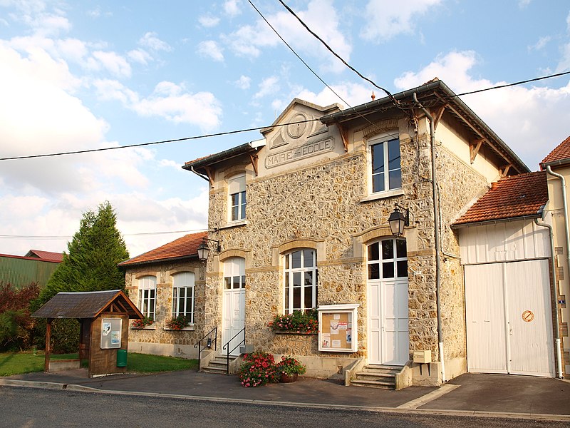
File:Aussonce-FR-08-mairie-03.JPG · Wikimedia Commons · See Wikimedia Commons
Aussonce
Sign in to saveAussonce () is a commune in the Ardennes department in the Grand Est region of north-eastern France.
OverviewAI-generated
Aussonce is a commune in France, situated within the canton of Juniville and the arrondissement of Rethel in the Ardennes department. The area is part of the Grand Est region and shares borders with Juniville, Ménil-Lépinois, La Neuville-en-Tourne-à-Fuy, and Bétheniville. It is associated with the electoral district of the canton of Château-Porcien.
The commune covers an area of 19.14 square kilometers and has an elevation of 170 meters above sea level. Its population is recorded as 236, comprising 101 males and 114 females. Aussonce received the Croix de guerre 1914–1918 award. The postal code for the locality is 08310.
Synthesized by Vinony from 48 facts across 7 sources: Wikidata, Open Meteo, Openweathermap, OpenStreetMap, GeoNames, Vinony graph, Geo. Generated from structured data (not the Wikipedia text) and checked against those facts — may still contain errors.
Weather now
7-day forecast
via Open-Meteo
Key facts
- French commune.name
- Aussonce
- French commune.commune status
- Commune
- French commune.image
- Aussonce-FR-08-mairie-03.JPG
- French commune.caption
- Aussonce Town Hall
- French commune.image coat of arms
- Blason ville fr Aussonce (Ardennes).svg
- French commune.arrondissement
- Rethel
- French commune.canton
- Château-Porcien
- French commune.INSEE
- 08032
- French commune.postal code
- 08310
- French commune.mayor
- Bruno Ponsin
- French commune.term
- 2020–2026
- French commune.intercommunality
- CC Pays Rethélois
- French commune.elevation m
- 86
- French commune.elevation min m
- 94
- French commune.elevation max m
- 170
- French commune.area km2
- 19.14
via Wikipedia infobox
Wikidata facts
- Instance of
- commune of France
- Official name
- Aussonce
- Country
- France
- Located in
- arrondissement of Rethel
- Population
- 236
- Area
- 19.14
- Elevation
- 124
- Time zone
- UTC+01:00
- Shares border with
- Warmeriville
- Image
- Aussonce (08 Ardennes) - l’ Église Saint-Sindulphe - Photo Francis Neuvens lesardennesvuesdusol.fotoloft.fr.JPG
Show 10 more facts
- Commons category
- Aussonce
- postal code
- 08310
- associated electoral district
- canton of Château-Porcien
- male population
- 101
- female population
- 114
- P8168
- Arnold Forstmann
- native label
- Aussonce
- email address
- mailto:[email protected]
- phone number
- +33-3-24-72-73-64
- fax number
- +33-3-24-72-73-64
via Wikidata · CC0
~3 min read
Encyclopedic overview
11 sectionsContents
- Geography
- Neighbouring communes and villages
- History
- Administration
- Demography
- Sites and Monuments
- Notable people linked to the commune
- See also
- Bibliography
- References
- External links
Aussonce () is a commune in the Ardennes department in the Grand Est region of north-eastern France.
==Geography== Aussonce is located some 30 km north-east of Reims and 25 km south of Rethel. The western border of the commune is the departmental border between Ardennes and Marne. Access to the commune is by the D25 road from La Neuville-en-Tourne-à-Fuy in the east which passes through the village then continues west to Heutrégiville, changing to the D33 at the border. The D985 from La Neuville-en-Tourne-à-Fuy to Pontfaverger-Moronvilliers passes through the south-east of the commune. The D15 goes north-west from the village to Ménil-Lépinois. The commune consists entirely of flat farmland.
Excerpted from Wikipedia’s “Aussonce” article, available under the CC BY-SA 4.0 licence.
Gallery (12)
On the map
2 mapped locations