File:Chateau_clavieres-ayrens_ruines_façade.jpg · Wikimedia Commons · See Wikimedia Commons
Ayrens
Sign in to saveAyrens is a commune in the Cantal department in the Auvergne-Rhône-Alpes region of south-central France.
OverviewAI-generated
Ayrens is a commune in France, situated within the canton of Laroquebrou, the arrondissement of Aurillac, and the department of Cantal. It shares borders with Freix-Anglards, Jussac, Saint-Illide, and Saint-Paul-des-Landes. The area covers 25.5 square kilometers and has an elevation of 729 meters above sea level.
The population of Ayrens is 676, comprising 336 males and 316 females. The postal code for the commune is 15250. Its associated electoral district is the canton of Saint-Paul-des-Landes.
Synthesized by Vinony from 41 facts across 7 sources: Wikidata, Openweathermap, OpenStreetMap, GeoNames, Open Meteo, Vinony graph, Geo. Generated from structured data (not the Wikipedia text) and checked against those facts — may still contain errors.
Weather now
cached 21h ago7-day forecast
via Open-Meteo
Place details
- Locality
- Ayrens
- Region
- Auvergne-Rhône-Alpes
- Country
- France
- Population
- 531
via OpenStreetMap · GeoNames
Key facts
- French commune.area km2
- 25.5
- French commune.name
- Ayrens
- French commune.commune status
- Commune
- French commune.image
- Chateau clavieres-ayrens ruines façade.jpg
- French commune.caption
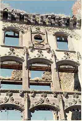
- Ruins of the chateau of Clavières-Ayrens
- French commune.arrondissement
- Aurillac
- French commune.canton
- Saint-Paul-des-Landes
- French commune.INSEE
- 15016
- French commune.postal code
- 15250
- French commune.mayor
- Hubert Bonhommet
- French commune.term
- 2020–2026
- French commune.intercommunality
- CA Aurillac Agglomération
- French commune.elevation min m
- 517
- French commune.elevation max m
- 729
via Wikipedia infobox
Wikidata facts
- Instance of
- commune of France
- Official name
- Ayrens
- Country
- France
- Located in
- arrondissement of Aurillac
- Population
- 618
- Area
- 25.5
- Elevation
- 623
- Time zone
- UTC+02:00
- Shares border with
- Saint-Paul-des-Landes
- Image
- Chateau clavieres-ayrens ruines façade.jpg
Show 9 more facts
- Commons category
- Ayrens
- postal code
- 15250
- native label
- Ayrens
- associated electoral district
- canton of Saint-Paul-des-Landes
- male population
- 336
- female population
- 316
- P8168
- Rolf Hermichen
- email address
- mailto:[email protected]
- phone number
- +33-4-71-46-30-70
Sources (4)
via Wikidata · CC0
~5 min read
Encyclopedic overview
10 sectionsContents
- Geography
- Neighbouring communes and villages
- History
- Administration
- Demography
- Sites and monuments
- Notable people linked to the commune
- See also
- References
- External links
Ayrens is a commune in the Cantal department in the Auvergne-Rhône-Alpes region of south-central France.
==Geography== Ayrens is located some 15 km north-west of Aurillac and 5 km north of Saint-Paul-des-Landes. Access to the commune is by road D52 from Teissières-de-Cornet in the south-east which passes through the village and continues west then south to join the D120 north-east of Laroquebrou. The D53 comes from Saint-Paul-des-Landes in the south and also passes through the village before continuing north-east to join the D6 near the border of the commune. The D352 goes north from the village to join the D53 north of the commune. Apart from the village there are the hamlets of: Les Baraques Le Bos Niac Boutonnet Cels Ciels Colin La Croix-Longue Jammes Le Mont Renac Selves Serieys Tannuies La Tronque
Excerpted from Wikipedia’s “Ayrens” article, available under the CC BY-SA 4.0 licence.
Gallery (6)
On the map
4 mapped locations