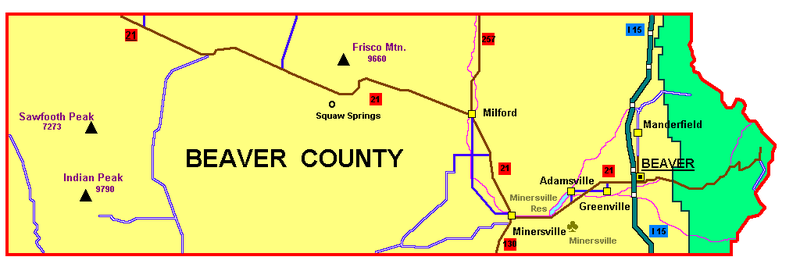
File:Beavercounty_ut.png · Wikimedia Commons · See Wikimedia Commons
Beaver County
Sign in to saveAlso known as Beaver County, Utah, Beaver County, UT
county in southwestern Utah, United States
Beaver County is a county located in southwestern Utah. It matters as part of Utah's regional geography and local governance structure.
AI-generated from the Wikipedia summary — may contain errors.
Key facts
- Country
- United States
- State
- Utah
- Named after
- North American beaver
- Seat
- Beaver
- Largest city
- Beaver
- Total
- 2,592 sq mi (6,710 km )
- Land
- 2,590 sq mi (6,700 km )
- Water
- 2.1 sq mi (5.4 km ) 0.08%
- Estimate 2025
- 7,301
- Density
- 2.73/sq mi (1.05/km )
- Time zone
- UTC−7 ( Mountain )
- Summer dst
- UTC−6 ( MDT )
- Congressional district
- 2nd
- Website
- beaver .utah .gov
via Wikipedia infobox
Official website
Beaver County, UT - Official Website | Official Website
beaver.utah.gov →Create a Website Account Manage notification subscriptions, save form progress and more. Thank you for reaching out to the Beaver County Sheriff’s Office. We understand how stressful it is to wait for news regarding your home, cabin, or land in the path of the Cottonwood Fire. However, at this time, we have absolutely no information regarding what condition your property is in. We are currently not accepting general property checks simply to provide condition updates, and we will not be returning inquiries of that nature. We are currently being inundated by hundreds of these requests, which is severely slowing down our administrative processes and emergency operations. Our field personnel are strictly dedicated to life safety, active evacuations, and supporting wildland fire crews. Because the fire remains highly active, it is not yet safe to send deputies into the canyon to conduct structural assessments. To prepare for when the area is safe to enter, we are asking property owners to submit information as if you have lost property in the wildfire. This will allow us to build an accurate database for official damage assessments. Please note: Because we do not have a dedicated "wildfire portal," we are temporarily utilizing our standard online Witness Statement form as a master ticketing system to track potential property loss. 1. The "Incident Description" box: Type COTTONWOOD FIRE PROPERTY LOSS at the very top in ALL CAPS so our records division can route it to the proper location. 2. Location details: Provide the exact physical address, parcel number, or precise GPS coordinates. If the property sits on an unnamed or private forest road, provide brief driving directions. 3. Structure description: Give us a one-sentence visual description of the primary building (e.g., "Two-story green A-frame with a silver metal roof and a detached wooden deck"). When ground crews eventually assess these zones in heavy smoke, distinct features help us verify property status much faster. 5. Contact info: Double-check your phone number and email address. We recommend checking the box at the bottom that says "Receive an email copy of this form" so you have a timestamped record of your submission. Mapping: Once your form is submitted, your property will be dropped onto our master Incident Command map. Assessment & Contact: The moment the Incident Management Team declares a specific sector safe for local law enforcement to enter, teams will check the logged coordinates and contact you directly via the phone number or email you provided regarding the official status of your property. Keep Lines Clear: Please do not submit multiple forms for the same parcel, and please keep phone lines to the Sheriff's Office clear for active emergency dispatches. For general, high-level updates on the fire's acreage and containment lines, please monitor the Fishlake National Forest official feeds or the Watch Duty tracking app. We ask for your patience and your thoughts for the crews working the line today.
Read more on their site →Excerpt from the official site · 4,284 chars · not written by Vinony
Wikidata facts
- Named after
- Canadian beaver
- Country
- United States
- Located in
- Utah
- Contains
- Beaver
- Capital
- Beaver
- Population
- 7072
- Area
- 6714
- Shares border with
- Iron County
- Official website
- beaver.utah.gov
- Image
- Old Beaver County Ut courthouse.jpg
- Households
- 2213
Show 7 more facts
- Commons category
- Beaver County, Utah
- topic's main category
- Category:Beaver County, Utah
- inception
- 1856-01-05
- different from
- Beaver County
- water as percent of area
- 0.08
- native label
- Beaver County
- per capita income
- 24540
Sources (10)
via Wikidata · CC0
~7 min read
Encyclopedic overview
Beaver County is a county in west central Utah, United States. As of the 2020 United States census, the population was 7,072, up from the 2010 figure of 6,629. Its county seat and largest city is Beaver. The county was named for the abundance of beaver in the area.
History
Excerpted from Wikipedia’s “Beaver County” article, available under the CC BY-SA 4.0 licence.