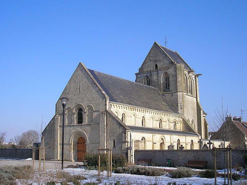
File:FranceNormandieCarpiquetEglise.jpg · Wikimedia Commons · See Wikimedia Commons
Carpiquet
Sign in to saveCarpiquet () is a commune in the Calvados department in the Normandy region in northwestern France. Caen – Carpiquet Airport is located in Carpiquet.
OverviewAI-generated
Carpiquet is a commune in France, situated within the Calvados department and the arrondissement of Caen. It lies in the Normandy region and shares borders with Bretteville-sur-Odon, Caen, Rots, and Saint-Germain-la-Blanche-Herbe. The municipality has an area of 5.88 square kilometers and an elevation above sea level of 74 meters. Its postal code is 14650, and it is part of the canton of Caen-2.
The population of Carpiquet is recorded as 3,428, comprising 1,243 males and 1,364 females. Another source lists the population as 2,040. The official name of the locality is Carpiquet.
Synthesized by Vinony from 51 facts across 8 sources: Wikidata, Openweathermap, Open Meteo, OpenStreetMap, Firecrawl, GeoNames, Vinony graph, Geo. Generated from structured data (not the Wikipedia text) and checked against those facts — may still contain errors.
Weather now
7-day forecast
via Open-Meteo
Place details
- Locality
- Carpiquet
- Region
- Normandie
- Country
- France
- Population
- 2,040
via OpenStreetMap · GeoNames
Key facts
- French commune.name
- Carpiquet
- French commune.commune status
- Commune
- French commune.image
- FranceNormandieCarpiquetEglise.jpg
- French commune.caption
- The church in Carpiquet
- French commune.arrondissement
- Caen
- French commune.canton
- Caen-2
- French commune.INSEE
- 14137
- French commune.postal code
- 14650
- French commune.mayor
- Pascal Sérard
- French commune.term
- 2020–2026
- French commune.intercommunality
- CU Caen la Mer
- French commune.elevation m
- 64
- French commune.elevation min m
- 45
- French commune.elevation max m
- 74
- French commune.area km2
- 5.88
via Wikipedia infobox
Official website
Carpiquet - Site officiel de la commune de Carpiquet
Bienvenue sur le site officiel de Carpiquet. Retrouvez toutes les informations sur la commune l’actu, l’agenda, l’annuaire et les projets.
carpiquet-mairie.fr →Link to the official site · 7,082 chars · not written by Vinony
Wikidata facts
- Instance of
- commune of France
- Official name
- Carpiquet
- Country
- France
- Located in
- arrondissement of Caen
- Population
- 3428
- Area
- 5.88
- Elevation
- 60
- Time zone
- UTC+02:00
- Shares border with
- Rots
- Official website
- www.carpiquet.fr
- Image
- FranceNormandieCarpiquetEglise.jpg
Show 9 more facts
- Commons category
- Carpiquet
- postal code
- 14650
- associated electoral district
- canton of Caen-2
- male population
- 1243
- female population
- 1364
- P8168
- Theodor Michael
- email address
- mailto:[email protected]
- phone number
- +33-2-31-71-20-20
- fax number
- +33-2-31-26-09-39
via Wikidata · CC0
Travel guide
Understand
thumb|Canadians in Carpiquet, July 12, 1944 Caen is a modern city; four-fifths of it was demolished in 1944 and rebuilt in the 1950s and 1960s. However, some old buildings remain, especially churches.
In summer, tourists (mainly British and German) gather in Normandy for Second World War memorials and the Memorial for Peace. Caen is an excellent base for visits to the D-Day beaches.
There was intense fighting in Caen and the surrounding area starting shortly after the D-Day landings] on June 6, 1944. The village of Carpiquet, which is a bit west of Caen near the ring road and the E46 highway, has the Caen airport so it was strategically important and also saw heavy fighting.
Get around
The bus verts will get you around Normandy easily. Within Caen and its close suburbs, use the bus and tramway network, called twisto. The tram system consist of 3 lines, two of which pass the SNCF railway station. The tourist information centre in central Caen provides timetables and excellent maps of the city's public transport network.
thumb|250px|Trams at Place Saint-Pierre
See
thumb|Part of the Château de Caen thumb|Mairie (Town Hall) La rue Froide and .
Do
D-Day beaches. Caen is close enough to the D-Day sites to act as a base from which to explore the D-Day sites. It is a short train ride from Caen to Bayeux. From Bayeux train station, you can catch a bus to some of the D-Day beaches but services are infrequent; if you want to see more than one of the beaches you should rent a car or join a guided tour. On the bus website there is a map of the bus route to the D-Day beaches. Bus No. 70 takes you to Omaha beach, the American cemetery, and to Pointe Du Hoc. Bus No. 74 takes you to Arromanches beach, the location of the Mulberry harbours. Buses are few and far between. Many companies offer guided tours to the battle sites from Caen or Bayeux, and the Memorial for Peace runs half-day tours of the landing beaches. Football: SM Caen were relegated in 2025 and now play soccer in Championnat National, the third tier. Their home ground Stade Michel d'Ornano (capacity 20,300) is 3 km west of city centre. Caen Student Carnival : Europe's biggest student festival. It usually takes place in March or April. Created in 1894, it attracts around 35,000 students every year. For the occasion, carnival-goers dress up and gather on the Esplanade de la Paix on Campus 1 before parading through the city's most emblematic sites. The carnival culminates in a concert organised by the national radio station NRJ.
Buy
Shopping centres: Les Rives de l'Orne (a shopping centre next to the train station), Mondeville 2 and Mondevillage in Mondeville (a neighbouring town accessible by bus), and Carrefour Mall in Hérouville Saint Clair (a neighbouring town accessible by tram and bus).
Eat
Caen's local delicacy is called tripes à la mode de Caen - tripe and vegetables stewed in cider - and is nicer than it sounds. The official recipe, closely guarded by a guild of tripe butchers, is written in the form of a poem. The Vaugueux is full of restaurants.
Drink
The Rue Ecuyère, near to the Rue Saint Pierre is famous for its bars. If you are looking for a pub, you will find some at the harbour located Quai Vendeuve.
Go next
The little 17th-century harbor of Honfleur (65 km north-east) The Pays d'Auge, typical landscapes and villages, horse farms (Le Haras du Pin is the most famous one), cheeses, cider, Roman churches and half-timbered houses Deauville, the century-old-sea resort for the upper-class The world-famous Mont-Saint-Michel, at the frontier between Normandy and Brittany The Channel Islands (Jersey, Guernsey) The little sea resort of Granville The fabulous landscapes of the Cotentin area Caen is away from the D-Day beaches
Travel guide from Wikivoyage (CC BY-SA 4.0)
~2 min read
Encyclopedic overview
12 sectionsContents
- Geography
- History
- Population
- Points of interest
- National heritage sites
- Economy
- Sport
- International relations
- Twin towns – sister cities
- See also
- References
- External links
Carpiquet () is a commune in the Calvados department in the Normandy region in northwestern France. Caen – Carpiquet Airport is located in Carpiquet.
==Geography== Carpiquet is on the western side of the Caen metropolitan area. The town is divided into four distinct areas: the town centre; the commercial area along the Ligne de Paris - Caen and Route nationale 13 to the north; the Bellevue area to the east; the Caen - Carpiquet Airport to the west.
Excerpted from Wikipedia’s “Carpiquet” article, available under the CC BY-SA 4.0 licence.
Gallery (4)
On the map
3 mapped locations