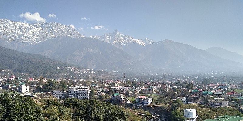
File:Dharamshala_03_(Cropped).jpg · Wikimedia Commons · See Wikimedia Commons
Dharamshala
Sign in to saveAlso known as Bhagsu, Dharamsala, Dharamshala, Himachal Pradesh
Dharamshala (, ; also spelled Dharamsala) is a town in the Indian state of Himachal Pradesh. It serves as the winter capitalof the state and the administrative headquarters of the Kangra district since 1855. The town also hosts the 14th Dalai Lama and the Tibetan government-in-exile. Dharamshala was a municipal council until 2015, when it was upgraded to a municipal corporation.
OverviewAI-generated
Dharamshala is a city in Kangra district, Himachal Pradesh, India, serving as the district capital. It is situated at an elevation of 1,457 meters above sea level and covers an area of 29.51 square kilometers. The city’s official name is also written as Dharamsala, and it is located in the UTC+05:30 time zone.
The population of Dharamshala is recorded as 19,034 in one source and 30,764 in another. The local postal code is 176215, and the dialing code is 1892. The city is described in the 11th edition of the Encyclopædia Britannica.
Synthesized by Vinony from 49 facts across 7 sources: Wikidata, Open Meteo, Openweathermap, OpenStreetMap, GeoNames, Vinony graph, Geo. Generated from structured data (not the Wikipedia text) and checked against those facts — may still contain errors.
Weather now
cached 6h ago7-day forecast
via Open-Meteo
Place details
- Locality
- Dharamshala
- Region
- Himachal Pradesh
- Country
- India
- Population
- 30,764
- Timezone
- Asia/Kolkata
via OpenStreetMap · GeoNames
Key facts
- Settlement.name
- Dharamshala
- Settlement.other_name
- Dharamsala
- Settlement.settlement_type
- Town
- Settlement.image_caption
- From top, left to right: Skyline of Dharamsala, Mcleodganj during winter, Triund, Bhagsunag Temple, Kalachakra Temple, HPCA Stadium
- Settlement.nickname
- Dhasa
- Settlement.pushpin_map
- India Himachal Pradesh#India
- Settlement.pushpin_label_position
- right
- Settlement.pushpin_map_caption
- Location within the Indian state of Himachal Pradesh##Location within India
- Settlement.subdivision_type
- Country
- Settlement.subdivision_type1
- State
- Settlement.subdivision_type2
- District
- Settlement.subdivision_name1
- Himachal Pradesh
- Settlement.subdivision_name2
- Kangra
- Settlement.named_for
- Derives its name from an old Hindu sanctuary, called Dharamsàla which once stood there.
- Settlement.seat_type
- Member of legislative Assembly
- Settlement.seat
- Sudhir Sharma
- Settlement.government_type
- Municipal Corporation
- Settlement.governing_body
- Dharamshala Municipal Corporation
via Wikipedia infobox
Wikidata facts
- Instance of
- city
- Official name
- Dharamsala
- Country
- India
- Located in
- Kangra district
- Population
- 19034
- Area
- 29.51
- Elevation
- 1457
- Time zone
- UTC+05:30
- Capital of
- Kangra district
- Official website
- himachaltourism.gov.in/destination/dharamshala
- Image
- Dharamshala 03 (Cropped).jpg
- Dialing code
- 1892
Show 7 more facts
- topic's main category
- Category:Dharamshala
- Commons category
- Dharamshala
- Commons gallery
- Dharamshala
- postal code
- 176215
- native label
- Dharamsala
- described by source
- Encyclopædia Britannica 11th edition
Sources (3)
via Wikidata · CC0
Travel guide
Understand
The Tibetan Buddhist roots of Dharamsala stretch back to the 8th century, although most of the local population long since reverted to (and remains) Hindu. "Dharamsala" literally means an "inn attached to a temple", and it was so until the district headquarters in Kangra became too crowded and the British moved 2 of their regiments in the late 1840s to what is now Dharamsala. Over the years, this grew to be district headquarters of Kangra, and the location is now known as the Police Lines.
Dharamsala was mooted to be the summer capital of India. But this was not to be, as much of the town was destroyed in the 7.8 magnitude earthquake of 4 April 1905. The disaster killed over 10,000 people in this sparsely populated area.
After falling into obscurity in the early days of Indian independence, Dharamsala regained some social standing in 1959 with the arrival of the Dalai Lama and the Tibetan Government in Exile. It is a very popular hang-out for foreigners and students of Buddhism. Indeed, it is now perhaps a little too popular and many would say the town, and especially McLeod Ganj, is little more than a backpacker ghetto. Don't come here expecting calm and tranquillity.
Get around
thumb|370px|Map of McLeod Ganj
See
thumb|201x201px|Giant prayer wheel and thangka of Arya Sitatapatra, a form of Tara, at Tsuglagkhang thumb|View of Dhauladhar Range from HPCA Stadium Dharamshala thumb|Dhauladhar Range from Naddi viewpoint thumb|St John Cathedral in the Wilderness
Buy
Many Tibetan things can be bought in Dharamsala such as jewellery and trinkets, woollen shawls, prayer flags, prayer wheels, carpets, thangka and mandala paintings.
Drink
Refill your waterbottle with filtered-water at one of the many water-filtering stations: LHA at Temple Rd, Environmental Education Centre at Bhasgu Rd and Dogga-Centre at Jogiwara Rd. Some restaurants, including Nick's and Green Hotel also offer filtered water refills for a charge (₹5, but Green Hotel asks for ₹10).
Sleep
McLeod Ganj has a wide selection of accommodation, but its main streets (esp. Bhagsu Rd) suffer from the usual Indian curse of beeping cars, motorbikes and rickshaws. It is easy to find something suitable—just walk around and ask for a good price. Always let you show at least two different rooms before you decide. Two hostels worth mentioning in McLeod Ganj are and —walk-ins seem to be advantageous.
A higher concentration of hostels (and backpackers) can be found in Bhagsu and Haini, besides the usual homestays, hotel, etc.. Hostels worth mentioning here are and —walk-ins seem to be advantageous.
For long-term stays, head down the Yongling stairs on Jogiwara Road; there are about a dozen cheap good places, with great views.
Stay safe
The place is safe, though it is advisable to take precautions. Stay vigilant at all times and be very cautious if staying out after 9PM.
Go next
Amritsar – The holy Sikh city of and its Golden Temple is a 6-hr bus journey away. Buses leave at 5AM from the lower bus station, or go through Pathankot first with many connections per day, and a train from there. Bir – A village with a Tibetan and Indian population, known for its Buddhist monasteries and paragliding centre, developing as an adventure hub with the second highest paragliding spot of the world, Bir-Billing. Dalhousie – A small hill station close to Pathankot. Manali – The next hub for journeys deeper into the mountains. Palampur – A beautiful valley famous for its tea gardens, agricultural university, temples. Sidhbari – Outside lower Dharamshala is an ideal getaway from the tourist traffic and to experience life in a typical farming village in the valley.
la:Dharmasala
Travel guide from Wikivoyage (CC BY-SA 4.0)
~16 min read
Encyclopedic overview
20 sectionsContents
- Etymology
- History
- Early history
- British occupation
- Post independence
- Geography
- Climate
- Demographics
- Administration and politics
- Economy
- Culture and attractions
- Transport
- Road
- Air
- Rail
- Ropeway
- Education
- Notable people
- References
- External links
Dharamshala (, ; also spelled Dharamsala) is a town in the Indian state of Himachal Pradesh. It serves as the winter capitalof the state and the administrative headquarters of the Kangra district since 1855. The town also hosts the 14th Dalai Lama and the Tibetan government-in-exile. Dharamshala was a municipal council until 2015, when it was upgraded to a municipal corporation.
The town is located in the Kangra Valley, in the shadow of the Dhauladhar range of the Himalayas at an altitude of . References to Dharamshala and its surrounding areas are found in ancient Hindu scriptures such as Rig Veda and Mahabharata. The region was under Mughal influence before it was captured by the Sikh Empire in 1785. The East India Company captured the region for the British following the First Anglo-Sikh War of 1846, from when it became part of the British Indian province of the Punjab. Post Indian Independence in 1947, it remained as a small hill station. In 1960, the Central Tibetan Administration was moved to Dharamshala when the 14th Dalai Lama established the Tibetan administration-in-exile after he had to flee Tibet.
Excerpted from Wikipedia’s “Dharamshala” article, available under the CC BY-SA 4.0 licence.
Gallery (20)
On the map
3 mapped locations
Available in 74 languages
- Español
- Français
- Deutsch
- 中文
- 日本語
- Русский
- Português
- Italiano
- العربية
- हिन्दी
- Afrikaans
- Bahasa Indonesia
- Bangla
- Basque
- Bhojpuri
- Bishnupriya
- Bulgarian
- Catalan
Show 55 more
- Cebuano
- Czech
- Danish
- Dzongkha
- Egyptian Arabic
- Esperanto
- Estonian
- Filipino
- Finnish
- Georgian
- Greek
- Gujarati
- Hebrew
- Hungarian
- Kannada
- Latin
- Latvian
- Lithuanian
- lld
- Malay
- Malayalam
- Marathi
- Mongolian
- Nederlands
- Nepali
- Newari
- Northern Frisian
- Norwegian
- Occitan
- Pampanga
- Polski
- Punjabi
- Romanian
- Sanskrit
- Santali
- Silesian
- simple
- Slovak
- Svenska
- Tamil
- Telugu
- Tibetan
- Tiếng Việt
- Türkçe
- Ukrainian
- Urdu
- Waray
- Welsh
- Western Panjabi
- Wu Chinese
- zh_min_nan
- zh_yue
- فارسی
- ไทย
- 한국어
via Wikidata sitelinks · CC0