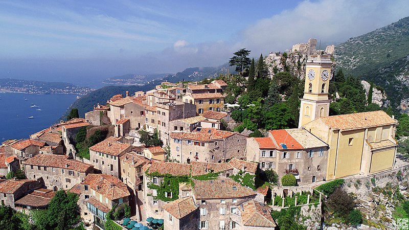
File:Èze_Alpes_Maritimes_France_(261171069).jpeg · Wikimedia Commons · See Wikimedia Commons
Èze (; ; ) is a seaside commune in the Alpes-Maritimes department in the Provence-Alpes-Côte d'Azur region in Southeastern France. It is located on the French Riviera, 8.5 km (5.2 mi) to the northeast of Nice and 4.5 km (2.7 mi) to the west of Monaco. In 2018, Èze had 2,225 inhabitants known as Ezasques (masculine and feminine).
OverviewAI-generated
Èze is a commune in France, situated within the Provence-Alpes-Côte d'Azur region. It lies in the arrondissement of Nice and the canton of Villefranche-sur-Mer, with an associated electoral district in the canton of Beausoleil. The municipality borders Cap-d'Ail, Nice, La Trinité, and La Turbie, and is located next to the Mediterranean Sea.
The area of the commune is 9.47 square kilometers. Population figures vary by source, with one listing 2,932 residents and another citing 2,610. The male population is recorded as 1,088, while the female population is 1,151. Elevation data also differs, with one source indicating 700 meters above sea level and another listing 393 meters. The postal code for the area is 06360, and it uses the license plate code 06.
Synthesized by Vinony from 51 facts across 8 sources: Wikidata, Openweathermap, OpenStreetMap, GeoNames, Firecrawl, Open Meteo, Vinony graph, Geo. Generated from structured data (not the Wikipedia text) and checked against those facts — may still contain errors.
Weather now
7-day forecast
via Open-Meteo
Place details
- Locality
- Èze
- Region
- Provence-Alpes-Côte d'Azur
- Country
- France
- Population
- 2,610
- Timezone
- Europe/Paris
via OpenStreetMap · GeoNames
Key facts
- French commune.name
- Èze
- French commune.commune status
- Commune
- French commune.image
- Èze Alpes Maritimes France (261171069).jpeg
- French commune.caption
- A view of Èze
- French commune.arrondissement
- Nice
- French commune.canton
- Beausoleil
- French commune.INSEE
- 06059
- French commune.postal code
- 06360
- French commune.mayor
- Stéphane Cherki
- French commune.term
- 2020–2026
- French commune.intercommunality
- Métropole Nice Côte d'Azur
- French commune.elevation min m
- 0
- French commune.elevation max m
- 700
- French commune.area km2
- 9.47
- French commune.website
- https://ville-eze.fr
via Wikipedia infobox
Official website
Accueil - Site officiel de la Mairie d'Eze
ville-eze.fr →Link to the official site · 4,520 chars · not written by Vinony
Wikidata facts
- Instance of
- commune of France
- Official name
- Èze
- Country
- France
- Located in
- arrondissement of Nice
- Population
- 2144
- Area
- 9.47
- Elevation
- 359
- Time zone
- UTC+02:00
- Body of water
- Mediterranean Sea
- Shares border with
- Villefranche-sur-Mer
- Official website
- ville-eze.fr
- Image
- Eze-Village-PACA-France.jpg
- Licence plate code
- 06
- Motto
- Moriendo renascor
Show 11 more facts
- Commons category
- Èze
- Commons gallery
- Èze
- topic's main category
- Category:Èze
- postal code
- 06360
- associated electoral district
- canton of Beausoleil
- male population
- 1088
- female population
- 1151
- P8168
- Dellach
- email address
- mailto:[email protected]
- phone number
- +33-4-92-10-60-60
- fax number
- +33-4-92-10-60-50
via Wikidata · CC0
Travel guide
Get in
The commune is mainly crossed from west to east by 3 roads: The "route du bord de mer" (sea-side road) or "Basse corniche" running along the whole coast of the département, passes through Èze-sur-Mer. Èze village is located on the road called "Moyenne corniche" (M6007), also known as a part of the "Route nationale 7" (the Holiday Route, running from Paris to Italy). As its name says, it runs halfway on the mountain-side. The "Grande corniche" (D 2564; called avenue des diables bleus on the portion over Èze village) runs on top of the ridge between Nice and Menton.
Get around
A long steep footpath, the Chemin de Nietzsche, connects the seaside town (and train station) with the village. The path is rough and rocky, so hiking shoes or boots are recommended. The walk up will take about 1.5 hours. The walk downhill (from Èze to Eze-sur-Mer) takes 45 minutes.
If you want to do the route by car you will have to make a detour. There is a direct road from Èze village to the grande corniche.
See
thumbnail|A typical street of the village
Do
Caves Hiking Make your own perfume at the Galimard or Fragonard perfumeries
Go next
The city-state of Monaco is 5 km east. Nice, the main city of the département, is about 7 km west. La Turbie, another small village to the east on the Grande corniche road, offers very nice views on Monaco and the coast from the point called the «Tête de chien» (dog head).
Travel guide from Wikivoyage (CC BY-SA 4.0)
~5 min read
Encyclopedic overview
7 sectionsContents
- History
- Geography
- Demographics
- Tourism
- See also
- References
- External links
Èze (; ; ) is a seaside commune in the Alpes-Maritimes department in the Provence-Alpes-Côte d'Azur region in Southeastern France. It is located on the French Riviera, 8.5 km (5.2 mi) to the northeast of Nice and 4.5 km (2.7 mi) to the west of Monaco. In 2018, Èze had 2,225 inhabitants known as Ezasques (masculine and feminine).
==History==
Excerpted from Wikipedia’s “Èze” article, available under the CC BY-SA 4.0 licence.
Gallery (11)
On the map
2 mapped locations