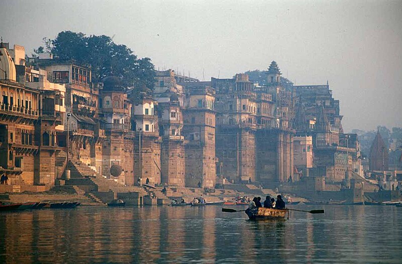
File:Varanasiganga.jpg · Wikimedia Commons · See Wikimedia Commons
Also known as Ganga, Ganges River, River Ganges, Ganga Nadi
南亚河流
The Ganges is a major river that flows through India and Bangladesh, originating in the western Himalayas and traveling through North India's plains while collecting water from numerous tributaries along the way. It holds deep significance as India's National River and plays a crucial role in the region's geography and water systems.
AI-generated from the Wikipedia summary — may contain errors.
Key facts
- River.subdivision_name5
- Uttarakhand: Rishikesh & Haridwar Uttar Pradesh: Bijnor, Garhmukteshwar, Anupshahr, Farrukhabad, Fatehgarh, Kannauj, Kanpur, Fatehpur, Kunda, Prayagraj, Mirzapur, Varanasi, Mughalsarai, Ghazipur & Ballia Bihar: Chausa, Buxar, Chhapra, Danapur, Patna, Hajipur, Barh, Mokama, Begusarai, Munger, Sultanganj, Bhagalpur & Manihari Jharkhand: Sahibganj West Bengal: Murshidabad, Palashi, Nabadwip, Shantipur, Kolkata, Serampore, Chinsurah, Baranagar, Diamond Harbour, Haldia, Budge Budge, Howrah, Uluberia & Barrackpore Rajshahi Division: Rajshahi, Pabna, Ishwardi Khulna Division: Kushtia, Shilaidaha Dhaka Division: Dhaka, Narayanganj, Gazipur, Munshiganj, Faridpur Chittagong Division: Chandpur, Noakhali Barisal Division: Bhola
- River.discharge3_location
- Farakka Barrage
- River.discharge2_location
- Ganges Delta, Bay of Bengal
- River.discharge2_avg
- (Ganges without Brahmaputra and Meghna)
- River.source1
- Confluence at Devprayag, Uttarakhand of the Alaknanda river (the source stream in hydrology because of its greater length) and the Bhagirathi river (the source stream in Hindu tradition). The headwaters of the river include: Mandakini, Nandakini, Pindar and the Dhauliganga, all tributaries of the Alaknanda.
- River.source1_location
- Devprayag, the beginning of the main stem of the Ganges
- River.mouth
- Bay of Bengal
- River.mouth_location
- Ganges Delta
- River.tributaries_left
- Ramganga, Garra, Gomti, Tamsa Ghaghara, Gandak, Burhi Gandak, Koshi, Mahananda
- River.tributaries_right
- Yamuna, Tamsa (also known as Tons River), Karamnasa, Sone, Punpun, Falgu, Kiul, Chandan, Ajay, Damodar, Rupnarayan
- River.mapframe
- yes
- River.discharge1_location
- Mouth of the Ganges
- River.discharge1_avg
- Total runoff into the Bay of Bengal (Period: 1921–1985) (Period: 1990–2020) (dry period 38,129 m³/s, wet period 53,170 m³/s;)
- River.name
- Ganges (Ganga)
- River.name_etymology
- Ganga (goddess)
- River.image
- Varanasiganga.jpg
- River.image_size
- 300px
- River.image_caption
- The Ganges in Varanasi
via Wikipedia infobox
Wikidata facts
- Named after
- Gangā
- Country
- India
- Continent
- Asia
- Elevation
- 9
- Image
- View of Ghats across the Ganges, Varanasi.jpg
- Length
- 2525
Show 12 more facts
- mouth of the watercourse
- Bay of Bengal
- Commons category
- Ganges River
- topic's main category
- Category:Ganges
- category for the water basin
- Category:Ganges basin
- described by source
- Pauly–Wissowa
- watershed area
- 1060000
- discharge
- 12000
- origin of the watercourse
- Gangotri Glacier
- drainage basin
- Ganges Basin
- on focus list of Wikimedia project
- Wikipedia:Vital articles/Level/4
- basin country
- India
- different from
- Ganges
via Wikidata · CC0
Article · 中文
恆河(梵語:गङ्गा,印地語:गंगा,乌尔都语:گنگا(Ganga)国际音标发音:[ˈɡəŋɡaː] ();坦米爾語:கங்கை,孟加拉語:গঙ্গা Gônga,玄奘譯為殑伽河)是南亚的一条主要河流,流經印度北部及孟加拉国。恒河全长2,525公里,流域面积91万平方公里,达印度国土面积的三分之一,恆河也為世界河水流量前20大的河流之一。 恆河流域為世界上最多人口居住的河流流域,有超过4亿人口生活于此,人口密度達每平方公里390人以上。 恒河干流始于帕吉勒提河和阿勒格嫩达河在德沃普拉耶格的交汇。它横越北印度平原(即恒河平原),流经北方邦,与其最大支流亚穆纳河汇合,再流经比哈尔邦、西孟加拉邦,最后分为多条分流注入孟加拉湾。在西孟加拉邦,恒河南岸的一条人工水道将大约50%的水流引向了加尔各答附近的胡格利河,剩余继续流往孟加拉国的部分被称为博多河。博多河进入孟加拉国后与布拉马普特拉河(中国境内为雅鲁藏布江)下游的贾木纳河汇合,最终注入孟加拉湾,其入海河段称为梅格纳河,并在入海区域形成恒河三角洲。 恒河对生活于其流域中的数百万居民至关重要,他们依赖恒河获取生活必需。 過去许多省會及帝國首都曾設於恆河沿岸,如巴连弗邑、曲女城、瓦拉納西、安拉阿巴德、穆尔斯希达巴德、蒙格埃尔、巴哈拉姆普尔、加爾各答等。恒河中生活着大约140种鱼类,90种两栖动物,以及一些爬行动物和哺乳动物,例如极危物种恒河鳄和恒河豚。 恆河被印度教徒視為聖河,印度教中也有稱為「恒河女神」的神祇。 如今,恒河被,对其流域内的人类与动物的生存造成了严峻威胁。在瓦拉納西河段測得的水中水平超過印度政府所訂標準值100倍以上。 印度政府曾发起「」,但由於貪汙、技術不足、缺乏良好環境計畫、印度傳統信仰及缺乏宗教上的有利支持等因素,至今仍遭受重大挫敗。
Abstract from DBpedia / Wikipedia · CC BY-SA
Gallery (52)
On the map
Available in 169 languages
- Español
- Français
- Deutsch
- 中文
- 日本語
- Русский
- Português
- Italiano
- العربية
- हिन्दी
- abstract
- Afrikaans
- Albanian
- Albanian
- Amharic
- Angika
- Aragonese
- Armenian
Show 150 more
- Assamese
- Asturian
- Awadhi
- azb
- Azerbaijani
- Bahasa Indonesia
- Balinese
- Bangla
- Bashkir
- Basque
- bat_smg
- Bavarian
- be_x_old
- Belarusian
- Bhojpuri
- Bikol
- Bosnian
- Breton
- Bulgarian
- Buriat
- Burmese
- Catalan
- cdo
- Cebuano
- Central Kurdish
- Chechen
- Chuvash
- Cornish
- Corsican
- Crimean Tatar
- Croatian
- Czech
- Danish
- Divehi
- Egyptian Arabic
- Esperanto
- Estonian
- Extremaduran
- Fiji Hindi
- Filipino
- Finnish
- Galician
- Georgian
- Gorontalo
- Greek
- Guarani
- Gujarati
- Hebrew
- Hungarian
- Icelandic
- Ido
- Iloko
- Ingush
- Interlingua
- Irish
- Javanese
- Kabardian
- Kannada
- Kara-Kalpak
- Karachay-Balkar
- Kazakh
- kbp
- kge
- Khmer
- Kurdish
- Kyrgyz
- Lao
- Latin
- Latvian
- Lezghian
- Limburgish
- Lingua Franca Nova
- Lithuanian
- Lombard
- Low German
- Luxembourgish
- Macedonian
- Maithili
- Malagasy
- Malay
- Malayalam
- Manipuri
- Marathi
- Mazanderani
- Mingrelian
- Mongolian
- Nederlands
- Nepali
- Newari
- Northern Frisian
- Norwegian
- Norwegian Nynorsk
- Nyanja
- Occitan
- Odia
- Old English
- Ossetic
- Pashto
- Piedmontese
- Polski
- Punjabi
- roa_tara
- Romanian
- Rusyn
- Sanskrit
- Santali
- Serbian
- Serbian (Latin)
- Sicilian
- simple
- Sindhi
- Sinhala
- skr
- Slovak
- Slovenian
- Svenska
- Swahili
- szy
- Tajik
- Talysh
- Tamil
- Tatar
- Telugu
- Tibetan
- Tiếng Việt
- Tulu
- Türkçe
- Turkmen
- Ukrainian
- Upper Sorbian
- Urdu
- Uyghur
- Uzbek
- Venetian
- Veps
- Volapük
- Waray
- Welsh
- Western Frisian
- Western Panjabi
- Wu Chinese
- Yakut
- Yiddish
- Zaza
- zh_classical
- zh_min_nan
- zh_yue
- فارسی
- ไทย
- 한국어
via Wikidata sitelinks · CC0