Huaraz
Sign in to saveHuaraz () (from Quechua: Waraq or Warash, "dawn"), formerly designated as San Sebastián de Huaraz, is a city in Peru. It is the capital of the Ancash Region (State of Ancash) and the seat of government of Huaraz Province. The urban area's population is distributed over the districts of Huaraz and Independencia. The city is located in the middle of the Callejon de Huaylas valley and on the right side of the Santa river. The city has an elevation of approximately 3050 meters above sea level. The built-up area covers 8 square kilometers and has a population of 120,000 inhabitants, making it the s
AI overview
Huaraz is a city in Peru's Ancash Region, located at high altitude in the Callejon de Huaylas valley with a population of about 120,000 people. As the capital and administrative center of Ancash Region and Huaraz Province, it serves as a major urban hub in the Peruvian highlands.
AI-generated from the Wikipedia summary — may contain errors.
Weather now
cached 21h ago12°overcast clouds
78% 0.7 m/s OpenWeatherMap
7-day forecast
via Open-Meteo
Place details
- Locality
- Huaraz
- Region
- Ancash
- Country
- Perú
- Population
- 118,836
- Timezone
Article
29 sectionsContents
- Etymology
- Geography
- Location
- Orography
- Layout
- Neighborhoods
- Climate
- History
- Pre-Columbian era
- Colonial era
- Contemporary times
- Demographics
- Economy
- Sports and recreation
- Sports
- Transportation
- Roads
- Public transportation
- Air transportation
- Tourism
- Culture
- Museum and the arts
- Cuisine
- Media
- Newspapers
- English language newspaper
- See also
- References
- External links
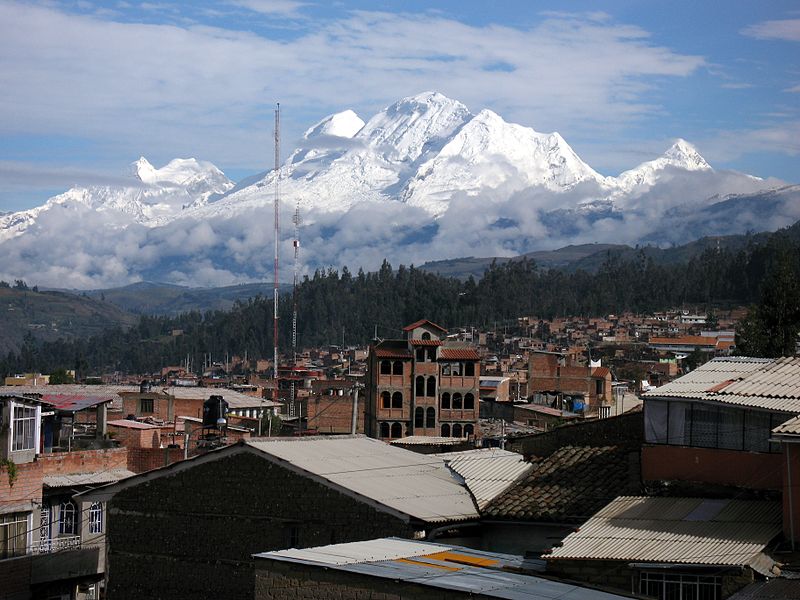
{{Infobox settlement | official_name = Huaraz | other_name = San Sebastián de Huaraz | type = City | native_name = | nickname = | motto = The noble and generous City, Capital of International Friendship, Natural Paradise of the World | image_flag = Bandera de Huaraz.svg | image_shield = Escudo de Huaraz.svg | image_skyline = | image_caption = Top: White mountain range, Second left: La Soledad neighborhood, Second right: Gamarra Avenue, Third left: Residential street in Huarupampa suburb, Third right: Building development, Bottom: Cultural Center and Municipal Theater | image_map = | map_caption = Location in Peru | pushpin_map = Peru | pushpin_label_position = | subdivision_type = Country | subdivision_name = | subdivision_type1 = Region | subdivision_name1 = Ancash | subdivision_type2 = Province | subdivision_name2 = Huaraz | government_type = Democracy | leader_title = Mayor | leader_name = Eliseo Rori Mautino Ángeles(2019–2022) | established_title = Founded | established_date = 20 January 1574 | area_magnitude = | area_footnotes = | area_total_km2 = 370.03 | pop_est_as_of = 2015 | pop_est_footnotes = | population_est = 127041 | population_as_of = 2017 census | population_footnotes = | population_note = | population_total = 118836 | population_density_km2 = auto | timezone = PET | utc_offset = -5 | timezone_DST = PET | utc_offset_DST = -5 | coordinates = | elevation_footnotes =
On 31 May 1970 the same reservoir dam burst during the Ancash earthquake, which had a moment magnitude of 7.9 and a maximum Mercalli intensity of VIII (Severe). Down the creek valley, again came an avalanche, eerily similar to that of 1941. In the prior four years or so, the suburb had begun to again be redeveloped: numerous residences were built atop the 1941 avalanche deposit within the at-risk creek valley. Within its duration of 45 seconds, virtually every structure of consequence in the city's center was destroyed. A few minutes later, the north half of the city, particularly in the creek valley, was obliterated by an avalanche of icy mud carrying boulders and other debris.