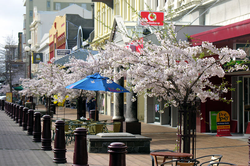
File:Spring_in_Esk_Street_-_Invercargill.jpg · Wikimedia Commons · See Wikimedia Commons
I don't have any context provided about Invercargill to work from. Could you please provide the context you'd like me to base the overview on? Once you share that information, I'll be happy to write a 2-sentence plain-language overview for a general reader.
AI-generated from the Wikipedia summary — may contain errors.
Weather now
cached 10h ago7-day forecast
via Open-Meteo
Place details
- Locality
- Invercargill City
- Region
- Southland
- Country
- New Zealand / Aotearoa
- Population
- 58,000
- Timezone
- Pacific/Auckland
via OpenStreetMap · GeoNames
Key facts
- Settlement.name
- Invercargill
- Settlement.settlement_type
- City
- Settlement.named_for
- – Scottish Gaelic for river's mouth and William Cargill
- Settlement.image_skyline
- Spring in Esk Street - Invercargill.jpg
- Settlement.image_caption
- Spring in 2005, Esk Street, Invercargill
- Settlement.image_flag
- Flag of Invercargill (council).svg
- Settlement.image_shield
- Invercargill coat of arms full achievement (only mural crown).svg
- Settlement.shield_link
- Invercargill City Council#Coat of arms
- Settlement.image_blank_emblem
- Flag of Invercargill (coat of arms).svg
- Settlement.blank_emblem_type
- Coat of arms flag
- Settlement.motto
- English: "For the Benefit of the Community"
- Settlement.image_map
- Invercargill in the South Island.svg
- Settlement.map_caption
- Invercargill in the South Island
- Settlement.subdivision_type
- Country
- Settlement.subdivision_name
- New Zealand
- Settlement.subdivision_type1
- Island
- Settlement.subdivision_type2
- Region
- Settlement.subdivision_type3
- Communities
via Wikipedia infobox
Wikidata facts
- Instance of
- city
- Country
- New Zealand
- Population
- 50200
- Area
- 491
- Elevation
- 0
- Capital of
- Southland Region
- Shares border with
- Bluff
- Official website
- icc.govt.nz
- Image
- Downtown Invercargill, Southland, New Zealand.jpg
- Dialing code
- 03
Show 10 more facts
- Commons category
- Invercargill
- topic's main category
- Category:Invercargill
- category for people born here
- Category:Births in Invercargill
- Commons gallery
- Invercargill
- category of associated people
- Category:People from Invercargill
- inception
- 1853-00-00
- native label
- Invercargill
- P8168
- Juancheng County
- described by source
- Encyclopædia Britannica 11th edition
- P12749
- February 20
Sources (6)
via Wikidata · CC0
Travel guide
Understand
thumb|Civic Theatre Invercargill is named after William Cargill, Superintendent of Otago Province from 1853 to 1859, when Southland was part of Otago Province.
Invercargill has a population of about 51,000.
Many of the central city streets are named after rivers of Scotland and northern England.
See
Because of its southerly location, Invercargill's a good place to view the aurora australis or Southern Lights, unless you fancy an expensive and uncomfortable sojourn on one of the New Zealand Subantarctic Islands. It's not ideally located for seeing them and travellers should not expect a display every night, but the magnetic pole's offset helps and it's certainly a lot cheaper than taking a boat into Antarctic waters. However, the city's night skies are not exactly dark, so you might want to take a flight or boat to nearby Stewart Island or just drive out into the surrounding countryside.
Go next
Invercargill can be a base to explore southern New Zealand. Bluff – a small town about 30 km south of Invercargill, at the bottom of the South Island, and the closest place on the mainland to Antarctica Stewart Island is New Zealand's third largest island and is visible from Invercargill and many parts of surrounding Southland. You can either fly from Invercargill Airport or take a ferry from Bluff. The Catlins Mataura – on State Highway 1 heading north-east Fiordland, Milford Sound, Queenstown
Travel guide from Wikivoyage (CC BY-SA 4.0)
~27 min read
Encyclopedic overview
34 sectionsContents
- Toponymy
- History
- Geography
- Suburbs
- Inner Invercargill suburbs
- Outer Invercargill localities
- Climate
- Demographics
- Urban area
- Government
- Local
- National
- Economy
- Liquor licensing trusts
- Brewing
- Tourism
- Banking
- Culture
- Sport
- Music
- Education
- Tertiary
- Secondary schools
- Primary schools
- Transport
- Infrastructure and services
- Notable residents
- Sister cities
- Current sister cities
- Former sister city
- See also
- Notes
- References
- External links
Invercargill ( , ) is the southernmost and westernmost city in New Zealand, and one of the southernmost cities in the world. It is the commercial centre of the Southland region. The city lies in the heart of the wide expanse of the Southland Plains to the east of the Ōreti or New River some north of Bluff, which is the southernmost town in the South Island. It sits amid rich farmland that is bordered by large areas of conservation land and marine reserves, including Fiordland National Park covering the south-west corner of the South Island and the Catlins coastal region.
Many streets in the city, especially in the centre and main shopping district, are named after rivers in Scotland. These include the main streets Dee and Tay, as well as those named after the Tweed, Forth, Tyne, Esk, Don, Ness, Yarrow, Spey, Eye and Ythan rivers, amongst others.
Excerpted from Wikipedia’s “Invercargill” article, available under the CC BY-SA 4.0 licence.
Gallery (32)
On the map
3 mapped locations
Available in 57 languages
- Español
- Français
- Deutsch
- 中文
- 日本語
- Русский
- Português
- Italiano
- العربية
- हिन्दी
- Afrikaans
- Armenian
- Bahasa Indonesia
- Basque
- Belarusian
- Bislama
- Catalan
- Cebuano
Show 38 more
- Czech
- Egyptian Arabic
- Esperanto
- Finnish
- Galician
- Georgian
- Greek
- Hebrew
- Irish
- Latin
- Lithuanian
- Malagasy
- Malay
- Māori
- Moroccan Arabic
- Nederlands
- Northern Frisian
- Norwegian
- Norwegian Nynorsk
- Polski
- Romanian
- Scottish Gaelic
- Serbian
- simple
- Sinhala
- Svenska
- Swahili
- Tiếng Việt
- Türkçe
- Ukrainian
- Urdu
- Volapük
- Welsh
- Western Frisian
- zh_yue
- فارسی
- ไทย
- 한국어
via Wikidata sitelinks · CC0