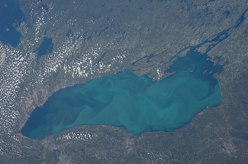
File:ISS-36_Lake_Ontario_(horizontal).jpg · Wikimedia Commons · See Wikimedia Commons
OverviewAI-generated
Lake Ontario is a body of water with a surface area of 18529 and a perimeter of 1146. It has a length of 311 and a width of 85. The lake sits at an elevation of 74.1 above sea level. Its vertical depth reaches 244, and it holds a volume of 1639000.
The watershed area associated with the lake is 690000. The residence time of the water is 6. The subject is referenced by 2,410 other encyclopedia articles.
Synthesized by Vinony from 11 facts across 2 sources: Wikidata, Vinony graph. Generated from structured data (not the Wikipedia text) and checked against those facts — may still contain errors.
Wikidata facts
- Instance of
- lake
- Part of
- Great Lakes
- Country
- United States
- Located in
- Ontario
- Area
- 18529
- Elevation
- 74.1
- Image
- ISS-36 Lake Ontario (horizontal).jpg
- Width
- 85
- Length
- 311
- Perimeter
- 1146
Show 10 more facts
- basin country
- Canada
- outflows
- St. Lawrence River
- topic's main category
- Category:Lake Ontario
- Commons category
- Lake Ontario
- watershed area
- 690000
- residence time of water
- 6
- vertical depth
- 244
- volume as quantity
- 1639000
- on focus list of Wikimedia project
- Wikipedia:Vital articles/Level/4
- native label
- Lake Ontario
Sources (7)
via Wikidata · CC0
~28 min read
Encyclopedic overview
Lake Ontario (French: Lac Ontario) is one of the five Great Lakes of North America. It is bounded on the north, west, and southwest by the Canadian province of Ontario, and on the south and east by the U.S. state of New York. The Canada–United States border spans the centre of the lake. On the Canadian side, the major cities are Kingston, Mississauga, Toronto, Hamilton, and St. Catharines. On the American side, the major cities are Rochester and Watertown.
The last in the Great Lakes chain, Lake Ontario serves as the outlet to the Atlantic Ocean via the Saint Lawrence River, comprising the western end of the Saint Lawrence Seaway. Its primary inlet is the Niagara River from Lake Erie. The Long Sault control dam, primarily along with the Moses-Saunders Power Dam regulates the water level of the lake.
Excerpted from Wikipedia’s “Lake Ontario” article, available under the CC BY-SA 4.0 licence.
Gallery (12)
On the map
Available in 104 languages
- Español
- Français
- Deutsch
- 中文
- 日本語
- Русский
- Português
- Italiano
- العربية
- हिन्दी
- Afrikaans
- Aramaic
- Armenian
- Asturian
- Azerbaijani
- Bahasa Indonesia
- Bashkir
- Basque
Show 85 more
- be_x_old
- Belarusian
- Bosnian
- Breton
- Bulgarian
- Catalan
- Cebuano
- Central Kurdish
- Chuvash
- Croatian
- Czech
- Danish
- Egyptian Arabic
- Esperanto
- Estonian
- Faroese
- Fiji Hindi
- Finnish
- fiu_vro
- Galician
- Georgian
- Greek
- Hebrew
- Hungarian
- Icelandic
- Interlingua
- Irish
- Javanese
- Kabyle
- Kazakh
- Kurdish
- Kyrgyz
- Latin
- Latvian
- Limburgish
- Lithuanian
- Luxembourgish
- Macedonian
- Maithili
- Malagasy
- Malay
- Malayalam
- Marathi
- Mazanderani
- Mingrelian
- Mongolian
- Nederlands
- Nepali
- Newari
- Norwegian
- Norwegian Nynorsk
- Occitan
- Ossetic
- Piedmontese
- Polski
- Punjabi
- Quechua
- Romanian
- Rusyn
- Scots
- Scottish Gaelic
- Serbian
- Serbian (Latin)
- Sicilian
- simple
- Slovak
- Slovenian
- Svenska
- Swahili
- Tamil
- Telugu
- Tiếng Việt
- Türkçe
- Ukrainian
- Urdu
- Uzbek
- Waray
- Welsh
- Western Frisian
- Western Panjabi
- Wu Chinese
- zh_yue
- فارسی
- ไทย
- 한국어
via Wikidata sitelinks · CC0