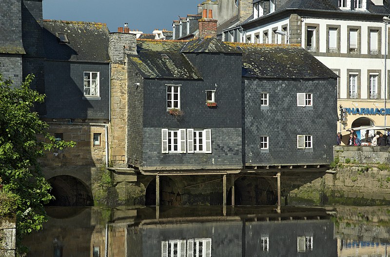
File:Pont_de_rohan_20060523-002.jpg · Wikimedia Commons · See Wikimedia Commons
OverviewAI-generated
Landerneau is a commune in the Finistère department of France, situated within the arrondissement of Brest and the Communauté d'agglomération du Pays de Landerneau-Daoulas. It serves as the capital of the canton of Landerneau. The town is located next to the Élorn river and shares borders with Ploudaniel, Dirinon, Loperhet, and La Forest-Landerneau. Its postal code is 29800, and it lies in the Europe/Paris timezone.
The area of Landerneau is 13.19 square kilometers. Population figures vary by source, with one listing 16,468 residents (7,429 male and 8,352 female) and another citing 16,052. The elevation is recorded as either 10 or 15 meters. The demonym for residents is Landernéens or Landernéennes. Landerneau is twinned with Hünfeld, Mioveni, and Kongoussi.
Synthesized by Vinony from 53 facts across 7 sources: Wikidata, Open Meteo, Openweathermap, OpenStreetMap, GeoNames, Vinony graph, Geo. Generated from structured data (not the Wikipedia text) and checked against those facts — may still contain errors.
Weather now
7-day forecast
via Open-Meteo
Place details
- Locality
- Landerneau
- Region
- Bretagne
- Country
- France
- Population
- 16,052
- Timezone
- Europe/Paris
via OpenStreetMap · GeoNames
Key facts
- French commune.name
- Landerneau
- French commune.commune status
- Commune
- French commune.image
- Pont de rohan 20060523-002.jpg
- French commune.caption
- Houses with a slate facade, on the Rohan Bridge
- French commune.image flag
- Flag of Landerneau.svg
- French commune.image coat of arms
- Blason ville fr Landerneau (Finistère).svg
- French commune.INSEE
- 29103
- French commune.postal code
- 29800
- French commune.arrondissement
- Brest
- French commune.canton
- Landerneau
- French commune.mayor
- Patrick Leclerc
- French commune.term
- 2020–2026
- French commune.intercommunality
- CA Pays de Landerneau-Daoulas
- French commune.elevation min m
- 1
- French commune.elevation max m
- 175
- French commune.area km2
- 13.19
via Wikipedia infobox
Wikidata facts
- Instance of
- commune of France
- Official name
- Landerneau
- Demonym
- Landernéennes
- Country
- France
- Located in
- arrondissement of Brest
- Population
- 16363
- Area
- 13.19
- Elevation
- 61
- Time zone
- UTC+02:00
- Body of water
- Élorn
- Shares border with
- Saint-Thonan
- Official website
- www.landerneau.bzh
- Image
- Pont de rohan 20060523-002.jpg
Show 12 more facts
- topic's main category
- Category:Landerneau
- twinned administrative body
- Kongoussi
- Commons category
- Landerneau
- postal code
- 29800
- Commons gallery
- Landerneau
- category of associated people
- Category:People from Landerneau
- associated electoral district
- canton of Landerneau
- male population
- 7429
- female population
- 8352
- contact page URL
- www.landerneau.bzh/systeme/nous-contacter
- phone number
- +33-2-98-85-43-00
- P12749
- Heinz-Harald Frentzen
via Wikidata · CC0
Article · 中文
朗代诺(法語:Landerneau,法语发音:[lɑ̃dɛʁno],布列塔尼語:Landerne,布列塔尼语发音:[lãnˈdɛrne],一译朗代尔诺),法国西北部城市,布列塔尼大区菲尼斯泰尔省的一个市镇,隶属于布雷斯特区,其市镇面积为13.19平方公里,2019年1月1日时人口数量为15,918人,是该省人口第四多的市镇,在法国城市中排名第600位。 朗代诺位于菲尼斯泰尔省北部,布列塔尼半岛西部的一处溺湾的顶端,埃洛恩河在此注入大西洋。朗代诺是一个区域性的中心城市和交通枢纽,三个方向的铁路在此交汇。
Abstract from DBpedia / Wikipedia · CC BY-SA
Gallery (3)
On the map
2 mapped locations