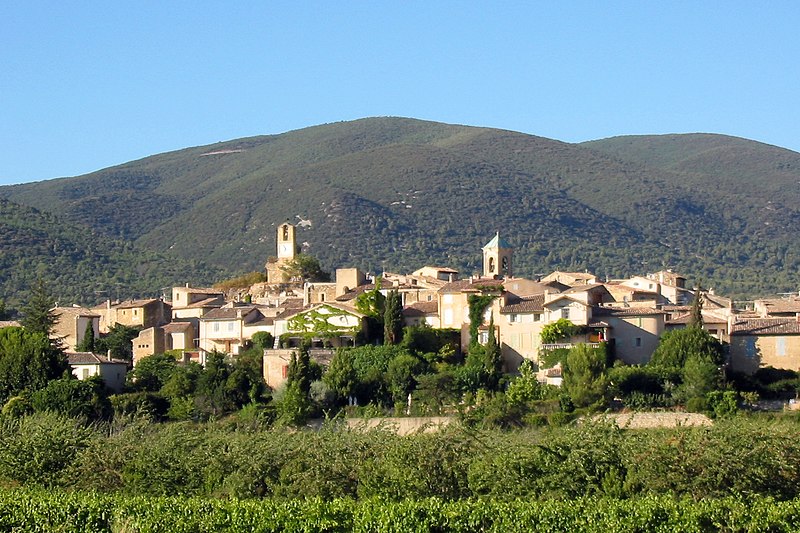
File:Lourmarin.jpg · Wikimedia Commons · See Wikimedia Commons
Lourmarin
Sign in to saveAlso known as Lormarin
Lourmarin (; ) is a commune in the Vaucluse department in the Provence-Alpes-Côte d'Azur region in southeastern France. Its inhabitants are called Lourmarinois.
OverviewAI-generated
Lourmarin is a commune in France, situated within the Vaucluse department and the arrondissement of Apt. It lies in the Provence-Alpes-Côte d'Azur region and is part of the Canton of Cadenet, with an associated electoral district in the canton of Cheval-Blanc. The town borders Bonnieux, Buoux, Cadenet, and Puyvert. Its postal code is 84160, and it is a member of The Most Beautiful Villages of France.
The commune covers an area of 20.18 square kilometers. Population figures vary by source, with one listing 1,142 residents (485 male and 591 female) and another citing 1,188. Elevation data also differs, with one source recording 818 meters and another 218 meters above sea level. Lourmarin is twinned with Żyrardów.
Synthesized by Vinony from 49 facts across 8 sources: Wikidata, Open Meteo, Openweathermap, OpenStreetMap, GeoNames, Firecrawl, Vinony graph, Geo. Generated from structured data (not the Wikipedia text) and checked against those facts — may still contain errors.
Weather now
7-day forecast
via Open-Meteo
Place details
- Locality
- Lourmarin
- Region
- Provence-Alpes-Côte d'Azur
- Country
- France
- Population
- 1,188
- Timezone
- Europe/Paris
via OpenStreetMap · GeoNames
Key facts
- French commune.name
- Lourmarin
- French commune.commune status
- Commune
- French commune.image
- Lourmarin.jpg
- French commune.caption
- View of Lourmarin with vineyards and orchards
- French commune.image coat of arms
- Blason ville fr Lourmarin (Vaucluse).svg
- French commune.arrondissement
- Apt
- French commune.canton
- Cheval-Blanc
- French commune.INSEE
- 84068
- French commune.postal code
- 84160
- French commune.mayor
- Jean-Pierre Pettavino
- French commune.term
- 2020–2026
- French commune.intercommunality
- CA Luberon Monts de Vaucluse
- French commune.elevation m
- 200
- French commune.elevation min m
- 169
- French commune.elevation max m
- 818
- French commune.area km2
- 20.18
via Wikipedia infobox
Official website
Site de la Mairie de Lourmarin - Lourmarin.com -
Lourmarin, situé dans le parc naturel régional du Luberon, est un des plus beaux villages de France. Venez ou revenez le découvrir !
lourmarin.com →Link to the official site · 5,968 chars · not written by Vinony
Wikidata facts
- Instance of
- commune of France
- Official name
- Lourmarin
- Country
- France
- Located in
- arrondissement of Apt
- Population
- 1020
- Area
- 20.18
- Elevation
- 360
- Time zone
- UTC+02:00
- Shares border with
- Vaugines
- Official website
- www.lourmarin.com
- Image
- Lourmarin.jpg
Show 10 more facts
- Commons category
- Lourmarin
- postal code
- 84160
- twinned administrative body
- Żyrardów
- associated electoral district
- canton of Cheval-Blanc
- male population
- 485
- female population
- 591
- email address
- mailto:[email protected]
- phone number
- +33-4-90-68-04-13
- fax number
- +33-4-90-68-26-46
Sources (7)
via Wikidata · CC0
Travel guide
See
thumb Extremely picturesque, the village is a magnet for tourists. Prominent sites are the village itself, the pretty Renaissance castle, the Catholic and Protestant churches and the view from the village of the Proches Bastides, a large fortified farmhouse dating to the Middle Ages. thumb|Tomb of Albert Camus The cemetery is home to two personalities of French literature: thumb|Église Saint-André The heritage of the town is quite substantial, both religious and civil. Part of this heritage is protected as historical monuments.
Travel guide from Wikivoyage (CC BY-SA 4.0)
~3 min read
Encyclopedic overview
9 sectionsContents
- Geography
- History
- Sights
- Miscellaneous
- Twin towns – Sister cities
- Gallery
- See also
- References
- External links
Lourmarin (; ) is a commune in the Vaucluse department in the Provence-Alpes-Côte d'Azur region in southeastern France. Its inhabitants are called Lourmarinois.
==Geography== Lourmarin is located in the French region of Provence, at the foot of the Luberon Massif where a southern pass debouches over the Luberon from Apt on the northern side of the Luberon. The pass divides the Grand Luberon from the Petit Luberon range, an area rich in Neolithic remains and noted for its dramatic massifs and rockscapes. The Aigues Brun brook comes out of the pass and runs just to the west of the village (Aigue is a Provençal language word for "water", coming from Latin aqua).
Excerpted from Wikipedia’s “Lourmarin” article, available under the CC BY-SA 4.0 licence.
Gallery (7)
On the map
2 mapped locations