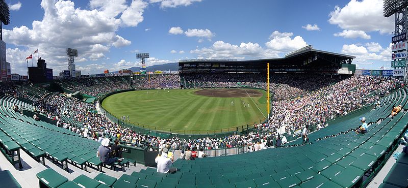
File:Hanshin_Koshien_Stadium_2009.jpg · Wikimedia Commons · See Wikimedia Commons
Nishinomiya
Sign in to saveAlso known as Nishinomiya City, Nishinomiya-shi
thumb|right|270px|Nishinomiya City Hall thumb|right|270px|Aerial view of Nishinomiya city center 1985 thumb|right|270px|Hirota Shrine is a city located in Hyōgo Prefecture, Japan. , the city had an estimated population of 484,368 in 218,948 households and a population density of 4,800 persons per km². The total area of the city is . Nishinomiya is an important commercial and shipping city in the Kansai region with the third largest population in Hyōgo Prefecture. Nishinomiya is best known as the home of Koshien Stadium, where the Hanshin Tigers baseball team plays home games and where Japan's
Nishinomiya is a city in Hyōgo Prefecture, Japan, with a population of around 484,000 and serves as an important commercial and shipping hub in the Kansai region. It is best known as the home of Koshien Stadium, where the Hanshin Tigers baseball team plays.
AI-generated from the Wikipedia summary — may contain errors.
Key facts
- Settlement.name
- Nishinomiya
- Settlement.native_name_lang
- ja
- Settlement.settlement_type
- Core city
- Settlement.image_caption
- From top left: Hanshin Koshien Stadium, Nishinomiya Shrine, Tōkō-ji, Shukugawa Park, and Hankyu Nishinomiya Gardens
- Settlement.image_flag
- Flag of Nishinomiya, Hyogo.svg
- Settlement.image_seal
- Emblem of Nishinomiya, Hyogo.svg
- Settlement.seal_type
- Chapter
- Settlement.map_caption
- Location of Nishinomiya in Hyōgo Prefecture
- Settlement.image_map1
- Nishinomiya in Hyogo Prefecture Ja.svg
- Settlement.pushpin_map
- Japan
- Settlement.pushpin_map_caption
- Location in Japan
- Settlement.subdivision_type
- Country
- Settlement.subdivision_name
- Japan
- Settlement.subdivision_type1
- Region
- Settlement.subdivision_name1
- Kansai
- Settlement.subdivision_type2
- Prefecture
- Settlement.subdivision_name2
- Hyōgo
- Settlement.subdivision_type3
- District
via Wikipedia infobox
Wikidata facts
- Instance of
- big city
- Named after
- Hirota Shrine
- Official name
- 西宮市
- Country
- Japan
- Population
- 426909
- Area
- 99.96
- Time zone
- UTC+09:00
- Body of water
- Muko River
- Shares border with
- Kobe
- Official website
- www.nishi.or.jp/multilingual
- Image
- Shukugawa Park in spring.jpg
Show 12 more facts
- inception
- 1200-00-00
- twinned administrative body
- Londrina
- Commons category
- Nishinomiya
- category for people born here
- Category:Births in Nishinomiya, Hyogo
- topic's main category
- Category:Nishinomiya
- postal code
- 662-8567
- native label
- 西宮市
- category of associated people
- Category:People from Nishinomiya
- social media followers
- 7560
- official symbol
- Cinnamomum camphora
- located in/on physical feature
- Osaka Plain
- name in kana
- にしのみやし
Sources (10)
via Wikidata · CC0
~8 min read
Encyclopedic overview
22 sectionsContents
- Geography
- Neighboring municipalities
- Climate
- Demographics
- History
- Government
- Economy
- Agriculture
- Residential districts
- Education
- Universities and colleges
- Primary and secondary schools
- Transportation
- Railways
- Highways
- International relations
- Local attractions
- In popular culture
- Notable people from Nishinomiya
- Gallery
- References
- External links
thumb|right|270px|Nishinomiya City Hall thumb|right|270px|Aerial view of Nishinomiya city center 1985 thumb|right|270px|Hirota Shrine is a city located in Hyōgo Prefecture, Japan. , the city had an estimated population of 484,368 in 218,948 households and a population density of 4,800 persons per km². The total area of the city is . Nishinomiya is an important commercial and shipping city in the Kansai region with the third largest population in Hyōgo Prefecture. Nishinomiya is best known as the home of Koshien Stadium, where the Hanshin Tigers baseball team plays home games and where Japan's annual high school baseball championship is held.
== Geography == Nishinomiya is located in southeast Hyōgo Prefecture between the cities of Kobe and Osaka. It is bordered by Osaka Bay to the south, the cities of Amagasaki, Itami and Takarazuka along the Mukogawa and Nigawa rivers to the east and by the Rokkō Mountains and Kobe to the north. The city can be divided into two areas: a mountainous area in the north and a coastal plain in the south. Situated in the middle is Mount Kabuto (309 meters), a landmark of the city.
Excerpted from Wikipedia’s “Nishinomiya” article, available under the CC BY-SA 4.0 licence.
Gallery (30)
On the map
3 mapped locations
Available in 57 languages
- Español
- Français
- Deutsch
- 中文
- 日本語
- Русский
- Português
- Italiano
- العربية
- azb
- Azerbaijani
- Bahasa Indonesia
- Basque
- Belarusian
- Bulgarian
- Catalan
- Cebuano
- Central Kurdish
Show 38 more
via Wikidata sitelinks · CC0