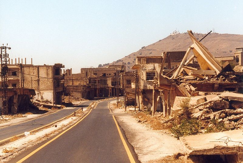
File:Qunaitra.jpg · Wikimedia Commons · See Wikimedia Commons
Quneitra
Sign in to saveAlso known as Qunaitira
Quneitra (also Al Qunaytirah, Qunaitira, or Kuneitra; or , ) is the largely destroyed and abandoned capital of the Quneitra Governorate in south-western Syria. It is situated in a high valley in the Golan Heights at 1,010 metres (3,313 feet) above sea level. Since 1974, pursuant to United Nations Security Council Resolution 350 and the Agreement on Disengagement between Israel and Syria, the city is inside the UN-patrolled buffer zone.
OverviewAI-generated
Quneitra is a city in Syria, situated within the Golan Heights and the Quneitra sub-district. It serves as the capital of the Quneitra Governorate. The city is located at an elevation of 942 meters above sea level and falls within the Asia/Damascus time zone. Its official name is القنيطرة, and it is distinct from Al-Qunaitira.
The population of Quneitra is recorded as 153 in one dataset and 36,143 in another. The local dialing code is 43. According to OpenStreetMap data, the site is classified as ruins. The city has an official website and is referenced by 345 other encyclopedia articles.
Synthesized by Vinony from 44 facts across 7 sources: Wikidata, Open Meteo, Openweathermap, OpenStreetMap, GeoNames, Vinony graph, Geo. Generated from structured data (not the Wikipedia text) and checked against those facts — may still contain errors.
Weather now
7-day forecast
via Open-Meteo
Place details
- Locality
- القنيطرة
- Region
- محافظة القنيطرة
- Country
- سوريا
- Population
- 36,143
- Timezone
- Asia/Damascus
via OpenStreetMap · GeoNames
Key facts
- Settlement.name
- Quneitra
- Settlement.image_skyline
- Qunaitra.jpg
- Settlement.image_caption
- View of the destroyed city
- Settlement.pushpin_map
- Syria#Syria Golan
- Settlement.pushpin_label_position
- bottom
- Settlement.pushpin_relief
- yes
- Settlement.pushpin_map_caption
- Location of Quneitra within Syria##Location of Quneitra within Golan Heights, Syria
- Settlement.subdivision_type
- Country
- Settlement.subdivision_type1
- Governorate
- Settlement.subdivision_name1
- Quneitra
- Settlement.subdivision_type2
- District
- Settlement.subdivision_name2
- Quneitra
- Settlement.subdivision_type3
- Subdistrict
- Settlement.subdivision_name3
- Quneitra
- Settlement.subdivision_type4
- Region
- Settlement.subdivision_name4
- Golan HeightsUNDOF Zone
- Settlement.subdivision_type5
- Control
- Settlement.subdivision_name5
- (since 2024-present)
via Wikipedia infobox
Wikidata facts
- Official name
- القنيطرة
- Country
- Syria
- Located in
- Quneitra sub-district
- Population
- 153
- Elevation
- 942
- Capital of
- Quneitra Governorate
- Official website
- www.equnaytra.sy
- Image
- Qunaitra.jpg
- Dialing code
- 43
Show 3 more facts
- Commons category
- Quneitra
- inception
- 1000-00-00
- different from
- Al-Qunaitira
via Wikidata · CC0
Travel guide
Understand
The de facto Israel-Syria border runs through the Golan Heights along an area known as the Purple Line. This line was patrolled by a United Nations peacekeeping force until 2015, but the peacekeepers were attacked by the Syrian opposition and all of them have been withdrawn from Syria, removing a stabilizing element from the border.
Get in
Travel from Israel is difficult. Travel from Syria would be the logical entry point, if the situation in Syria were not so volatile.
Get around
Stay on the main paths only. The area is heavily landmined.
See
thumb|Street scene in Quneitra.
Stay safe
thumb|240px|Mine warning sign in the Israeli-controlled part of the Golan Because of the 2011-2024 civil war, many governments recommend against all travel to Syria. See the Syria article for more information.
A large part of the Golan Heights area is either heavily mined, or is suspected as being mined - this is because old mines may drift during heavy rains, which are frequent in winter. You should never walk or drive in open fields, off main roads or dirt roads (unless there are very clear signs which indicate that this area is safe, such as trail signs). While most mine fields are designated by warning signs (as the one shown in the picture), do not go into off-road barb-wired fields, even if they are not marked with signs (in short, never cross any fence unless there are clear signs and/or suitable gateways in the fence). Never touch unidentified metal or plastic debris in the open even if it looks harmless.
Go next
In safer times, Damascus would've been the logical next stop. Travel to Israel was and is far more difficult.
Travel guide from Wikivoyage (CC BY-SA 4.0)
~23 min read
Encyclopedic overview
22 sectionsContents
- Etymology
- Political status
- Geography and demographics
- Climate
- History
- Prehistory
- Hellenistic to Byzantine periods
- Late Ottoman period
- Second World War
- Arab-Israeli conflict
- Six-Day War
- Israeli occupation
- Yom Kippur War
- Destruction of Quneitra and return to Syrian control
- As a city ruin
- Civil war
- 2024 Israeli invasion of Syria
- Religious buildings
- See also
- References
- Further reading
- External links
Quneitra (also Al Qunaytirah, Qunaitira, or Kuneitra; or , ) is the largely destroyed and abandoned capital of the Quneitra Governorate in south-western Syria. It is situated in a high valley in the Golan Heights at 1,010 metres (3,313 feet) above sea level. Since 1974, pursuant to United Nations Security Council Resolution 350 and the Agreement on Disengagement between Israel and Syria, the city is inside the UN-patrolled buffer zone.
Quneitra was founded in the Ottoman era as a way station on the caravan route to Damascus and subsequently became a garrison town of some 20,000 people. In 1946, it became part of the independent Syrian Republic within the Riff Dimashq Governorate and in 1964 became the capital of the split Quneitra Governorate. On 10 June 1967, the last day of the Six-Day War, Quneitra came under Israeli control. It was briefly recaptured by Syria during the 1973 Yom Kippur War, but Israel regained control in its subsequent counter-offensive. The city was almost completely destroyed by Israel before it withdrew in June 1974. Syria later refused to rebuild the city and actively discouraged resettlement in the area. Israel was heavily criticized by the United Nations for the city's destruction, while Israel has also criticized Syria for not rebuilding Quneitra.
Excerpted from Wikipedia’s “Quneitra” article, available under the CC BY-SA 4.0 licence.
Gallery (31)
On the map
6 mapped locations