File:Saint-Guilhem-le-Desert_fg02.jpg · Wikimedia Commons · See Wikimedia Commons
Saint-Guilhem-le-Désert
Sign in to saveAlso known as Verdus-le-Désert
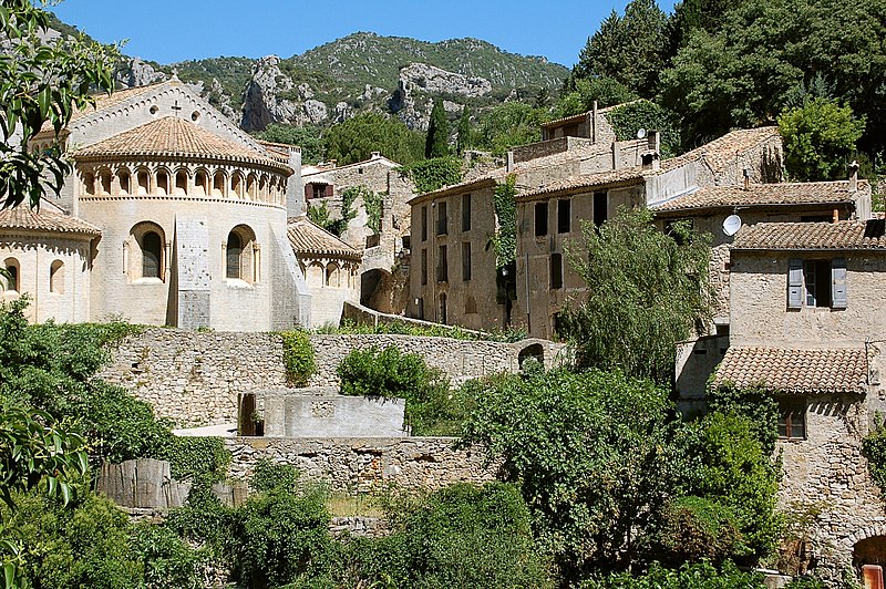
Saint-Guilhem-le-Désert ( or ; ) is a commune in the Hérault department in the Occitania region in Southern France. Situated where the Gellone river's narrow valley meets the steep-sided gorge of the river Hérault, Saint-Guilhem-le-Désert is essentially a medieval village located on the Chemin de Saint-Jacques (Way of St James) pilgrim route to Santiago de Compostela.
OverviewAI-generated
Saint-Guilhem-le-Désert is a commune in France, situated in the Hérault department within the Occitanie region. It has at various times been part of the arrondissement of Lodève and the arrondissement of Montpellier, and it is associated with the canton of Gignac. The commune shares borders with Aniane, Causse-de-la-Selle, Montpeyroux, and Pégairolles-de-Buèges. Its official name is also listed as Verdus-le-Désert, and the local demonym is Saute-Rocs or Saute-Rochers.
The area covers 38.64 square kilometers, with an elevation of 812 meters above sea level. Population figures vary between sources, with one listing 274 residents (123 male and 130 female) and another citing 241. The postal code is 34150. Saint-Guilhem-le-Désert holds the heritage designation of Grand site de France and is a member of The Most Beautiful Villages of France.
Synthesized by Vinony from 38 facts across 6 sources: Wikidata, Openweathermap, OpenStreetMap, GeoNames, Vinony graph, Geo. Generated from structured data (not the Wikipedia text) and checked against those facts — may still contain errors.
Weather now
7-day forecast
via Open-Meteo
Place details
- Locality
- Saint-Guilhem-le-Désert
- Region
- Occitanie
- Country
- France
- Population
- 241
via OpenStreetMap · GeoNames
Key facts
- French commune.name
- Saint-Guilhem-le-Désert
- French commune.commune status
- Commune
- French commune.image
- Saint-Guilhem-le-Desert fg02.jpg
- French commune.caption
- Saint-Guilhem-le-Désert Abbey
- French commune.image coat of arms
- Blason ville fr Saint-Guilhem-le-Désert (Hérault).svg
- French commune.arrondissement
- Lodève
- French commune.canton
- Gignac
- French commune.INSEE
- 34261
- French commune.postal code
- 34150
- French commune.mayor
- Robert Siegel
- French commune.term
- 2020–2026
- French commune.elevation m
- 89
- French commune.elevation min m
- 54
- French commune.elevation max m
- 812
- French commune.area km2
- 38.64
via Wikipedia infobox
Wikidata facts
- Instance of
- commune of France
- Official name
- Verdus-le-Désert
- Demonym
- Saute-Rocs ; Saute-Rochers
- Country
- France
- Population
- 237
- Area
- 38.64
- Elevation
- 415
- Time zone
- UTC+02:00
- Shares border with
- Montpeyroux
- Official website
- www.saint-guilhem-le-desert.com
- Image
- Saint-Guilhem-le-Désert.jpg
Show 11 more facts
- Commons category
- Saint-Guilhem-le-Désert
- postal code
- 34150
- heritage designation
- Grand site de France
- Commons gallery
- Saint-Guilhem-le-Désert
- associated electoral district
- canton of Gignac
- male population
- 123
- female population
- 130
- P8168
- Emiliano González
- email address
- mailto:[email protected]
- phone number
- +33-4-67-57-70-17
Sources (7)
via Wikidata · CC0
Travel guide
Get around
The entire town is walking streets. If you bring a car you need to leave it in one of the three car parks outside of the town and walk in (about five minutes max).
Nearby there is a famous bridge called the Pont du Diable, there is a free bus that goes to it from Saint Guilhem. You can catch it from the car park at the bottom of the town.
Do
thumb|The Pont du Diable There are several walking trails in the hills around the town. They're clearly marked and give good views of the town.
Not far away is the Pont du Diable which is a good place to swim, kayak down the river or relax on the stony beach.
Travel guide from Wikivoyage (CC BY-SA 4.0)
~6 min read
Encyclopedic overview
11 sectionsContents
- Geography
- Hydrography
- History
- Landmarks
- Culture
- Demographics
- Miscellaneous
- Gallery
- See also
- References
- External links
Saint-Guilhem-le-Désert ( or ; ) is a commune in the Hérault department in the Occitania region in Southern France. Situated where the Gellone river's narrow valley meets the steep-sided gorge of the river Hérault, Saint-Guilhem-le-Désert is essentially a medieval village located on the Chemin de Saint-Jacques (Way of St James) pilgrim route to Santiago de Compostela.
==Geography== The municipality of Saint-Guilhem covers nearly 40km² in area. The town is served by two departmental roads - the D122 and D4. The nearest towns are Saint-André-de-Sangonis (12 km away) and Gignac (15 km away). Montpellier, Lodève and Ganges (which stands near the source of the Hérault) are all about 35 km away.
Excerpted from Wikipedia’s “Saint-Guilhem-le-Désert” article, available under the CC BY-SA 4.0 licence.
Gallery (13)
On the map
2 mapped locations