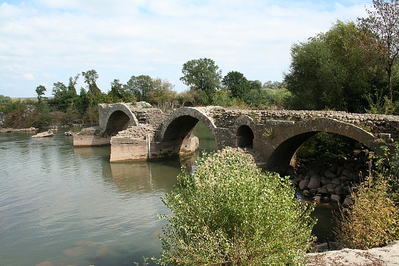
File:St-Thibery-Pont-Romain1.JPG · Wikimedia Commons · See Wikimedia Commons
Saint-Thibéry
Sign in to saveSaint-Thibéry (; ) is a commune in the Hérault département in the Occitanie region in southern France.
OverviewAI-generated
Saint-Thibéry is a commune in France, situated within the Hérault department and the arrondissement of Béziers. It is part of the Communauté d'agglomération Hérault Méditerranée and the canton of Pézenas. The municipality borders Bessan, Florensac, Montblanc, and Nézignan-l'Évêque, and is located next to the Hérault body of water. Its official postal code is 34630.
The area of Saint-Thibéry is 18.47, with an elevation above sea level of 80. The population is recorded as 3132, comprising 1273 males and 1392 females. The residents are known as Saint-Thibériens. The commune is described in the Pauly–Wissowa source.
Synthesized by Vinony from 42 facts across 6 sources: Wikidata, Openweathermap, OpenStreetMap, GeoNames, Vinony graph, Geo. Generated from structured data (not the Wikipedia text) and checked against those facts — may still contain errors.
Weather now
7-day forecast
via Open-Meteo
Place details
- Locality
- Saint-Thibéry
- Region
- Occitanie
- Country
- France
- Population
- 2,481
- Timezone
- Europe/Paris
via OpenStreetMap · GeoNames
Key facts
- French commune.name
- Saint-Thibéry
- French commune.commune status
- Commune
- French commune.image
- St-Thibery-Pont-Romain1.JPG
- French commune.caption
- Roman Bridge, actually medieval
- French commune.image coat of arms
- Blason ville fr Saint-Thibéry (Hérault).svg
- French commune.arrondissement
- Béziers
- French commune.canton
- Pézenas
- French commune.INSEE
- 34289
- French commune.postal code
- 34630
- French commune.mayor
- Jean Augé
- French commune.term
- 2020–2026
- French commune.intercommunality
- CA Hérault Méditerranée
- French commune.elevation m
- 19
- French commune.elevation min m
- 0
- French commune.elevation max m
- 80
- French commune.area km2
- 18.47
via Wikipedia infobox
Wikidata facts
- Instance of
- commune of France
- Official name
- Saint-Thibéry
- Demonym
- Saint-Thibériens
- Country
- France
- Population
- 3132
- Area
- 18.47
- Elevation
- 24
- Time zone
- UTC+01:00
- Shares border with
- Valros
- Official website
- ville-saint-thibery.fr
- Image
- St-Thibery Mairie.JPG
Show 11 more facts
- postal code
- 34630
- Commons category
- Saint-Thibéry
- Commons gallery
- Saint-Thibéry
- described by source
- Pauly–Wissowa
- associated electoral district
- canton of Pézenas
- male population
- 1273
- female population
- 1392
- P8168
- psychedelic frogfish
- email address
- mailto:[email protected]
- phone number
- +33-4-67-77-80-57
- fax number
- +33-4-67-77-06-60
Sources (7)
via Wikidata · CC0
~3 min read
Encyclopedic overview
7 sectionsContents
- Saint-Thibéry Abbey and Church
- Saint-Thibéry mill
- Volcano
- Saint-Thibéry rivers
- Population
- See also
- References
Saint-Thibéry (; ) is a commune in the Hérault département in the Occitanie region in southern France.
The village of Saint-Thibéry is built at the confluence of the Rivers Thongue and Hérault. The old Roman road "Via Domitia" runs through the village (Grand Rue) and some of the houses date back to the 15th century.
Excerpted from Wikipedia’s “Saint-Thibéry” article, available under the CC BY-SA 4.0 licence.
Gallery (12)
On the map
2 mapped locations