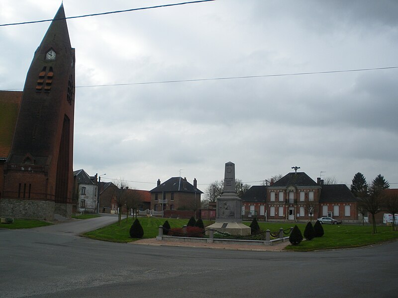
File:Sauchy-Lestrée_-_Place_principale.JPG · Wikimedia Commons · See Wikimedia Commons
Sauchy-Lestrée
Sign in to saveSauchy-Lestrée is a commune in the Pas-de-Calais department in the Hauts-de-France region of France.
OverviewAI-generated
Sauchy-Lestrée is a commune in the Pas-de-Calais department of France, situated within the arrondissement of Arras and the canton of Marquion. It shares borders with Oisy-le-Verger, Haynecourt, Épinoy, and Marquion. The municipality has an area of 9.06 square kilometers and an elevation of 77 meters above sea level. Its postal code is 62860, and it falls under the associated electoral district of the canton of Bapaume.
The population of Sauchy-Lestrée is 466, comprising 224 males and 231 females. The commune received the Croix de guerre 1914–1918. One of its streets, Rue du Tréfond, is classified as a tertiary road. The local government can be contacted via the phone number +33-3-21-59-60-72 or by email at [email protected].
Synthesized by Vinony from 47 facts across 7 sources: Wikidata, Open Meteo, Openweathermap, OpenStreetMap, GeoNames, Vinony graph, Geo. Generated from structured data (not the Wikipedia text) and checked against those facts — may still contain errors.
In the Vinony graph
The entry is geolocated on the map, across 2 mapped points.
Within Vinony's link graph, Sauchy-Lestrée is referenced by 895 other articles, and connects out to France, World War I and time zone.
It is catalogued under the topic Communes of the Pas-de-Calais.
Its subject is documented across 43 Wikipedia language editions.
Weather now
cached 12h ago7-day forecast
via Open-Meteo
Place details
- Locality
- Sauchy-Lestrée
- Region
- Hauts-de-France
- Country
- France
- Population
- 456
via OpenStreetMap · GeoNames
Key facts
- French commune.name
- Sauchy-Lestrée
- French commune.commune status
- Commune
- French commune.image
- Sauchy-Lestrée - Place principale.JPG
- French commune.caption
- The main square of Sauchy-Lestrée
- French commune.image coat of arms
- Blason Sauchy-Lestrée.svg
- French commune.arrondissement
- Arras
- French commune.canton
- Bapaume
- French commune.INSEE
- 62781
- French commune.postal code
- 62860
- French commune.mayor
- Francis Rigaut
- French commune.term
- 2020–2026
- French commune.intercommunality
- CC Osartis Marquion
- French commune.elevation m
- 47
- French commune.elevation min m
- 41
- French commune.elevation max m
- 77
- French commune.area km2
- 9.06
via Wikipedia infobox
Wikidata facts
- Instance of
- commune of France
- Official name
- Sauchy-Lestrée
- Country
- France
- Located in
- canton of Marquion
- Population
- 438
- Area
- 9.06
- Elevation
- 62
- Shares border with
- Sauchy-Cauchy
- Image
- Sauchy-Lestrée - Place principale.JPG
Show 9 more facts
- Commons category
- Sauchy-Lestrée
- postal code
- 62860
- associated electoral district
- canton of Bapaume
- male population
- 224
- female population
- 231
- P8168
- Abax
- email address
- mailto:[email protected]
- phone number
- +33-3-21-59-60-72
- fax number
- +33-3-21-59-31-96
Sources (4)
via Wikidata · CC0
~1 min read
Encyclopedic overview
6 sectionsContents
- Geography
- Population
- Places of interest
- See also
- References
- External links
Sauchy-Lestrée is a commune in the Pas-de-Calais department in the Hauts-de-France region of France.
==Geography== Sauchy-Lestrée lies southeast of Arras, at the junction of the D21E and D15 roads.
Excerpted from Wikipedia’s “Sauchy-Lestrée” article, available under the CC BY-SA 4.0 licence.
Gallery (2)
On the map
2 mapped locations