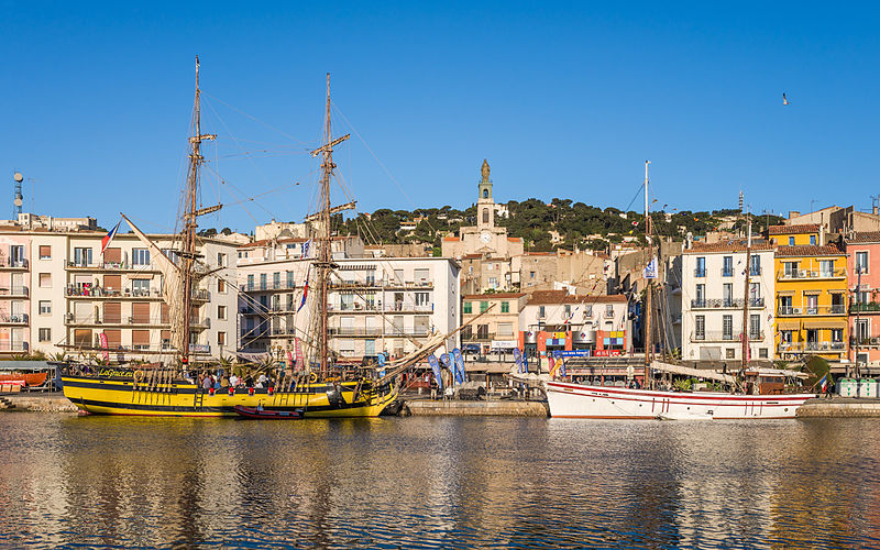
File:La_Grace_(ship,_2010),_Sète,_Hérault_01.jpg · Wikimedia Commons · See Wikimedia Commons
Sète
Sign in to saveAlso known as Seta
Sète (; , ), also historically spelled Cette (official until 1928) and Sette, is a resort town and commune in the Hérault department, in the region of Occitania, southern France. Its inhabitants are called Sétois (male) and Sétoises (female) in French, "Setòris" and "Setòria" in Occitan.
OverviewAI-generated
Sète is a commune in France, situated in the Hérault department within the Occitanie region. It serves as the capital of the cantons of Sète-1 and Sète-2, as well as the broader canton of Sète. The town is located in the arrondissement of Montpellier and shares borders with Frontignan, Bouzigues, Loupian, and Marseillan. Its official names are Sète and Cette, and it has the postal code 34200.
The municipality covers an area of 24.21 square kilometers. Population figures vary by source, with one listing 45,337 residents and another citing 40,736. Demographic data indicates a male population of 20,161 and a female population of 23,068. Sète is twinned with Neuburg an der Donau, El Jadida, Cetara, and Hartlepool. The town’s elevation is recorded as 176 meters in one dataset and 5 meters in another.
Synthesized by Vinony from 53 facts across 7 sources: Wikidata, Open Meteo, Openweathermap, OpenStreetMap, GeoNames, Vinony graph, Geo. Generated from structured data (not the Wikipedia text) and checked against those facts — may still contain errors.
Weather now
cached 232h ago7-day forecast
via Open-Meteo
Place details
- Locality
- Sète
- Region
- Occitanie
- Country
- France
- Population
- 40,736
- Timezone
- Europe/Paris
via OpenStreetMap · GeoNames
Key facts
- French commune.name
- Sète
- French commune.commune status
- Commune
- French commune.caption
- Clockwise from top: The Royal Canal, the Mont Saint-Clair lighthouse, the Sète naval cemetery, and the Molière theatre.
- French commune.image coat of arms
- Blason ville fr Sète (Hérault).svg
- French commune.arrondissement
- Montpellier
- French commune.canton
- Sète
- French commune.INSEE
- 34301
- French commune.postal code
- 34200
- French commune.demonym
- Sétois
- French commune.mayor
- Hervé Marquès
- French commune.party
- DVD
- French commune.term
- 2025–2026
- French commune.intercommunality
- CA Sète Agglopôle Méditerranée
- French commune.elevation m
- 4
- French commune.elevation min m
- 0
- French commune.elevation max m
- 176
- French commune.area km2
- 24.21
via Wikipedia infobox
Travel guide
Get around
Walking is the obvious choice within the city centre.
For slightly longer trips, Thau Agglo Transport offers public transport, with departures at least every 20 minutes during daytime on both weekdays and weekends. However, evening and night services are limited. A free circulator bus within the inner city, route 6, is available too.
See
thumb|Phare du Mont-Saint-Clair
Go next
The ferry to Morocco leaves a few times a week, and costs around €120.
Travel guide from Wikivoyage (CC BY-SA 4.0)
~9 min read
Encyclopedic overview
17 sectionsContents
- Geography
- Climate
- History
- 1600–1900
- 19th century
- 20th century
- 21st century
- Population
- Patron saint
- Transport
- Culture
- Notable people
- International relations
- Gallery
- See also
- References
- External links
Sète (; , ), also historically spelled Cette (official until 1928) and Sette, is a resort town and commune in the Hérault department, in the region of Occitania, southern France. Its inhabitants are called Sétois (male) and Sétoises (female) in French, "Setòris" and "Setòria" in Occitan.
Known as the Venice of Languedoc and the singular island (in Paul Valéry's words), it is a port and a seaside resort on the Mediterranean with its own very strong cultural identity, traditions, cuisine and dialect. It is the hometown of such artists as Paul Valéry, Maurice Elie Sarthou, Jean Vilar, Georges Brassens, Hervé Di Rosa, Manitas de Plata, and Robert Combas. Since May 12, 2025, Hervé Marquès is the mayor of the city.
Excerpted from Wikipedia’s “Sète” article, available under the CC BY-SA 4.0 licence.
Gallery (20)
On the map
3 mapped locations
Available in 74 languages
- Español
- Français
- Deutsch
- 中文
- 日本語
- Русский
- Português
- Italiano
- العربية
- Afrikaans
- Albanian
- Aragonese
- Armenian
- Bahasa Indonesia
- Basque
- Belarusian
- Breton
- Bulgarian
Show 55 more
- Catalan
- Cebuano
- Chechen
- Chuvash
- Czech
- dag
- Egyptian Arabic
- Esperanto
- Finnish
- Galician
- Greek
- Hebrew
- Hungarian
- Ido
- Kazakh
- Kurdish
- Latin
- Latvian
- Lingala
- Lithuanian
- lld
- Lombard
- Luxembourgish
- Malay
- Mazanderani
- Nederlands
- Northern Frisian
- Norwegian
- Norwegian Nynorsk
- Occitan
- Piedmontese
- Polski
- Romanian
- Serbian
- Serbian (Latin)
- Silesian
- simple
- Slovak
- Slovenian
- Svenska
- Swahili
- Tatar
- Tiếng Việt
- Türkçe
- Ukrainian
- Uzbek
- Venetian
- Volapük
- Walloon
- Waray
- Wu Chinese
- zh_min_nan
- zh_yue
- فارسی
- 한국어
via Wikidata sitelinks · CC0