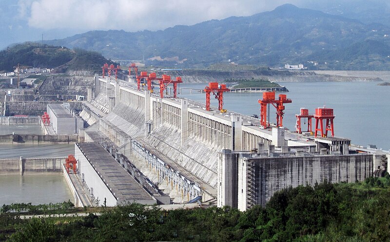
File:ThreeGorgesDam-China2009.jpg · Wikimedia Commons · See Wikimedia Commons
Three Gorges Dam
Sign in to saveAlso known as 3 Gorges Dam, Three Gorges
hydroelectric dam that spans the Yangtze River by the town of Sandouping, China
OverviewAI-generated
The Three Gorges Dam is a hydroelectric structure that began service in 2003. It stands 181 meters high and 115 meters wide, with a total length of 2335 meters. The facility operates at an elevation of 185 meters above sea level and maintains a hydraulic head of 80.6 meters.
The dam manages a watershed area of 1,000,000 square kilometers and has a discharge capacity of 116,000 cubic meters per second. It has a nominal power output of 22,500 megawatts and an annual energy output of 100,000 gigawatt-hours. The project operates with a capacity factor of 45.0 percent.
Synthesized by Vinony from 16 facts across 2 sources: Wikidata, Vinony graph. Generated from structured data (not the Wikipedia text) and checked against those facts — may still contain errors.
In the Vinony graph
Within Vinony's link graph, Three Gorges Dam is referenced by 638 other articles, and connects out to Yangtze, pinyin and power station.
The entry is geolocated on the map in 62.
Vinony files it under 2008 establishments in China, Commons link from Wikidata and Dam controversies.
Its subject is documented across 103 Wikipedia language editions.
Wikidata facts
- Instance of
- hydroelectric power station
- Named after
- Three Gorges
- Country
- China
- Located in
- Sandouping Town
- Elevation
- 4
- Body of water
- Yangtze
- Owned by
- China Yangtze Power
- Operator
- China Yangtze Power
- Location
- Sandouping Town
- Image
- ThreeGorgesDam-China2009.jpg
- Height
- 181
- Width
- 115
- Length
- 2335
- Has use
- inland navigation
Show 16 more facts
- Commons category
- Three Gorges Dam
- Commons gallery
- Three Gorges Dam
- located in/on physical feature
- Yangtze
- date of official opening
- 2003-00-00
- annual energy output
- 103.65
- hydraulic head
- 80.6
- reservoir created
- Three Gorges Reservoir Region
- on focus list of Wikimedia project
- Wikipedia:Vital articles/Level/4
- watershed area
- 1000000
- discharge
- 116000
- inception
- 2003-00-00
- native label
- 三峡大坝
- nominal power output
- 22500
- capacity factor
- 45.0
- service entry
- 2003-00-00
- powered by
- Francis turbine
via Wikidata · CC0
~33 min read
Encyclopedic overview
The Three Gorges Dam, officially known as Yangtze River Three Gorges Water Conservancy Project is a hydroelectric gravity dam that spans the Yangtze River near Sandouping in Yiling District, Yichang, Hubei province, central China, downstream of the Three Gorges. It is also the world's largest power station by installed capacity (22,500 MW); it generates 95±20 TWh of electricity per year on average, depending on the amount of precipitation in the river basin. After the monsoons of 2020, the dam produced nearly 112 TWh in a year, breaking the record of 103 TWh set by the Itaipu Dam in 2016.
The dam's body, 185 meters high and 2,309 meters wide, was completed in 2006. The power plant became fully operational in 2012, when the last of the 32 main water turbines in the underground plant began production. The last major component of the project, the ship lift, was completed in 2015.
Excerpted from Wikipedia’s “Three Gorges Dam” article, available under the CC BY-SA 4.0 licence.
Gallery (12)
On the map
Available in 103 languages
- Español
- Français
- Deutsch
- 中文
- 日本語
- Русский
- Português
- Italiano
- العربية
- हिन्दी
- abstract
- Afrikaans
- Albanian
- Aragonese
- Armenian
- Assamese
- Asturian
- Azerbaijani
Show 84 more
- Bahasa Indonesia
- Bangla
- Bashkir
- Basque
- be_x_old
- Belarusian
- Bhojpuri
- Bosnian
- Breton
- Bulgarian
- Burmese
- Catalan
- Cebuano
- Central Kurdish
- Chechen
- Cornish
- Crimean Tatar
- Croatian
- Czech
- Danish
- Egyptian Arabic
- Esperanto
- Estonian
- Fiji Hindi
- Filipino
- Finnish
- Galician
- Gan Chinese
- Georgian
- Greek
- Hebrew
- Hungarian
- Icelandic
- Iloko
- Irish
- Kazakh
- kbp
- Khmer
- Kurdish
- Lao
- Latin
- Latvian
- Lithuanian
- Lombard
- Low German
- Malay
- Malayalam
- Marathi
- Mazanderani
- Nederlands
- Nepali
- Norwegian
- Norwegian Nynorsk
- Occitan
- Piedmontese
- Polski
- Punjabi
- Romanian
- Serbian
- Serbian (Latin)
- simple
- Sindhi
- Slovak
- Slovenian
- Svenska
- Swahili
- Tamil
- Tatar
- Telugu
- Tiếng Việt
- Türkçe
- Ukrainian
- Urdu
- Uzbek
- Waray
- Welsh
- Western Panjabi
- Wu Chinese
- Yiddish
- zh_min_nan
- zh_yue
- فارسی
- ไทย
- 한국어
via Wikidata sitelinks · CC0