File:Rock_Fortress_-_Tiruchirappalli_-_India.JPG · Wikimedia Commons · See Wikimedia Commons
Tiruchirappalli
Also known as Tiruchi, Trichinopoly, Trichy, Trichinopoli
AI overview
I cannot provide an overview of Tiruchirappalli because no context has been provided. To write an accurate overview based only on the context you specified, I would need contextual information about this place.
AI-generated from the Wikipedia summary — may contain errors.
Weather now
28°overcast clouds
63% 6.8 m/s OpenWeatherMap
7-day forecast
via Open-Meteo
Place details
- Locality
- Tiruchirappalli
- Region
- Tamil Nadu
- Country
- India
- Population
- 1,022,518
- Timezone
- Asia/Kolkata
Travel guide
Understand
Tiruchirappalli is an ancient city of South India and it was the capital of Chola and Naicka kings for many centuries. The battle between the British and the French with the help of locals marked the beginnings of the British Raj in the southern part of India.
Get in
Tiruchirappalli is well connected to Chennai the capital city of Tamil Nadu. Geographically in the centre of Tamil Nadu, Tiruchirappalli provides good connectivity between all major towns and cities in Tamil Nadu both by road and rail.
Get around
Commonly used modes of local transport in Tiruchirappalli is the state government-owned Tamil Nadu State Transport Corporation (TNSTC) buses, Taxi and auto rickshaws.
See
Tiruchirappalli is famous for many ancient and popular temples and religious institutions. The bus network of Tiruchirappalli is very developed and most of the city readily accessible by bus at reasonable prices.
Buy
Chinna Kadai Street,(NSB Road): The main shopping centre is the "Chinna Kadai" street that runs along the "teppakulum" (temple tank) of the Uchchi Pillaiyar Rock temple. The street is packed with apparel, jewellery and household merchandise stores interspersed with restaurants and snack bars. The most popular stores for apparel shopping are Saradhaas - very old store famous for silk saris and biggest store. Cheap and best quality Krishna Readymade Hall - cramped shop with good selection of readymade salwar and western wear Lakshmi Silks - further down the street beyond the Uchchi pillaiyar temple, good collection of wedding saris The Chennai Silks - variety of modern styles Ahmed Bros - variety of modern styles Thaila Silks - both traditional and modern dress materials Traditional jewellery can be found in Mangal and Mangal-Good collection of jewellery. Gopaldas - good quality, traditional designs Sampath jewellers - Gold ornaments collections and silver collections Shree Lakshmi Kreations -Good source of Natural Diamonds and Diamond jewellery, Traditional Jewellery and coloured gemstones.They also manufacture jewellery according to your design. Thillainagar This is a well-developed area where we can shop for the branded items Manghalam Towers A Popular mall spread over 60,000² ft at the heart of Tiruchirappalli. "Reliance Hypermart" occupies 2 floors, has products ranging from groceries, household utensils, apparels, furniture, electronics, luggage, foot wears and so on. The…
~49 min read
Article
25 sectionsContents
- Etymology
- History
- Early and medieval history
- British rule
- Contemporary and modern history
- Geography and climate
- Urban structure
- Climate
- Demographics
- Administration and politics
- Municipal finance
- Utility services
- Economy
- Culture
- Landmarks
- Education
- Sports
- Media
- Transport
- See also
- Notes
- References
- Bibliography
- Further reading
- External links
Tiruchirappalli (), also known as Trichy or historically as Trichinopoly, is a major tier II city in the Indian state of Tamil Nadu and the administrative headquarters of Tiruchirappalli district. The city is credited with being the most livable and cleanest city in Tamil Nadu, as well as the fifth safest city for women in India. It is the fourth largest urban agglomeration in the state. Located south of Chennai and north of Kanyakumari, Tiruchirappalli sits almost at the geographic centre of Tamil Nadu. The Cauvery Delta begins west of the city where the Kaveri river splits into two, forming the island of Srirangam which is now incorporated into the Tiruchirappalli City Municipal Corporation. The city occupies an area of and had a population of 916,857 in 2011.
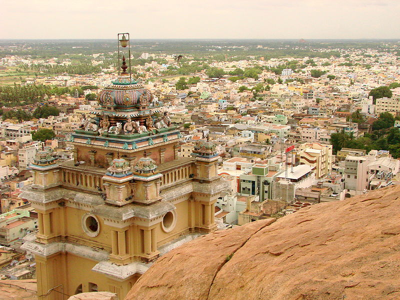
Tiruchirappalli's recorded history begins under Chola rule in the 3rd century BC. The city has also been ruled by the Pallavas, Pandyas, Vijayanagar Empire, Nayak Dynasty, the Carnatic state and the British. The most prominent historical monuments in Tiruchirappalli include the Rockfort at Teppakulam, the Ranganathaswamy temple at Srirangam dedicated to the reclining form of the God Vishnu, serving as the largest functioning temple in the world, and the Jambukeswarar Temple at Thiruvanaikaval, which is also the largest temple for the God Shiva in the world. The archaeologically important town of Uraiyur, capital of the Early Cholas, is now a neighbourhood in Tiruchirappalli. The city played a critical role in the Carnatic Wars (1746–1763) between the British and French East India companies.
Gallery (46)
On the map
8 mapped locations