
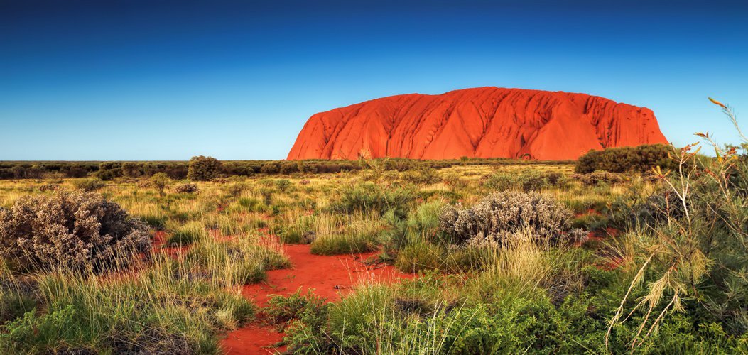
File:ULURU.jpg · Wikimedia Commons · See Wikimedia Commons
أولورو
Sign in to saveAlso known as Ayers Rock, Uluru/Ayers Rock, Uluru / Ayers Rock
تكوين صخري في أستراليا
Uluru, also known as Ayers Rock, is a massive sandstone rock formation located in central Australia near Alice Springs in the Northern Territory. It is significant as a prominent natural landmark in the Australian landscape and holds cultural importance for Indigenous Australian peoples.
AI-generated from the Wikipedia summary — may contain errors.
Key facts
- Mountain.name
- Uluru
- Mountain.other_name
- Ayers Rock
- Mountain.photo
- File:ULURU.jpg
- Mountain.photo_size
- 275px
- Mountain.elevation_m
- 863
- Mountain.prominence_m
- 348
- Mountain.location
- Northern Territory, Australia
- Mountain.map
- Northern Territory#Australia
- Mountain.type
- Inselberg
- Mountain.age
- 550–530 Ma
- Mountain.geology
- Arkose
- Mountain.mapframe
- yes
- Mountain.mapframe zoom
- 13
- Mountain.mapframe wikidata
- yes
- UNESCO World Heritage Site.Official_name
- Uluṟu-Kata Tjuṯa National Park
- UNESCO World Heritage Site.Criteria
- v, vi, vii, ix
- UNESCO World Heritage Site.ID
- 447
- UNESCO World Heritage Site.Year
- 1987
via Wikipedia infobox
Official website
Uluṟu-Kata Tjuṯa National Park | Parks Australia
Anangu welcome you to Uluru-Kata Tjuta National Park, a living cultural landscape where earth and memories exist as one.
environment.gov.au →Link to the official site · 12,258 chars · not written by Vinony
Wikidata facts
- Instance of
- inselberg
- Country
- Australia
- Located in
- Northern Territory
- Elevation
- 863
- Material used
- arkose
- Mass
- 1425000000
- Official website
- www.environment.gov.au/parks/uluru/index.html
- Image
- Sunset at Uluru on July 30, 2005.jpg
Show 9 more facts
- located in protected area
- Uluṟu-Kata Tjuṯa National Park
- topographic prominence
- 67
- Commons category
- Uluru
- Commons gallery
- Uluru
- time period
- Neoproterozoic
- topic's main category
- Category:Uluru
- name
- Roca de Ayers
- native label
- Uluru
- volume as quantity
- 0.6
Sources (6)
via Wikidata · CC0
Article · العربية
اولورو Uluṟu هو تكوين صخري يقع في الجزء الجنوبي من الإقليم الشمالي، وسط أستراليا على بعد 450 كم تقريباً، جنوب غربي . هي بقايا معزولة بعد التأكل البطيء لسلسلة الجبال الأصلية، تشكل وحدة متراصة من حبيبات «اركوس» وهي نوع من الحجر الرملي. أولورو مدرج على قائمة مواقع التراث العالمي. ارتفاعها يصل إلى 335م من بين سهول الكثبان الرملية. وترتفع ما يقرب من 876م، فوق سطح البحر. ويبلغ طول الصخرة أكثر من 2,4كم، وعرضها 1,6كم، ويبلغ محيط قاعدتها 8كم. يتغير لون أولورو حسب الاوقات المختلفة من اليوم والسنة، خاصة مع غروب الشمس، وعلى الرغم من هطول الأمطار النادر في هذه المنطقة شبه القاحلة تكتسب الصخور خلال الأمطار اللونين الفضي والرمادي.«اولورو» هي «جزيرة جبلية»،
Abstract from DBpedia / Wikipedia · CC BY-SA
Gallery (39)
On the map
3 mapped locations
Available in 90 languages
- Español
- Français
- Deutsch
- 中文
- 日本語
- Русский
- Português
- Italiano
- العربية
- हिन्दी
- Afrikaans
- Albanian
- Albanian
- Armenian
- Azerbaijani
- Bahasa Indonesia
- Balinese
- Basque
Show 71 more
- be_x_old
- Belarusian
- Betawi
- Breton
- Bulgarian
- Catalan
- Cebuano
- Croatian
- Czech
- Danish
- Egyptian Arabic
- Esperanto
- Estonian
- Faroese
- Filipino
- Finnish
- Galician
- Georgian
- Greek
- Hebrew
- Hungarian
- Icelandic
- Ido
- Inari Sami
- Interlingua
- Irish
- Kazakh
- Khmer
- Latin
- Latvian
- Lezghian
- Limburgish
- Lithuanian
- Luxembourgish
- Macedonian
- Malay
- Malayalam
- Maltese
- Māori
- Nederlands
- Nepali
- Northern Frisian
- Norwegian
- Norwegian Nynorsk
- Occitan
- Polski
- Punjabi
- Quechua
- Romanian
- Serbian
- Serbian (Latin)
- simple
- Sinhala
- Slovak
- Slovenian
- Svenska
- Swahili
- Tamil
- Tiếng Việt
- Toki Pona
- Türkçe
- Ukrainian
- Urdu
- Waray
- Welsh
- Western Panjabi
- Wu Chinese
- zh_yue
- فارسی
- ไทย
- 한국어
via Wikidata sitelinks · CC0