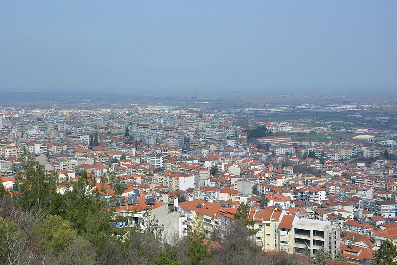
File:Panoramic_view_of_Veria_-_2014.JPG · Wikimedia Commons · See Wikimedia Commons
Veria
Sign in to saveAlso known as Berea, Beroia, Veroia
comune della Grecia nella periferia della Macedonia Centrale
OverviewAI-generated
Veria, known natively as Βέροια, is a city in Greece situated within the Central Macedonia Region. It serves as the capital of both the Imathia Regional Unit and the Veria Municipality. The city has a population of 43,394 and covers an area of 791 square kilometers. Its elevation above sea level is recorded as 128 meters, with other sources citing figures of 152 and 166 meters. Veria is twinned with Strovolos, Kazanlak, Rognac, and Užice.
The local dialing code for Veria is 2331, and its postal codes are 591 31 and 591 32. The city’s patron saint is Paul the Apostle. Veria replaced the historical settlement of Berroea. It is described in sources such as the Brockhaus and Efron Encyclopedic Dictionary and the Bible Encyclopedia of Archimandrite Nicephorus. The official website for the city is veria.gr.
Synthesized by Vinony from 51 facts across 7 sources: Wikidata, Open Meteo, Openweathermap, OpenStreetMap, GeoNames, Vinony graph, Geo. Generated from structured data (not the Wikipedia text) and checked against those facts — may still contain errors.
Weather now
7-day forecast
via Open-Meteo
Place details
- Locality
- Δήμος Βέροιας
- Region
- Περιφέρεια Κεντρικής Μακεδονίας
- Country
- Ελλάς
- Population
- 44,464
- Timezone
- Europe/Athens
via OpenStreetMap · GeoNames
Key facts
- Greek Dimos.name
- Veria
- Greek Dimos.name_local
- Βέροια
- Greek Dimos.type
- municipality
- Greek Dimos.image_map
- 2011 Dimos Verias.png
- Greek Dimos.periph
- Central Macedonia
- Greek Dimos.periphunit
- Imathia
- Greek Dimos.pop_municipality
- 62655
- Greek Dimos.area_municipality
- 796.5
- Greek Dimos.pop_municunit
- 46976
- Greek Dimos.area_municunit
- 359.1
- Greek Dimos.population_as_of
- 2021
- Greek Dimos.elevation
- 128
- Greek Dimos.postal_code
- 591 31, 591 32
- Greek Dimos.area_code
- 2331
- Greek Dimos.licence
- ΗΜ
- Greek Dimos.website
- www.veria.gr
- Greek Dimos.image_skyline
- Panoramic view of Veria - 2014.JPG
- Greek Dimos.caption_skyline
- Panoramic view
via Wikipedia infobox
Wikidata facts
- Instance of
- city
- Country
- Greece
- Population
- 43158
- Area
- 791
- Elevation
- 128
- Capital of
- Veria Municipality
- Official website
- www.veria.gr
- Image
- VeriaPanoramic.JPG
- Dialing code
- 2331
- Patron saint
- Paul the Apostle
Show 11 more facts
- twinned administrative body
- Strovolos
- Commons category
- Veria
- topic's main category
- Category:Veria
- category of associated people
- Category:People from Veria
- category for people born here
- Q10213026
- located in/on physical feature
- Central Macedonia Region
- postal code
- 591 32
- native label
- Βέροια
- replaces
- Berroea
- P8168
- Carsten Lund
- P12749
- Willoughby Newton
via Wikidata · CC0
Travel guide
Understand
The city lies on the foot of Mt Vermio. In the southeast area flows the Aliakmonas River, the longest river in Greece, with its tributaries, one of which, the Tripotamos, flows through the town.
The town is known as the Little Jerusalem because of the numerous Byzantine and post-Byzantine churches that it has (approximately 48 saved till today of 72 that were built). Veria has a very long history dating from antiquity and was one of the cities that St. Paul the Apostle visited during his second trip to Greece, in the 1st century AD.
Get in
Thessaloniki International Airport "Macedonia" is the closest international airport, 88 km (55 mi) northeast of Veria.
See
Other Ottoman monuments are: The old Cathedral of Metropolis, the Hunkiar mosque, the Kazaktsi and Orta mosque.
Do
Fishing, kayaking, canoeing, cycling (bikes can be rented in town) are some of the activities that can be done in the green landscape around the dam of Aliakmonas river, a few km south of the city center.
Go next
Vergina — One of the most important archaeological sites in Greece. The tomb of King Philip II, the father of Alexander the Great, was found there, as well as the gold urn with his bones. Edessa — On the way to Edessa the city with the amazing waterfalls, there are the Macedonian tombs in Palatitsia, the tombs of ancient Mieza and the Aristotle School. Further away, the spa town of Aridaia can be visited. Dion, Pieria — An archaeological area set in a lovely landscape at the foot of Mt Olympus Seli and Pigadia — Two Ski Centers on the sloops of Mt Vermio The Wine Route — The itinerary winds through the eastern slopes of Mount Vermio. Thymiopoulos, Boutari, and Dalamara vineyards possess museum rooms where the visitors can taste the regional wine.
Travel guide from Wikivoyage (CC BY-SA 4.0)
Article · Italiano
Veria o Veroia (in greco moderno: Βέροια) è un comune della Grecia situato nella periferia della Macedonia Centrale (unità periferica di Emazia) con 66.547 abitanti secondo i dati del censimento 2011. A seguito della riforma amministrativa detta Programma Callicrate in vigore dal gennaio 2011 che ha abolito le prefetture e accorpato numerosi comuni, la superficie del comune è ora di 791,4 km² e la popolazione è passata da 48.306 a 66.547 abitanti (censimento 2011). È situata ai piedi del .
Abstract from DBpedia / Wikipedia · CC BY-SA
Gallery (26)
On the map
2 mapped locations