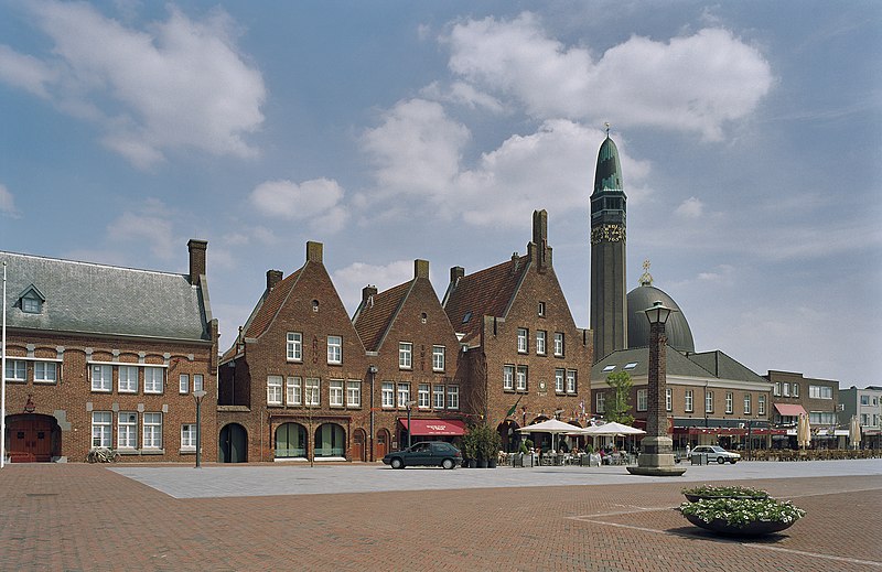
File:Overzicht_rechter_zijgevels_met_plein_en_rechts_de_Rooms_katholieke_kerk_Jan_de_Doper_-_Waalwijk_-_20350034_-_RCE.jpg · Wikimedia Commons · See Wikimedia Commons
Waalwijk
Sign in to saveAlso known as Wólluk, Wolluk
upright=1.35|thumb|Dutch topographic map of Waalwijk, July 2013 Waalwijk () is a municipality and a city in the southern Netherlands. It had a population of in and is located near the A59 and N261 motorways. The villages of Capelle, Vrijhoeve-Capelle, Sprang (the former municipality of Sprang-Capelle) and Waspik together with the city of Waalwijk form the municipality of Waalwijk. The city has an old town center, which has recently been modernized.
Key facts
- Settlement.name
- Waalwijk
- Settlement.settlement_type
- Municipality
- Settlement.image_skyline
- Overzicht rechter zijgevels met plein en rechts de Rooms katholieke kerk Jan de Doper - Waalwijk - 20350034 - RCE.jpg
- Settlement.image_caption
- Square in Waalwijk with restaurants and church
- Settlement.image_flag
- Waalwijk vlag.svg
- Settlement.flag_size
- 100x67px
- Settlement.image_shield
- Waalwijk wapen.svg
- Settlement.shield_size
- 100x80px
- Settlement.image_map
- Map - NL - Municipality code 0867 (2009).svg
- Settlement.map_alt
- Highlighted position of Waalwijk in a municipal map of North Brabant
- Settlement.map_caption
- Location in North Brabant
- Settlement.subdivision_type
- Country
- Settlement.subdivision_name
- Netherlands
- Settlement.subdivision_type1
- Province
- Settlement.subdivision_name1
- Noord-Brabant
- Settlement.governing_body
- Municipal council
- Settlement.leader_party
- Independent
- Settlement.leader_title
- Mayor
via Wikipedia infobox
Wikidata facts
- Instance of
- municipality of the Netherlands
- Demonym
- Waalwijker
- Country
- Netherlands
- Located in
- North Brabant
- Capital
- Waalwijk
- Population
- 48815
- Area
- 67.74
- Time zone
- UTC+01:00
- Shares border with
- Loon op Zand
- Official website
- www.waalwijk.nl
- Image
- Overzicht rechter zijgevels met plein en rechts de Rooms katholieke kerk Jan de Doper - Waalwijk - 20350034 - RCE.jpg
- Households
- 20112
Show 9 more facts
- twinned administrative body
- Chojnice
- Commons category
- Waalwijk
- postal code
- 5160–5165
- contains settlement
- Capelle
- topic's main category
- Category:Waalwijk
- category for people born here
- Category:Births in Waalwijk
- category of associated people
- Category:People from Waalwijk
- email address
- mailto:[email protected]
- phone number
- +31416683456
Sources (9)
via Wikidata · CC0
~4 min read
Encyclopedic overview
10 sectionsContents
- Population centers
- The city of Waalwijk
- International relations
- Twin towns — sister cities
- Notable people from Waalwijk
- Sport
- See also
- Gallery
- References
- External links
upright=1.35|thumb|Dutch topographic map of Waalwijk, July 2013 Waalwijk () is a municipality and a city in the southern Netherlands. It had a population of in and is located near the A59 and N261 motorways. The villages of Capelle, Vrijhoeve-Capelle, Sprang (the former municipality of Sprang-Capelle) and Waspik together with the city of Waalwijk form the municipality of Waalwijk. The city has an old town center, which has recently been modernized.
== Population centers ==
Excerpted from Wikipedia’s “Waalwijk” article, available under the CC BY-SA 4.0 licence.
Gallery (18)
On the map
3 mapped locations