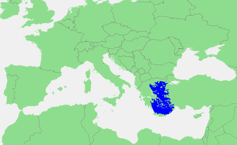
File:Location_of_the_Aegean_Sea.png · Wikimedia Commons · See Wikimedia Commons
Aegean Sea
Sign in to savepart of the Mediterranean Sea, between the Greek mainland, the Turkish mainland, Crete, and Rhodes
The Aegean Sea is a body of water in the Mediterranean located between Greece and Turkey, with several large Greek islands including Crete and Rhodes. It has been strategically and economically important throughout history as a major shipping route and cultural center connecting Europe and Asia.
AI-generated from the Wikipedia summary — may contain errors.
Wikidata facts
- Instance of
- drainage basin
- Part of
- Mediterranean Sea
- Has part
- Myrtoan Sea
- Named after
- Aegeus
- Country
- Turkey
- Area
- 214000
- Body of water
- Mediterranean Sea
- Image
- Aegeansea.jpg
- Connects with
- Levantine Sea
Show 9 more facts
- Commons gallery
- Aegean Sea
- Commons category
- Aegean Sea
- topic's main category
- Category:Aegean Sea
- described by source
- New International Encyclopedia
- basin country
- Turkey
- vertical depth
- 2100
- P8168
- huperzine A
- on focus list of Wikimedia project
- Wikipedia:Vital articles/Level/4
- native label
- Ege Denizi
via Wikidata · CC0
~31 min read
Encyclopedic overview
The extent of the Aegean Sea on a map of the Mediterranean Sea
The Aegean Sea is an elongated embayment of the Mediterranean Sea between Europe and Asia. It is located between the Balkans and Anatolia, and covers an area of some 215,000 km (83,000 sq mi). In the north, the Aegean is connected to the Marmara Sea, which in turn connects to the Black Sea, by the straits of the Dardanelles and the Bosphorus, respectively. The Aegean Islands are located within the sea and some bound it on its southern periphery, including Crete and Rhodes. The sea reaches a maximum depth of 2,639 m (8,658 ft) to the west of Karpathos. The Thracian Sea and the Sea of Crete are main subdivisions of the Aegean Sea.
Excerpted from Wikipedia’s “Aegean Sea” article, available under the CC BY-SA 4.0 licence.
Gallery (12)
On the map
2 mapped locations
Available in 141 languages
- Español
- Français
- Deutsch
- 中文
- 日本語
- Русский
- Português
- Italiano
- العربية
- हिन्दी
- Afrikaans
- Albanian
- Albanian
- Amharic
- Aragonese
- Armenian
- Asturian
- azb
Show 122 more
- Azerbaijani
- Bahasa Indonesia
- Balinese
- Bangla
- Bashkir
- Basque
- be_x_old
- Belarusian
- Bhojpuri
- Bikol
- Bosnian
- Breton
- Bulgarian
- Burmese
- Catalan
- cdo
- Central Kurdish
- Chechen
- Chuvash
- Corsican
- Crimean Tatar
- Croatian
- Czech
- Danish
- Egyptian Arabic
- Esperanto
- Estonian
- Extremaduran
- Fiji Hindi
- Filipino
- Finnish
- Galician
- Georgian
- Greek
- Haitian Creole
- Hebrew
- Hungarian
- hyw
- Icelandic
- Ido
- Iloko
- Interlingua
- Irish
- Javanese
- Kabyle
- Kazakh
- Kurdish
- Kyrgyz
- Latin
- Latvian
- Limburgish
- Lingua Franca Nova
- Lithuanian
- Lombard
- Low German
- Lower Sorbian
- Luxembourgish
- Macedonian
- Malagasy
- Malay
- Malayalam
- Maltese
- Marathi
- Mari
- Mazanderani
- Mingrelian
- Mongolian
- Moroccan Arabic
- Nederlands
- Newari
- Northern Frisian
- Norwegian
- Norwegian Nynorsk
- Occitan
- Old English
- olo
- Ossetic
- Pashto
- Polski
- Punjabi
- Romanian
- Rusyn
- Scottish Gaelic
- Serbian
- Serbian (Latin)
- Shona
- Sicilian
- simple
- Sindhi
- Slovak
- Slovenian
- Somali
- Svenska
- Swahili
- Tajik
- Tamil
- Tatar
- Telugu
- Tiếng Việt
- Türkçe
- Turkmen
- Udmurt
- Ukrainian
- Upper Sorbian
- Urdu
- Uyghur
- Uzbek
- Venetian
- Waray
- Welsh
- West Flemish
- Western Frisian
- Western Panjabi
- Wu Chinese
- Yakut
- Yiddish
- zh_classical
- zh_min_nan
- zh_yue
- فارسی
- ไทย
- 한국어
via Wikidata sitelinks · CC0