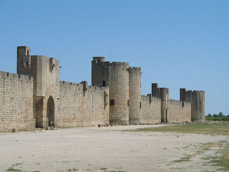
File:Aigues-Mortes_Walls_01.jpg · Wikimedia Commons · See Wikimedia Commons
Aigues-Mortes
Sign in to saveAlso known as Fort-Peletier
Aigues-Mortes (; ) is a commune in the Gard department in the Occitania region of southern France. The medieval city walls surrounding the city are well preserved. Situated on the junction of the Canal du Rhône à Sète and the Chenal Maritime to Le Grau-du-Roi, the town is a transit center for canal craft and Dutch barges.
OverviewAI-generated
Aigues-Mortes is a commune in the Gard department of France, situated within the arrondissement of Nîmes and the Occitanie region. It serves as the capital of the canton of Aigues-Mortes. The town borders Les Saintes-Maries-de-la-Mer, Le Grau-du-Roi, Saint-Laurent-d'Aigouze, and Marsillargues. Its official name is Aigues-Mortes, Fort-Peletier, and it is led by head of government Maurice Fontaine.
The commune has an area of 57.78 square kilometers and an elevation of 3 meters above sea level. The population is recorded as 8,707, comprising 3,979 males and 4,346 females. The earliest written record of the location dates to 102 BCE. Aigues-Mortes is described in sources such as the Brockhaus and Efron Encyclopedic Dictionary and the Encyclopædia Britannica 11th edition.
Synthesized by Vinony from 51 facts across 7 sources: Wikidata, Openweathermap, Open Meteo, OpenStreetMap, GeoNames, Vinony graph, Geo. Generated from structured data (not the Wikipedia text) and checked against those facts — may still contain errors.
Weather now
7-day forecast
via Open-Meteo
Place details
- Locality
- Aigues-Mortes
- Region
- Occitanie
- Country
- France
- Population
- 6,526
via OpenStreetMap · GeoNames
Key facts
- French commune.image coat of arms
- Blason ville fr Aigues-Mortes (Gard).svg
- French commune.arrondissement
- Nîmes
- French commune.canton
- Aigues-Mortes
- French commune.INSEE
- 30003
- French commune.postal code
- 30220
- French commune.mayor
- Pierre Mauméjean
- French commune.term
- 2020–2026
- French commune.intercommunality
- Terre de Camargue
- French commune.elevation m
- 1
- French commune.elevation min m
- 0
- French commune.name
- Aigues-Mortes
- French commune.commune status
- Commune
- French commune.image
- Aigues-Mortes Walls 01.jpg
- French commune.caption
- City walls
- French commune.elevation max m
- 3
- French commune.area km2
- 57.78
- French commune.demonym
- Aigues-Mortais (masculine)Aigues-Mortaise (feminine)
via Wikipedia infobox
Wikidata facts
- Instance of
- commune of France
- Official name
- Fort-Peletier
- Country
- France
- Located in
- arrondissement of Nîmes
- Population
- 8699
- Area
- 57.78
- Elevation
- 1
- Time zone
- UTC+02:00
- Shares border with
- La Grande-Motte
- Official website
- ville-aigues-mortes.fr
- Image
- Aigues-Mortes, France 2022.jpg
Show 14 more facts
- postal code
- 30220
- Commons category
- Aigues-Mortes
- topic's main category
- Category:Aigues-Mortes
- Commons gallery
- Aigues-Mortes
- described by source
- Encyclopædia Britannica 11th edition
- native label
- Aigues-Mortes
- associated electoral district
- canton of Aigues-Mortes
- male population
- 3979
- female population
- 4346
- P8168
- Franz Anton Bagnato
- time of earliest written record
- 0102-00-00
- email address
- mailto:[email protected]
- phone number
- +33-4-66-73-90-90
- fax number
- +33-4-66-53-86-09
Sources (9)
via Wikidata · CC0
Travel guide
Get in
thumb|250px|View along the ramparts to the Constance Tower
Get around
The historical centre is all contained within a compact area of the city walls, easily explored on foot.
See
Aigues Mortes is a nice fortified city, where it's possible to visit the ramparts, the walk through the village and the nearby Salt Works.
Do
Walk around the ramparts of the medieval city walls, and see inside the various towers, including the Constance Tower. This costs money. The ticket office, located in the North West corner, offers audio guides, but is closed at lunchtime.
Buy
Lots of shops selling tourist nick-nacks
Eat
There are many pleasant cafes and restaurants within the city walls, particularly around the central square.
Sushi Shu Japanese Restaurant
Go next
The cities of Montpellier and Nimes are closest to Aigues-Mortes.
La Camargue delta of the River Rhone.
Travel guide from Wikivoyage (CC BY-SA 4.0)
~32 min read
Encyclopedic overview
43 sectionsContents
- Name
- History
- Antiquity
- Middle Ages
- Modern and contemporary periods
- The massacre of Italians (August 1893)
- Geography
- Climate
- Heraldry
- Economy
- Agriculture
- Industries
- Tourism
- Transport
- River
- Railway
- Road
- Administration
- Municipal administration
- Canton
- Population
- Age distribution
- Local culture
- The Aigues-Mortes Fougasse
- Lou Drapé
- Historical sites
- The Tower of Constance and the ramparts
- The Carbonnière Tower
- The Church of Notre-Dame-des-Sablons
- The Chapel of the Gray Penitents
- The Chapel of the White Penitents
- Saint-Louis Square
- Plan des Theatres
- Aerial views
- In popular culture
- Literary references
- Architectural references
- Notable people linked to the commune
- Gallery
- See also
- References
- Bibliography
- External links
Aigues-Mortes (; ) is a commune in the Gard department in the Occitania region of southern France. The medieval city walls surrounding the city are well preserved. Situated on the junction of the Canal du Rhône à Sète and the Chenal Maritime to Le Grau-du-Roi, the town is a transit center for canal craft and Dutch barges.
== Name == The name "Aigues-Mortes" was attested in 1248 in the Latinized form '', which means "dead water", or "stagnant water". The name comes from the marshes and ponds that surround the village (which has never had potable water). The inhabitants of the commune are known as Aigues-Mortais or Aigues-Mortaises in French.
Excerpted from Wikipedia’s “Aigues-Mortes” article, available under the CC BY-SA 4.0 licence.
Gallery (34)
On the map
3 mapped locations
Available in 62 languages
- Español
- Français
- Deutsch
- 中文
- 日本語
- Русский
- Português
- Italiano
- العربية
- Afrikaans
- Albanian
- Aragonese
- Armenian
- Bahasa Indonesia
- Basque
- Breton
- Buginese
- Catalan
Show 43 more
- Cebuano
- Chechen
- Czech
- Egyptian Arabic
- Esperanto
- Finnish
- Greek
- Hungarian
- Kazakh
- Kurdish
- Latin
- Lithuanian
- lld
- Lombard
- Luxembourgish
- Malagasy
- Malay
- Nederlands
- Occitan
- Pampanga
- Piedmontese
- Polski
- Romanian
- Serbian
- Serbian (Latin)
- Silesian
- simple
- Slovak
- Slovenian
- Svenska
- Tatar
- Tiếng Việt
- Türkçe
- Ukrainian
- Urdu
- Uzbek
- Venetian
- Volapük
- Waray
- zh_min_nan
- zh_yue
- فارسی
- 한국어
via Wikidata sitelinks · CC0