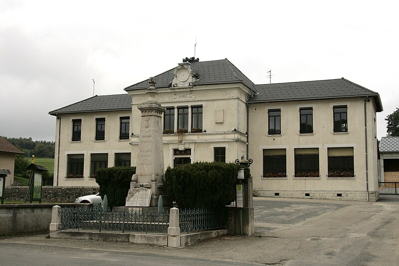
File:Marie_Aranc.jpg · Wikimedia Commons · See Wikimedia Commons
Aranc
Sign in to saveAranc () is a commune in the department of Ain in the Auvergne-Rhône-Alpes region of eastern France.
OverviewAI-generated
Aranc is a commune in France, situated within the Ain department and the arrondissement of Belley. It lies in the Auvergne-Rhône-Alpes region and shares borders with Corlier, Évosges, Hauteville-Lompnes, and Izenave. The municipality covers an area of 21.65 square kilometers and has an elevation of 1011 meters above sea level.
The population of Aranc is 331, comprising 167 males and 159 females. It is part of the canton of Plateau d'Hauteville and uses the postal code 01110. The local government can be reached via the official website or by phone at +33-4-74-38-57-05.
Synthesized by Vinony from 47 facts across 7 sources: Wikidata, Open Meteo, Openweathermap, OpenStreetMap, GeoNames, Vinony graph, Geo. Generated from structured data (not the Wikipedia text) and checked against those facts — may still contain errors.
Weather now
7-day forecast
via Open-Meteo
Place details
- Locality
- Aranc
- Region
- Auvergne-Rhône-Alpes
- Country
- France
- Population
- 305
via OpenStreetMap · GeoNames
Key facts
- French commune.name
- Aranc
- French commune.commune status
- Commune
- French commune.image
- Marie Aranc.jpg
- French commune.caption
- Town hall
- French commune.image coat of arms
- Blason ville fr Aranc (Ain).svg
- French commune.arrondissement
- Belley
- French commune.canton
- Plateau d'Hauteville
- French commune.INSEE
- 01012
- French commune.postal code
- 01110
- French commune.mayor
- Daniel Mathieu
- French commune.term
- 2020–2026
- French commune.intercommunality
- Haut-Bugey Agglomération
- French commune.elevation m
- 750
- French commune.elevation min m
- 431
- French commune.elevation max m
- 1011
- French commune.area km2
- 21.65
via Wikipedia infobox
Wikidata facts
- Instance of
- commune of France
- Official name
- Aranc
- Country
- France
- Located in
- arrondissement of Belley
- Population
- 331
- Area
- 21.65
- Elevation
- 791
- Time zone
- UTC+02:00
- Shares border with
- Corcelles
- Official website
- www.aranc.info
- Image
- Marie Aranc.jpg
Show 9 more facts
- Commons category
- Aranc
- postal code
- 01110
- associated electoral district
- canton of Plateau d'Hauteville
- male population
- 167
- female population
- 159
- P8168
- Concesio
- email address
- mailto:[email protected]
- phone number
- +33-4-74-38-57-05
- fax number
- +33-4-37-61-09-72
Sources (4)
via Wikidata · CC0
~20 min read
Encyclopedic overview
40 sectionsContents
- Geography
- Location
- Geology
- History
- Heraldry
- Etymology
- Prehistory
- Middle Ages
- 16th and 17th centuries
- 18th century
- 19th century
- Second World War
- Administration
- Hamlets
- Rougemont
- Résinand
- Les Pézières
- Salagnat
- Population
- Amenities
- Education
- Associations
- Sport
- Economy
- Employment
- Business
- Commerce
- Heritage
- Sights
- Saint Paul's Church
- Open Air Crosses
- Administrative buildings
- Other buildings
- Farms and Barns
- Houses
- Legends and oral traditions
- Springs, fountains, streams and rivers
- See also
- References
- External links
Aranc () is a commune in the department of Ain in the Auvergne-Rhône-Alpes region of eastern France.
==Geography==
Excerpted from Wikipedia’s “Aranc” article, available under the CC BY-SA 4.0 licence.
Gallery (16)
On the map
2 mapped locations
Available in 60 languages
- Español
- Français
- Deutsch
- 中文
- Русский
- Português
- Italiano
- العربية
- Albanian
- Aragonese
- Armenian
- Asturian
- Azerbaijani
- Bahasa Indonesia
- Basque
- Buginese
- Catalan
- Cebuano
Show 41 more
- Chechen
- Egyptian Arabic
- Esperanto
- Filipino
- Finnish
- Galician
- Hungarian
- Kara-Kalpak
- Kurdish
- Latin
- Lombard
- Luxembourgish
- Malagasy
- Malay
- Nederlands
- Northern Sami
- Occitan
- Pampanga
- Piedmontese
- Polski
- Romanian
- Serbian
- Serbian (Latin)
- simple
- Slovak
- Svenska
- Tatar
- Tiếng Việt
- Türkçe
- Ukrainian
- Urdu
- Uzbek
- Venetian
- Waray
- Wu Chinese
- Zaza
- Zeelandic
- zh_min_nan
- zh_yue
- فارسی
- 한국어
via Wikidata sitelinks · CC0