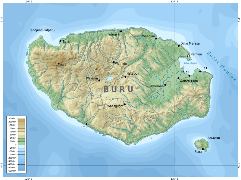
File:Topographic_map_of_Buru-en.svg · Wikimedia Commons · See Wikimedia Commons
Buru Island
Sign in to saveAlso known as Pulau Buru, Boeroe, Buru
Buru (formerly spelled Boeroe, Boro, or Bouru) is the third largest island within the Maluku Islands of Indonesia. It lies between the Banda Sea to the south and Seram Sea to the north, west of Ambon and Seram islands. The island belongs to Maluku province and includes the Buru and South Buru regencies. Their administrative centers, Namlea and Namrole, respectively, have ports and are the largest towns of the island, served by Namlea Airport and Namrole Airport respectively.
Buru Island is the third largest island in Indonesia's Maluku Islands, located between the Banda Sea and Seram Sea and administratively divided into two regencies centered on the port towns of Namlea and Namrole. The island serves as a regional hub with two airports and is part of Maluku province.
AI-generated from the Wikipedia summary — may contain errors.
Key facts
- Islands.name
- Buru
- Islands.image_name
- Topographic map of Buru-en.svg
- Islands.map_image
- ID Buru.PNG
- Islands.location
- Oceania
- Islands.archipelago
- Maluku Islands
- Islands.area_km2
- 9,505
- Islands.highest_mount
- Mount Kapalatmada
- Islands.elevation_m
- 2428
- Islands.country
- Indonesia
- Islands.country_admin_divisions_title
- Province
- Islands.country_admin_divisions
- Maluku
- Islands.country_largest_city
- Namlea
- Islands.country_largest_city_population
- 37,869
- Islands.population
- 215,277
- Islands.population_as_of
- 2020 Census
- Islands.density_km2
- 17.0
- Islands.ethnic_groups
- Buru, Lisela, Ambelau, Kayeli, Masarete, Rana, Wai Apu, and (native)Ambonese, Butonese, Javanese, Bugis, Sula, Tobelo, and others (migrant)
- Islands.timezone1
- IEST
via Wikipedia infobox
Wikidata facts
- Instance of
- island
- Part of
- Maluku Islands
- Country
- Indonesia
- Located in
- Maluku
- Population
- 124000
- Area
- 80516.0709
- Elevation
- 551
- Body of water
- Banda Sea
- Highest point
- Mount Kapalatmada
- Location
- Banda Sea
- Image
- Topographic map of Buru-en.svg
Show 4 more facts
- described by source
- Brockhaus and Efron Encyclopedic Dictionary
- Commons category
- Buru
- native label
- Pulau Buru
- name
- Buru
Sources (3)
via Wikidata · CC0
~29 min read
Encyclopedic overview
19 sectionsContents
- Geography and geology
- Climate
- Flora and fauna
- Administrative division
- Population
- History
- Precolonial period
- Colonial period
- Transition years 1942–1950
- As part of Indonesia
- Economy
- Transportation
- Health
- Traditional occupations and culture
- Research
- See also
- References
- Further reading
- External links
Buru (formerly spelled Boeroe, Boro, or Bouru) is the third largest island within the Maluku Islands of Indonesia. It lies between the Banda Sea to the south and Seram Sea to the north, west of Ambon and Seram islands. The island belongs to Maluku province and includes the Buru and South Buru regencies. Their administrative centers, Namlea and Namrole, respectively, have ports and are the largest towns of the island, served by Namlea Airport and Namrole Airport respectively.
About a third of the population is indigenous, mostly the Buru, but also the Lisela, Ambelau, Kayeli, Masarete, Rana, Wai Apu, and . The rest of population are immigrants from Java and nearby Maluku Islands. Religious affiliation is evenly split between Christianity and Sunni Islam, with some remnants of traditional beliefs. While local languages and dialects are spoken within individual communities, the national Indonesian language is used among the communities and by the administration. Most of the island is covered with forests rich in tropical flora and fauna. From the present 179 bird and 25 mammal species, about 14 are found either on Buru only or also on a few nearby islands, the most notable being the wild pig Buru babirusa. There is little industry on the island, and most population is engaged in growing rice, maize, sweet potato, beans, coconuts, cocoa, coffee, clove and nutmeg. Other significant activities are animal farming and fishing.
Excerpted from Wikipedia’s “Buru Island” article, available under the CC BY-SA 4.0 licence.
Gallery (26)
On the map
3 mapped locations