布魯島
Also known as Pulau Buru, Boeroe, Buru
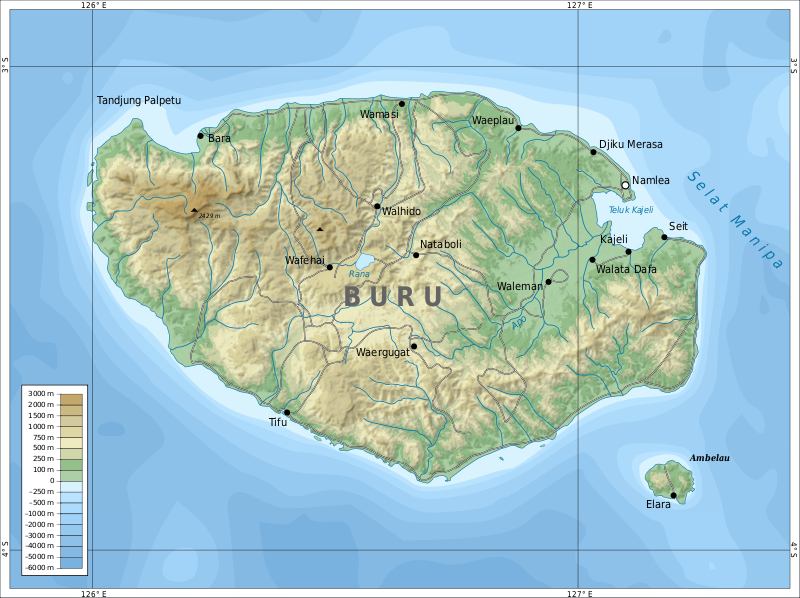
Buru (formerly spelled Boeroe, Boro, or Bouru) is the third largest island within the Maluku Islands of Indonesia. It lies between the Banda Sea to the south and Seram Sea to the north, west of Ambon and Seram islands. The island belongs to Maluku province and includes the Buru and South Buru regencies. Their administrative centers, Namlea and Namrole, respectively, have ports and are the largest towns of the island, served by Namlea Airport and Namrole Airport respectively.
AI overview
Buru Island is the third largest island in Indonesia's Maluku Islands, located between the Banda Sea and Seram Sea and administratively divided into two regencies centered on the port towns of Namlea and Namrole. The island serves as a regional hub with two airports and is part of Maluku province.
AI-generated from the Wikipedia summary — may contain errors.
Key facts
- Islands.name
- Buru
- Islands.image_name
- Topographic map of Buru-en.svg
- Islands.map_image
- ID Buru.PNG
- Islands.location
- Oceania
- Islands.archipelago
- Maluku Islands
- Islands.area_km2
- 9,505
- Islands.highest_mount
- Mount Kapalatmada
- Islands.elevation_m
- 2428
- Islands.country
- Indonesia
- Islands.country_admin_divisions_title
- Province
- Islands.country_admin_divisions
- Maluku
- Islands.country_largest_city
- Namlea
- Islands.country_largest_city_population
Article · 中文
布魯島(印尼語:Pulau Buru),清代書籍譯作武羅、木魯、布盧,又譯務羅、未羅、普路、布襦、部魯,是印度尼西亞摩鹿加省的熱帶小島,位於安汶島和斯蘭島以西,面積8,473平方公里,是摩鹿加群島的第三大島嶼,2012年人口約206,840,其中80%居民住在沿海的平原。岛中部有拉纳湖。行政上布鲁岛分属布鲁县和南布鲁县。
Abstract from DBpedia / Wikipedia · CC BY-SA
Gallery (26)
On the map
3 mapped locations