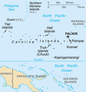
File:Caroline_Islands-map.gif · Wikimedia Commons · See Wikimedia Commons
Caroline Islands
Sign in to saveAlso known as Carolines, the Carolines, New Philippines, Nuevas Filipinas, Isles of the Kings, Islands of the Kings, Chickpea Islands, Islas de los Reyes
archipelago of tiny islands in the western Pacific Ocean, divided between the Federated States of Micronesia and Palau
The Caroline Islands are a chain of small islands located in the western Pacific Ocean that are split between two independent nations: the Federated States of Micronesia and Palau. These islands matter as distinct political entities and cultural regions in the Pacific, and they serve as important territories in one of the world's most remote ocean areas.
AI-generated from the Wikipedia summary — may contain errors.
Wikidata facts
- Instance of
- archipelago
- Has part
- Kosrae
- Named after
- Charles II of Spain
- Located in
- German New Guinea
- Population
- 125000
- Area
- 1160
- Elevation
- 791
- Time zone
- UTC+09:00
- Body of water
- Pacific Ocean
- Highest point
- Dolohmwar
- Image
- Mvey0290.jpg
- Perimeter
- 7631
Show 4 more facts
- Commons category
- Caroline Islands
- topic's main category
- Category:Caroline Islands
- different from
- Caroline Island
- native label
- Carolinas Islas
via Wikidata · CC0
~17 min read
Encyclopedic overview
Navigator Mau Piailug (1932–2010) of Satawal island, Micronesia Rai stones on Yap
The Caroline Islands (or the Carolines) are a widely scattered archipelago of tiny islands in the western Pacific Ocean, to the north of New Guinea. Politically, they are divided between the Federated States of Micronesia (FSM) in the central and eastern parts of the group, and Palau at the extreme western end. Historically, this area was also called Nuevas Filipinas or New Philippines, because they were part of the Spanish East Indies and were governed from Manila in the Philippines.
Excerpted from Wikipedia’s “Caroline Islands” article, available under the CC BY-SA 4.0 licence.
Gallery (10)
On the map
Available in 66 languages
- Español
- Français
- Deutsch
- 中文
- 日本語
- Русский
- Português
- Italiano
- العربية
- हिन्दी
- Afrikaans
- Armenian
- Asturian
- Azerbaijani
- Bahasa Indonesia
- Basque
- Belarusian
- Breton
Show 47 more
- Bulgarian
- Catalan
- Czech
- Danish
- Esperanto
- Estonian
- Finnish
- Galician
- Georgian
- Greek
- Hebrew
- Hungarian
- Icelandic
- Ido
- Kyrgyz
- Latin
- Latvian
- Lithuanian
- Macedonian
- Malay
- Mongolian
- Nederlands
- Northern Frisian
- Norwegian
- Norwegian Nynorsk
- Polski
- Punjabi
- Romanian
- Serbian
- simple
- Slovenian
- Svenska
- Swahili
- Telugu
- Tiếng Việt
- Türkçe
- Ukrainian
- Upper Sorbian
- Uzbek
- Waray
- Western Frisian
- Wu Chinese
- zh_min_nan
- zh_yue
- فارسی
- ไทย
- 한국어
via Wikidata sitelinks · CC0