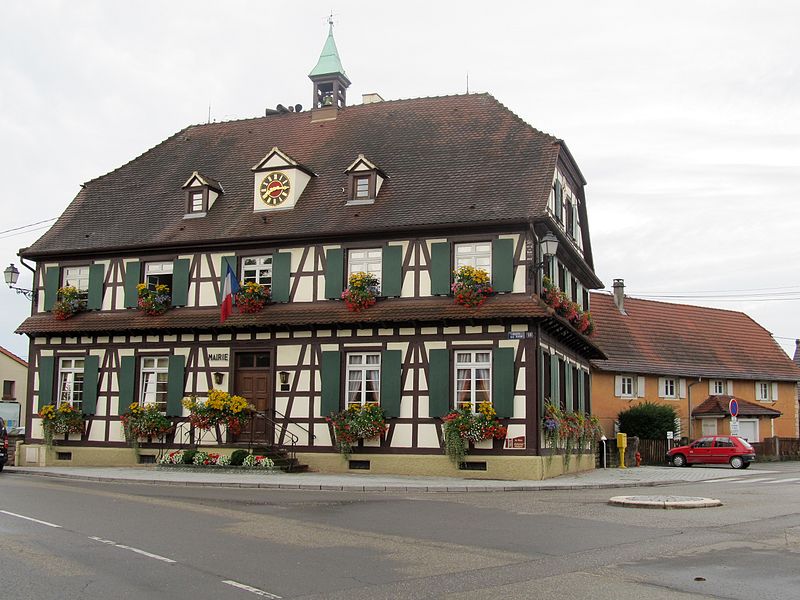
File:Gambsheim-2.jpg · Wikimedia Commons · See Wikimedia Commons
Gambsheim
Sign in to saveGambsheim is a commune in the Bas-Rhin department and Grand Est region of north-eastern France, in the historical region of Alsace.
OverviewAI-generated
Gambsheim is a commune in France, situated in the Grand Est region. It lies within the Bas-Rhin department and the arrondissement of Haguenau-Wissembourg, having also been part of the arrondissement of Strasbourg-Campagne. The town is located in the Unterelsaß area and borders Kilstett, Offendorf, La Wantzenau, and Weyersheim. It is positioned near the Rhine and Ill bodies of water.
The commune has an area of 17.38 square kilometers and an elevation of 131 meters above sea level. Its population is recorded as 5,312, comprising 2,405 males and 2,478 females. Gambsheim uses the postal code 67760 and is associated with the canton of Brumath. The local name for the town is Gàmbse.
Synthesized by Vinony from 44 facts across 7 sources: Wikidata, Openweathermap, OpenStreetMap, GeoNames, Open Meteo, Vinony graph, Geo. Generated from structured data (not the Wikipedia text) and checked against those facts — may still contain errors.
In the Vinony graph
The entry is geolocated on the map, across 2 mapped points.
Within Vinony's link graph, Gambsheim is referenced by 536 other articles, and connects out to France, time zone and Strasbourg.
It is catalogued under topics including Bas-Rhin communes articles needing translation from French Wikipedia, Communes of Bas-Rhin and Geography articles needing translation from French Wikipedia.
Its subject is documented across 45 Wikipedia language editions.
Weather now
cached 6h ago7-day forecast
via Open-Meteo
Place details
- Locality
- Gambsheim
- Region
- Grand Est
- Country
- France
- Population
- 4,071
- Timezone
- Europe/Paris
via OpenStreetMap · GeoNames
Key facts
- French commune.name
- Gambsheim
- French commune.native name
- Gàmbse
- French commune.commune status
- Commune
- French commune.image
- Gambsheim-2.jpg
- French commune.caption
- Gambsheim town hall
- French commune.image coat of arms
- Blason ville fr Gambsheim (Bas-Rhin).svg
- French commune.arrondissement
- Haguenau-Wissembourg
- French commune.canton
- Brumath
- French commune.INSEE
- 67151
- French commune.postal code
- 67760
- French commune.mayor
- Hubert Hoffmann
- French commune.term
- 2020–2026
- French commune.intercommunality
- Pays Rhénan
- French commune.elevation min m
- 126
- French commune.elevation max m
- 131
- French commune.area km2
- 17.38
via Wikipedia infobox
Wikidata facts
- Instance of
- commune of France
- Official name
- Gambsheim
- Country
- France
- Located in
- arrondissement of Strasbourg-Campagne
- Population
- 5312
- Area
- 17.38
- Elevation
- 128
- Time zone
- UTC+02:00
- Body of water
- Ill
- Shares border with
- Weyersheim
- Official website
- mairie-gambsheim.fr
- Image
- Gambsheim Mairie (3).JPG
Show 9 more facts
- Commons category
- Gambsheim
- postal code
- 67760
- associated electoral district
- canton of Brumath
- male population
- 2405
- female population
- 2478
- P8168
- glutinous rice
- email address
- mailto:[email protected]
- phone number
- +33-3-88-59-79-59
- native label
- Gàmbse
via Wikidata · CC0
~1 min read
Encyclopedic overview
6 sectionsContents
- Geography
- Population
- Landmarks
- See also
- References
- External links
Gambsheim is a commune in the Bas-Rhin department and Grand Est region of north-eastern France, in the historical region of Alsace.
==Geography== Gambsheim lies adjacent to a river-crossing into Germany that is favoured by southbound traffic on the A35 autoroute wishing to avoid traffic delays around Strasbourg. The crossing coincides with the location of a large river lock which, like the similar French-German cooperation project at Iffezheim Lock, is also the site of a power station and one of the Rhine's first fish ladders. The latter was installed to support migratory fish in general and, more specifically, in an attempt to restore the abundant salmon population for which the upper Rhine was famous before the early 20th century, when the installation of a series of locks rendered the river navigable beyond Basel for boats, but blocked it for migrating fish.
Excerpted from Wikipedia’s “Gambsheim” article, available under the CC BY-SA 4.0 licence.
Gallery (2)
On the map
2 mapped locations