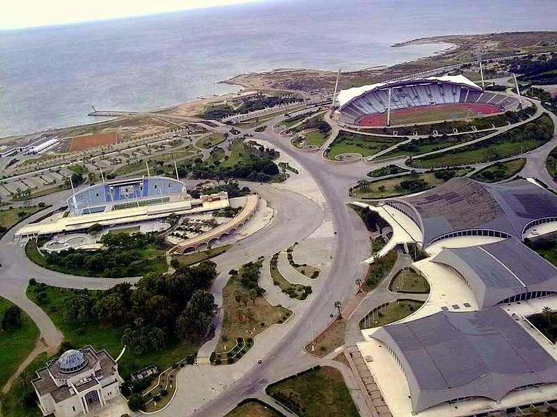
File:Latakia_Sports_City_aerial_view_in_1991.jpg · Wikimedia Commons · See Wikimedia Commons
OverviewAI-generated
Latakia is a big city in Syria, located in the Lattakia Subdistrict. It serves as the capital of Latakia Governorate and Latakia District. The city covers an area of 58 square kilometers and has a population of 709000. Its elevation is recorded at 0 meters above sea level, though other sources list it at 26 or 29 meters. The local dialing code is 041.
Latakia is twinned with Sousse, Mersin, Constanța, and Rimini. It replaces the historical entity Laodicea and is distinct from Laodicea on the Lycus. The city is described by sources including The Nuttall Encyclopædia, the Jewish Encyclopedia of Brockhaus and Efron, and the Encyclopædia Britannica 11th edition. A significant event in its history is the Siege of Latakia. Its official name is اللاذقية.
Synthesized by Vinony from 51 facts across 7 sources: Wikidata, Open Meteo, Openweathermap, OpenStreetMap, GeoNames, Vinony graph, Geo. Generated from structured data (not the Wikipedia text) and checked against those facts — may still contain errors.
Weather now
7-day forecast
via Open-Meteo
Place details
- Locality
- الدباغة
- Region
- محافظة اللاذقية
- Country
- سوريا
- Population
- 709,000
- Timezone
- Asia/Damascus
via OpenStreetMap · GeoNames
Key facts
- Settlement.name
- Latakia
- Settlement.official_name
- Lattakia
- Settlement.named_for
- Laodice of Macedonia
- Settlement.nickname
- "Bride of the Mediterranean"
- Settlement.settlement_type
- City
- Settlement.image_shield
- Coat of Arms of Latakia.svg
- Settlement.mapframe
- yes
- Settlement.mapframe zoom
- 11
- Settlement.mapframe wikidata
- yes
- Settlement.pushpin_map
- Syria#Mediterranean east#Asia
- Settlement.pushpin_relief
- yes
- Settlement.pushpin_map_caption
- Location of Latakia within Syria
- Settlement.subdivision_type
- Country
- Settlement.subdivision_type1
- Governorate
- Settlement.subdivision_name1
- Latakia Governorate
- Settlement.subdivision_type2
- District
- Settlement.subdivision_name2
- Latakia District
- Settlement.subdivision_type3
- Subdistrict
via Wikipedia infobox
Wikidata facts
- Official name
- اللاذقية
- Country
- Syria
- Located in
- Lattakia Subdistrict
- Population
- 709000
- Area
- 58
- Elevation
- 0
- Capital of
- Latakia District
- Official website
- www.elatakia.sy
- Image
- Latakia Collage.jpg
- Dialing code
- 041
- Significant event
- Siege of Latakia
Show 10 more facts
- Commons category
- Latakia
- topic's main category
- Category:Latakia
- category for people born here
- Category:Births in Latakia
- category for people who died here
- Category:Deaths in Latakia
- category of associated people
- Category:People from Latakia
- described by source
- Encyclopædia Britannica 11th edition
- native label
- اللاذقية
- different from
- Laodicea on the Lycus
- replaces
- Laodicea
- P12749
- June 10
Sources (8)
via Wikidata · CC0
Travel guide
Understand
thumb|Welcome sign on the Latakia Train Station The city consists largely of white stucco highrises and streets lined with palm trees, and the most popular beaches are along the coast to the north of the city. Latakia is home to one of Syria's largest universities, Latakia University, and the city tends to be relatively socially progressive and liberal (by Syrian standards), with a mixed population of Christian, Alawi, and Sunni inhabitants.
Get around
Much of Latakia is accessible by taxi.
One can walk along the corniche, although it is otherwise not a very walkable city, due to distances between points in the city (beach, downtown, resort hotels, Ugarit, etc.).
See
thumbnail|Saladin's castle
The Latakia region is known for its diversity of landscapes, from the green mountains to the sandy beaches, with many important archeological sites, such as the Saladin Castle (a UNESCO World Heritage Site since 2006) and the ruins of Ugarit, close enough to see on a day trip from Latakia.
Do
thumb|View of the beach from Al Siwar Restaurant In the city center, the American street attracts the young and fashionable at night.
Also the Zira'a quarter and around the university are hip upcoming parts of the city.
Travel guide from Wikivoyage (CC BY-SA 4.0)
Article · Français
Lattaquié [latakje] (en arabe : اللاذقية / al-lāḏiqiyya), est une ville de Syrie, chef-lieu du gouvernorat homonyme. La ville était en 2004 la quatrième ville la plus peuplée du pays avec 383 786 habitants, appelés en français les Lattaquiotes. Cette ville est établie sur un site très anciennement occupé, proche de l'ancienne Ougarit. La cité qui fut un chef-lieu de satrapie sous le royaume séleucide portait alors le nom de Laodicée-de-Syrie ou Laodicée-sur-Mer (en grec ancien : Λαοδίκεια ἡ Πάραλος / Laodíkeia hē Páralos ; en latin : Laodicea ad Mare) parce qu'elle a été refondée par Séleucos Ier qui a donné à la ville le nom de sa mère Laodicé et de sa . Après la domination romaine et byzantine, elle fit partie, à l’époque des croisades, de la principauté d'Antioche, avant de retomber aux mains des Mamelouks puis des Turcs (Empire ottoman). Pendant l'entre-deux-guerres, elle est la capitale d'un éphémère État des Alaouites sous mandat français. Elle doit son importance ancienne et actuelle, d’une part au fait qu’elle possède le seul port bien protégé de la côte syrienne et, d’autre part, à la proximité de la vallée fertile de l’Oronte, ce qui a entraîné la création d’une industrie alimentaire et textile.
Abstract from DBpedia / Wikipedia · CC BY-SA
Gallery (52)
On the map
3 mapped locations
Available in 82 languages
- Español
- Français
- Deutsch
- 中文
- 日本語
- Русский
- Português
- Italiano
- العربية
- हिन्दी
- Afrikaans
- Albanian
- Armenian
- azb
- Azerbaijani
- Bahasa Indonesia
- Bangla
- Basque
Show 63 more
- Belarusian
- Bosnian
- Bulgarian
- Catalan
- Cebuano
- Central Kurdish
- Croatian
- Czech
- Danish
- Egyptian Arabic
- Esperanto
- Estonian
- Finnish
- Galician
- Georgian
- Greek
- Hebrew
- Hungarian
- hyw
- Icelandic
- Ido
- Interlingue
- Kabyle
- Kyrgyz
- Latin
- Latvian
- Lithuanian
- Malagasy
- Malay
- Mazanderani
- Mingrelian
- Moksha
- Mongolian
- Nederlands
- Norwegian
- Norwegian Nynorsk
- Ossetic
- Piedmontese
- Polski
- Romanian
- Scots
- Serbian
- Serbian (Latin)
- Silesian
- simple
- Slovenian
- Svenska
- Tajik
- Talysh
- Tatar
- Türkçe
- Ukrainian
- Urdu
- Uyghur
- Uzbek
- Waray
- Welsh
- Western Panjabi
- Wu Chinese
- zh_yue
- فارسی
- ไทย
- 한국어
via Wikidata sitelinks · CC0