File:Naryn_overlook.jpg · Wikimedia Commons · See Wikimedia Commons
Naryn
Sign in to saveAlso known as Narin, Naryn (city), Naryn (town), Narin (town), Narin (city), Fort Narin, Ft. Narin, Fort Naryn
Naryn ( ; ) is the regional administrative center of Naryn Region in central Kyrgyzstan. Its area is , and its estimated population was 41,178 as of January 2021. The town was established as a fortress on the caravan route in 1868. It is situated on both banks of the river Naryn (one of the main headwaters of the Syr Darya), which cuts a picturesque gorge through the town. The city has two regional museums and some hotels, but is otherwise residential.
OverviewAI-generated
Naryn is a city in Kyrgyzstan that serves as the capital of both Naryn Region and Naryn District. The town is situated at an elevation of 2,044 meters above sea level and covers an area of 84 square kilometers. It operates within the UTC+06:00 time zone and uses the postal code 722600.
The city has a population of 42,210. Its geographic coordinates are 41.433333333333, 76. Naryn is located in the administrative territorial entity of Naryn Region, which has also been part of the Kirghiz Soviet Socialist Republic.
Synthesized by Vinony from 45 facts across 7 sources: Wikidata, Open Meteo, Openweathermap, OpenStreetMap, GeoNames, Vinony graph, Geo. Generated from structured data (not the Wikipedia text) and checked against those facts — may still contain errors.
Weather now
7-day forecast
via Open-Meteo
Place details
- Locality
- Нарын шаары
- Region
- Нарын облусу
- Country
- Кыргызстан
- Population
- 41,178
- Timezone
- Asia/Bishkek
via OpenStreetMap · GeoNames
Key facts
- Settlement.official_name
- Naryn
- Settlement.image_skyline
- Naryn overlook.jpg
- Settlement.image_caption
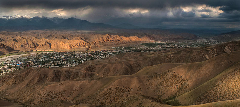
- Overlook of Naryn from the south
- Settlement.image_flag
- Нарын шаарынын туусу.svg
- Settlement.image_seal
- Naryn coa.svg
- Settlement.pushpin_map
- Kyrgyzstan
- Settlement.pushpin_label_position
- bottom
- Settlement.pushpin_mapsize
- 300
- Settlement.pushpin_map_caption
- Location in Kyrgyzstan
- Settlement.subdivision_type
- Country
- Settlement.subdivision_type1
- Region
- Settlement.subdivision_name
- 25px Kyrgyzstan
- Settlement.established_title
- Founded
- Settlement.established_date
- 1868
- Settlement.leader_title
- Mayor
- Settlement.leader_name
- Kanbolot Tutuev
- Settlement.area_total_km2
- 84
- Settlement.population_as_of
- 2023
via Wikipedia infobox
Wikidata facts
- Instance of
- city
- Country
- Kyrgyzstan
- Population
- 41178
- Area
- 84
- Elevation
- 2044
- Time zone
- UTC+06:00
- Capital of
- Naryn District
- Image
- Naryn overlook.jpg
- Dialing code
- 722600
Show 5 more facts
- Commons category
- Naryn (town)
- postal code
- 722600
- category of associated people
- Category:People from Naryn
- topic's main category
- Category:Naryn (town)
- P12749
- Wilstorf
via Wikidata · CC0
Travel guide
Understand
thumb|Naryn River Naryn has a population of 52,300 people.
Get around
Shared taxis are a convenient way to get around. On the main road, taxis are treated like marshrutkas, meaning people get on and off. As of August 2015, the fare for a ride is a mere 10 som, but can be 20 som if you want to go all the way back to the bridge. Do not pay more!
See
Unique from other cities with its red mountains, you can get a great view of the city if you climbs its hills.
A few statues are visible from the main road, including a Lenin statue.
Do
Koshoi Korgon - ruins of a castle/fortress from the 10–12th centuries. All that remains are the walls. Supposedly a friend of the legendary Manas was buried here. Roughly an hour's drive from Naryn, it's on the same road to Tash Rabat and easily visited. A small museum is located nearby. Make sure your driver stops here on the way to or from Tash Rabat. National Park Salkyn-Tor occupies 4,228 ha. Locals love this place for picnic areas. Nice hiking to the alpine lake, a pretty moderate hike with a gentle incline and incredible views throughout. Bargain with a taxi, road is fine to the entrance of the park (20 som per person)
Buy
thumb|Naryn Market|upright=1.2
Eat
Restaurants are north of the street where the guesthouses are located. Just walk up the street and follow the music.
Sleep
The CBT (Community Based Tourism) office is located 200 m from the marshrutka/taxi station. A board in English tells you where it is. The office is essential to helping set you up with a guesthouse, as there are no signs for guesthouses. Arrive in Naryn before the CBT office closes at 17:00 or 18:00 so you can have a place to stay for the night. CBT's official price list quotes 600 som per person per night for any B&B.
Go next
Tash Rabat – Naryn is the gateway to visiting this 500 year old pitstop on the Silk Road, one of the highlights of Kyrgyzstan.
Jalal-Abad – Instead of heading back to Bishkek and from there to Osh, you might choose to go directly to Jalal-Abad, a convenient transport hub. This can be much faster but certainly not cheaper.
Bishkek, Kazarman, At-Bashy
Travel guide from Wikivoyage (CC BY-SA 4.0)
~3 min read
Encyclopedic overview
7 sectionsContents
- History
- Overview
- Demographics
- Economics
- Climate
- References
- External links
Naryn ( ; ) is the regional administrative center of Naryn Region in central Kyrgyzstan. Its area is , and its estimated population was 41,178 as of January 2021. The town was established as a fortress on the caravan route in 1868. It is situated on both banks of the river Naryn (one of the main headwaters of the Syr Darya), which cuts a picturesque gorge through the town. The city has two regional museums and some hotels, but is otherwise residential.
==History== thumb|left|Map including Naryn (Defense Mapping Agency|DMA, 1983) Naryn was established as a fortress on the important caravan route between Kashgar and Zhetysu (Semirechye) at the direction of the first Governor-General of Russian Turkestan Konstantin Petrovich von Kaufmann in 1868.
Excerpted from Wikipedia’s “Naryn” article, available under the CC BY-SA 4.0 licence.
Gallery (11)
On the map
3 mapped locations