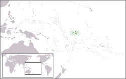
File:LocationPhoenix.png · Wikimedia Commons · See Wikimedia Commons
The Phoenix Islands is an archipelago, or chain of islands, located in the Pacific Ocean. It matters because it represents an important part of the world's ocean geography and ecosystems.
AI-generated from the Wikipedia summary — may contain errors.
Key facts
- Location
- Pacific Ocean
- Area
- 32.3 km (12.5 sq mi)
- Administrative division
- None
- Largest island settlement
- Canton Island (pop. 20)
- Status
- Unincorporated ( Howland and Baker Islands )
via Wikipedia infobox
Wikidata facts
- Country
- Kiribati
- Located in
- Kiribati
- Capital
- Kanton Island
- Population
- 41
- Area
- 27.92
- Time zone
- UTC+13:00
- Body of water
- Pacific Ocean
Show 4 more facts
- Commons category
- Phoenix Islands
- topic's main category
- Category:Phoenix Islands
- native label
- Phoenix Islands
- described by source
- Encyclopædia Britannica 11th edition
via Wikidata · CC0
~23 min read
Encyclopedic overview
(Learn how and when to remove this message)
The Phoenix Islands, or Rawaki, are a group of eight atolls and two submerged coral reefs that lie east of the Gilbert Islands and west of the Line Islands in the central Pacific Ocean, north of Samoa. They are part of the Republic of Kiribati. Their combined land area is 28 square kilometres (11 mi). The only island of any commercial importance is Canton Island (also called Abariringa). The other islands are Enderbury, Rawaki (formerly Phoenix), Manra (formerly Sydney), Birnie, McKean, Nikumaroro (formerly Gardner), and Orona (formerly Hull).
Excerpted from Wikipedia’s “Phoenix Islands” article, available under the CC BY-SA 4.0 licence.
Gallery (4)
On the map
13 mapped locations