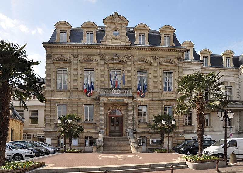
File:Saint-Cloud_Town_Hall_002.JPG · Wikimedia Commons · See Wikimedia Commons
Also known as Pont-la-Montagne, La Montagne-Chérie, St. Cloud
法国上塞纳省市镇
OverviewAI-generated
Saint-Cloud is a commune in France, situated within the Hauts-de-Seine department and the Grand Paris region. It serves as the capital of the canton of Saint-Cloud and is located in the arrondissements of Boulogne-Billancourt and Nanterre. The town shares borders with Suresnes, Paris, Boulogne-Billancourt, and Sèvres, and is positioned next to the Seine river. Its official name includes Saint-Cloud, La Montagne-Chérie, and Pont-la-Montagne.
The area covers 7.56 square kilometers with an elevation of 164 meters above sea level. The population is 30,193, comprising 14,319 males and 15,654 females. Saint-Cloud is twinned with Bad Godesberg, Kortrijk, Frascati, and Windsor and Maidenhead. A supermarket is located within the city, which is in the Île-de-France state.
Synthesized by Vinony from 52 facts across 7 sources: Wikidata, Openweathermap, Open Meteo, OpenStreetMap, GeoNames, Vinony graph, Geo. Generated from structured data (not the Wikipedia text) and checked against those facts — may still contain errors.
Weather now
7-day forecast
via Open-Meteo
Place details
- Locality
- Saint-Cloud
- Region
- Île-de-France
- Country
- France
- Population
- 28,839
- Timezone
- Europe/Paris
via OpenStreetMap · GeoNames
Key facts
- French commune.name
- Saint-Cloud
- French commune.commune status
- Commune
- French commune.image
- Saint-Cloud Town Hall 002.JPG
- French commune.caption
- The Hôtel de Ville
- French commune.image coat of arms
- Blason ville fr Saint-Cloud (Hauts-de-Seine).svg
- French commune.map
- Saint-Cloud map.svg
- French commune.map caption
- Location (in red) within Paris inner suburbs
- French commune.arrondissement
- Nanterre
- French commune.canton
- Saint-Cloud
- French commune.INSEE
- 92064
- French commune.postal code
- 92210
- French commune.mayor
- Éric Berdoati
- French commune.party
- DVD
- French commune.term
- 2020–2026
- French commune.intercommunality
- Grand Paris
- French commune.elevation m
- 136
- French commune.area km2
- 7.56
via Wikipedia infobox
Wikidata facts
- Instance of
- commune of France
- Official name
- Pont-la-Montagne
- Country
- France
- Located in
- Grand Paris
- Population
- 29855
- Area
- 7.56
- Elevation
- 99
- Time zone
- UTC+02:00
- Body of water
- Seine
- Shares border with
- Rueil-Malmaison
- Official website
- www.saintcloud.fr
- Image
- Saint-Cloud @ Quai du Quatre-Septembre.jpg
Show 21 more facts
- twinned administrative body
- Settat
- topic's main category
- Category:Saint-Cloud
- Commons category
- Saint-Cloud
- category for people born here
- Category:Births in Saint-Cloud
- category for people who died here
- Category:Deaths in Saint-Cloud
- postal code
- 92210
- category of associated people
- Category:People from Saint-Cloud
- associated electoral district
- canton of Saint-Cloud
- male population
- 14319
- female population
- 15654
- social media followers
- 2529
- P8168
- Atlascopcosaurus
- described by source
- Encyclopædia Britannica 11th edition
- email address
- mailto:[email protected]
- phone number
- +33-1-47-71-53-00
- official jobs URL
- www.saintcloud.fr/offre-emploi
- sitemap URL
- www.saintcloud.fr/sitemap
- contact page URL
- www.saintcloud.fr/form/contact
- impressum URL
- www.saintcloud.fr/mentions-legales
- privacy policy URL
- www.saintcloud.fr/protection-de-vos-donnees
Sources (11)
via Wikidata · CC0
Article · 中文
圣克卢(法語:Saint-Cloud,法语发音:[sɛ̃ˈklu] ()),法国中北部城市,法兰西岛大区上塞纳省的一个市镇,隶属于楠泰尔区,其市镇面积为7.56平方公里,2019年1月1日时人口数量为30,012人,在法国城市中排名第276位。 圣克卢位于上塞纳省中部,塞纳河左岸,距离巴黎市政厅大约12公里。圣克卢曾为奥尔良家族的一处封地,因其境内的而闻名,近代逐渐发展成为巴黎西部的一个近郊卫星城,通过大区列车L线及多条公交线路连接巴黎市区。
Abstract from DBpedia / Wikipedia · CC BY-SA
Gallery (15)
On the map
3 mapped locations
Available in 68 languages
- Español
- Français
- Deutsch
- 中文
- 日本語
- Русский
- Português
- Italiano
- العربية
- Aragonese
- Armenian
- Asturian
- azb
- Azerbaijani
- Bahasa Indonesia
- Bambara
- Basque
- Belarusian
Show 49 more
- Catalan
- Cebuano
- Chechen
- Chuvash
- Croatian
- Czech
- Danish
- Egyptian Arabic
- Esperanto
- Finnish
- Greek
- Hungarian
- Kabyle
- Kazakh
- Latin
- Latvian
- Lithuanian
- lld
- Luxembourgish
- Malagasy
- Malay
- Mazanderani
- Nederlands
- Norwegian
- nrm
- Occitan
- Piedmontese
- Polski
- Romanian
- Serbian
- Serbian (Latin)
- Silesian
- simple
- Slovak
- Slovenian
- Svenska
- Swahili
- Tatar
- Tiếng Việt
- Türkçe
- Ukrainian
- Urdu
- Venetian
- Volapük
- Waray
- Wu Chinese
- zh_min_nan
- فارسی
- 한국어
via Wikidata sitelinks · CC0