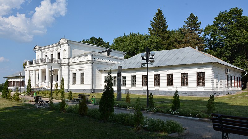
File:Trostyanets'_Sadybniy_Komleks_Sadyba_Keniga_Golovniy_Budynok_01_Myru_14...16...20_(YDS_7766).JPG · Wikimedia Commons · See Wikimedia Commons
Trostianets
Sign in to saveAlso known as Trostyanets
Trostyanets (, ; ) is a city in Okhtyrka Raion of Sumy Oblast of northeastern Ukraine. It was the administrative center of Trostianets Raion until it was abolished on 18 July 2020. The city lies on the Boromlya River, from Sumy. Landmarks include a neo-Gothic "round courtyard" (1749), the late Baroque church of the Annunciation (1744–50), the 18th-century Galitzine palace, and a "grotto of nymphs" (an 1809 centenary memorial to the Battle of Poltava). The city has a population of
In the Vinony graph
Vinony's link graph records 59 inbound references to Trostianets, and connects out to Ukraine, Russian and World War II.
The entry is geolocated on the map in city_source, across 2 mapped points.
It is catalogued under topics including Akhtyrsky Uyezd, Cities in Sumy Oblast and Cities of district significance in Ukraine.
Vinony links it to 44 Wikipedia language editions.
Key facts
- Settlement.settlement_type
- City
- Settlement.image_skyline
- Trostyanets'_Sadybniy_Komleks_Sadyba_Keniga_Golovniy_Budynok_01_Myru_14...16...20_(YDS_7766).JPG
- Settlement.imagesize
- 270px
- Settlement.image_caption
- Manor of the Nadarzhinsky-Golitsyns
- Settlement.subdivision_type
- Country
- Settlement.official_name
- Trostyanets’
- Settlement.image_shield
- Trostyanets_gerb.png
- Settlement.image_flag
- Trostyanec1_h.gif
- Settlement.subdivision_type1
- Oblast
- Settlement.subdivision_type2
- Raion
- Settlement.subdivision_name1
- Sumy Oblast
- Settlement.subdivision_name2
- Okhtyrka Raion
- Settlement.parts_type
- Control
- Settlement.parts_style
- para
- Settlement.population_total
- 19544
- Settlement.population_as_of
- 2022
- Settlement.area_total_km2
- 23.8
- Settlement.established_date
- 1660
via Wikipedia infobox
Wikidata facts
- Instance of
- urban-type settlement
- Official name
- Тростянець
- Country
- Ukraine
- Located in
- Trostianets Raion, Sumy Oblast
- Population
- 19985
- Area
- 23.8
- Elevation
- 118
- Time zone
- UTC+02:00
- Official website
- trostyanets-miskrada.gov.ua
- Image
- Trostyanets' Sadybniy Komleks Sadyba Keniga Golovniy Budynok 01 Myru 14...16...20 (YDS 7766).JPG
- Dialing code
- 5458
- Licence plate code
- BM
Show 7 more facts
- topic's main category
- Category:Trostianets, Sumy Oblast
- Commons category
- Trostianets, Sumy Oblast
- native label
- Тростянець
- inception
- 1660-00-00
- on focus list of Wikimedia project
- WikiProject Ukraine
- time of earliest written record
- 1660-00-00
- postal code
- 42603
via Wikidata · CC0
~8 min read
Encyclopedic overview
13 sectionsContents
- History
- 2022 Russian invasion of Ukraine
- Population
- Ethnicity
- Language
- Nature and recreation
- Industry
- Transport
- Sports
- Notable people
- Gallery
- References
- External links
Trostyanets (, ; ) is a city in Okhtyrka Raion of Sumy Oblast of northeastern Ukraine. It was the administrative center of Trostianets Raion until it was abolished on 18 July 2020. The city lies on the Boromlya River, from Sumy. Landmarks include a neo-Gothic "round courtyard" (1749), the late Baroque church of the Annunciation (1744–50), the 18th-century Galitzine palace, and a "grotto of nymphs" (an 1809 centenary memorial to the Battle of Poltava). The city has a population of
Many were killed and the city was badly damaged during the 2022 Russian invasion of Ukraine.
Excerpted from Wikipedia’s “Trostianets” article, available under the CC BY-SA 4.0 licence.
Gallery (17)
On the map
2 mapped locations